Download
1 / 13
130 likes | 156 Vues
This article discusses the current and future use of HDF format in MODIS and VIIRS Land data. It explains the different spatial resolutions, spectral bands, and on-board calibrators used in MODIS. It also outlines the planned transition to HDF5 format and the challenges and improvements in HDF implementation. The article concludes with the planned usage of HDF in VIIRS Land and Ocean data.

E N D
MODIS (and VIIRS Land) Current and Future use of HDF Robert WolfeNASA Goddard Space Flight Center Code 614.5, Greenbelt, MDrobert.e.wolfe@nasa.gov
Terra and Aqua MODIS • 3 Nadir Spatial Resolutions • 250m (1,2), 500m (3-7), and 1km (8-36) • 4 Focal Plane Assemblies (FPAs) • VIS, NIR, SMIR, and LWIR • 36 Spectral Bands • Reflective solar bands (1-19, and 26), thermal emissive bands (20-25, 27-36) • On-Board Calibrators (OBCs): • Solar diffuser (SD) • SD stability monitor (SDSM) • Blackbody (BB) • Spectro-radiometric calibration assembly (SRCA) • Space view (SV) • Science Applications • Land, oceans, and atmosphere • Nearly 40 science products generated and distributed Terra (EOS-AM) Launched Dec.1999 First light Feb. 2000 Aqua (EOS-PM) Launched May 2002 First light June 2002 Page 2
Current MODIS HDF Usage • MODIS Level 1 (L1), Atmosphere and Land product formats are • HDF4 • HDF4-EOS structural metadata (swath and grid) • ECS core metadata (ODL string) • Mostly SDSs and Attributes (some VDATA) • Internal compression • Geolocation stored in swath products both internally (reduced resolution) and externally (full resolution) • MODIS Oceans (SeaWiFS heritage) product formats are • HDF4 • “ECS core equivalent” metadata stored as attributes (matches SeaWifs format) • Mostly SDSs and Attributes (some VDATA for L3 intermediate products) • External compression (i.e. gzip) 3
MODIS HDF4 Commentary Commentary – my views, not official MODIS views • “Simple” HDF Attributes should have been used for both HDF-EOS structural metadata and ECS core metadata If attributes had been used then: • It would have been easier for users to read metadata fields using the standard HDF library (without SDP library) • It would have made it easier for Science Team developers to read/write metadata • Some lessons learned for Terra (and Aqua) were applied to the Aura mission data formats 4
Planned MODIS HDF Usage • MODIS will (likely) provide products in HDF5 in 2011 timeframe L1, Land, Atmosphere: • Initially, HDF5 will be offered as one format available as a Post-processing option (i.e. like GeoTIFF) for MODIS Collection 6 products • MODIS Collection 6 reprocessing will start early 2010 and be completed by end of 2010 • HDF5-EOS structural metadata • ECS core metadata fields are likely to be stored as simple HDF5 attributes • Internal compression will be used • Later, PGEs (science software) I/O may be rewritten to read/write HDF5 • Oceans • Switch to HDF5 will be driven by user community • HDF5 will be used for Aquarius (produced by SeaWiFS group) • SeaDAS user tool will be modified to read/write HDF5 as well as HDF4 5
VIIRS Visible, NIR and SWIR Bands bbb ccc CO2 O2 O3 H2O O2 H2O H2O H2O O2 H2O CO2 H2O
Current VIIRS Land PEATE HDF Usage • VIIRS Land PEATE converts NOAA IDPS provided products from HDF5 to HDF4 to be compatible with MODIS • Aggregates data to L1/L2 data to ~5 min. granules • Simple HDF attributes used for metadata • All VIIRS Science Data Record (SDR, L1) and EDR Environmental Data Record (EDR, L2/3) software have been converted to run with HDF4 data • I/O wrapper is used in algorithms • DDR (Diagnostic Data Record, L2/3) software reads/writes HDF4 • NASA Direct Broadcast (DB) Laboratory is modifying I/O wrapper to read/write standard IDPS HDF5 products to support DB community 8
VIIRS HDF5 Commentary Commentary – my views, not official Land PEATE views • HDF5 implementation by IDPS has several major flaws • Complex data structures were developed to support aggregation by time and by products • Simple HDF5 features (dimensions, units, etc.) are not being used; instead these fields are stored as HDF attributes • Un-aggregated granules are much shorter than 5 minutes (~1 minute) so they are many (many) files to deal with • For SDRs, each band is stored separately, unless specifically ordered as band aggregates by users 9
Planned VIIRS Land PEATE HDF Usage Note: The VIIRS Land PEATE is funded to help the NASA science team to evaluate the VIIRS SDR and Land EDR products, not to distribute them (or the DDRs) to the general science community • There will likely be a “convergence” MODIS/VIIRS SDR and Land EDR HDF5 product formats • A “rational” HDF5-EOS format will be used (see earlier MODIS Land HDF5 discussion) • MODIS HDF4/5 converter will be modified to also work with VIIRS • Likely to be available in the early VIIRS post-launch timeframe (mid-2011) • This will only be available to the general science community if NASA policy changes 10
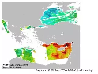
Planned VIIRS Ocean PEATE HDF Usage Note: The VIIRS Ocean PEATE is funded to help the NASA science team to evaluate the VIIRS SDR and Land EDR products, not to distribute them (or the DDRs) to the general science community • If the NASA policy changes, there will likely be a “convergence” MODIS/VIIRS Ocean EDR HDF5 product formats produced by the VIIRS Ocean PEATE (see earlier MODIS Ocean HDF5 discussion) 11
MODIS/Aqua Haze over China and KoreaOct. 28, 2009