Download
1 / 19
190 likes | 217 Vues
A review of 2005-06 Extreme Events. Klaus Weickmann, ESRL/PSD. Background and variables used Extreme sea surface temperatures Focus on 850 mb temperature anomalies also Dartmouth Flood Monitor 1968-2006 and Oct 2005-Sept 2006 > 2 sigma anoms; < -2 sigma anoms

E N D
A review of 2005-06 Extreme Events Klaus Weickmann, ESRL/PSD • Background and variables used • Extreme sea surface temperatures • Focus on 850 mb temperature anomalies • also Dartmouth Flood Monitor • 1968-2006 and Oct 2005-Sept 2006 • > 2 sigma anoms; < -2 sigma anoms • Northern Hemisphere time series of % area • Global map of % days with extreme temps • Extreme cases (1998, 2002, 2003, 2005, 2006) • Speculation on Synoptics • USA monthly temp and precip xtremes Special thanks to: Cathy Smith, Don Hooper, Klaus Wolter, Alex McColl, Barry McInnes
May-Sep 1998, 2002, 2003, 2005, 2006 composites on right SSTA H H L L L H H 200uv OLRA
Temperature 850 hPa Annual mean standard deviation 1968-2006 Annual mean 1968-2006 Note: full seasonal cycle of standard deviation used in analysis that follows
‘98 850 temperature Oct ’68 – Sep ’06 91-day running mean ‘06 ‘03 ‘05 < -2 σ ‘02 > +2 σ % area 20-90N ~Jan ‘77 Pinatubo ‘82-83 Mean 2.46% 2.06%
Oct 1968 to Sep 2006 % days > +2 σ Shading: 2-4%, 4-6%, >6% % days < -2 σ orography not “blocked out”
11 Sep 850 temperature Oct ’05 – Sep ’06 daily plus 91-day running mean 15-16 Aug < -2 σ > +2 σ 21 Jul 8.7% % area 20-90N 11 Jul 2%
3.5C! Oct 1968 to Sep 2006 850 mb temperature anomalies (degrees C) Shading: 0.5-1.0, 1.0-2.0, 2.0-3.0 850 mb temperature normalized anomalies Shading: 0.5-1.0, 1.0-1.5
Oct 2005 to Sep 2006 % days > +2 σ Shading: 5-10%, 10-15%, >15% % days < -2 σ orography not “blocked out”
‘98 850 temperature Oct ’68 – Sep ’06 91-day running mean ‘06 ‘03 ‘05 < -2 σ ‘02 > +2 σ % area 20-90N ~Jan ‘77 Pinatubo ‘82-83 Mean 2.46% 2.06%
Percent of days out of 91 with 850 hPa normalized temperature anomalies greater than +2 sigma Shading levels 8-16%, 16-32%, 32-48%, >48% Jun 13 – Sep 11, 1998 May 20 – Aug 18, 2002 Jul 14 – Oct 3, 2005 Aug 3 – Nov 3, 2003 Jul 12 – Oct 10, 2006
Daily dates with maxima in % area > +2 sigma during Jul 12 – Oct 10 2006 USA west coast heat wave
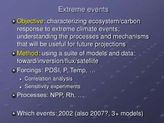
Speculation on Synoptics Two areas of tropical forcing due to extreme SSTs in warm pool region MJO-like behavior: faster time scale and consolidation of anomalies, esp. summer/fall? Leads to more transient “split flows” with stronger westerly winds in tropics & subtropics Favors extreme ridging events and subtropical jets spiraling into mid-latitudes Reflecting increased heat transport due warm tropical SSTs?
Summary and Conclusions • Expanded > 29C SSTs in warm pool region, especially since July 2001 • 2005-06 continues recent string of extreme temperatures during summer/fall, and more general trend of increasing warm extremes • > 2 sigma more often, over larger area and especially at warm time of year • Synoptic discussion of Nov-Dec 2005 (USA west coast precip), April 2006 (CA precip) and June 2006 (USA east coast precip) extreme events @ http://www.cdc.noaa.gov/MJO/Forecasts/climate_discussions.html
Possible impact of assimilation model errors on results?