Download
1 / 24
240 likes | 373 Vues
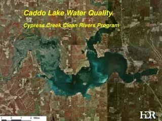
Water Quality Reductions in Hawk Creek Watershed and Land Retirement In Renville County. Joe M. Stangel - Renville SWCD Patrick Baskfield - MPCA. Hawk and Beaver Creek Watersheds.

E N D
Water Quality Reductions in Hawk Creek Watershed and Land Retirement In Renville County Joe M. Stangel - Renville SWCD Patrick Baskfield - MPCA
Between 1999 and 2006, substantial reductions in flow weighted mean concentrations of several water quality parameters have been documented for both Hawk and Beaver Creeks located the Upper Minnesota river Basin West Fork Beaver Creek Hawk Creek near Maynard
Reductions have occurred with both sediment and phosphorus; what happened? Blue Earth River Le Sueur River West Fork Beaver Creek 6/2/2004 Watonwan River
Total Suspended Solids (TSS) Flow Weighted Mean Concentrations TSS surrogate value for noncompliance with State turbidity standard (58 mg/L for WCBP ecoregion)
Nitrate nitrogen flow weighted mean concentrations show an increasing trend
Summary • Monitoring data from 1999-2005 show 45-50% reductions in sediment flow weighted mean total suspended flow weighted mean concentrations and 20-25% reductions in phosphorus flow weighted mean concentrations (conservative estimates) • Nitrate nitrogen flow weighted mean concentrations have increased 20 to 30% during this same time period.
Renville County Agricultural Statistics 2005 • #1Corn for Grain • #1Green Peas • #1Sweet Corn • #3Soybeans • #5Sugar Beets • #5Dry Edible Beans • #5Pig Crop 575,177 Cropland Acres
Renville County Conservation Program Statistics 2006 • CREP 9,501.4 • RIM 4,922.7 • CCRP 3,579.1 • CRP 2,044.7 • WRP 1,513.0 • RIM/WRP 311.3 Total Private Lands Conservation, 21,872.2 acres Or 3.8% percent of total county area.
Mass Mailings Land Specific Quotes One on One Contacts Landowner Example Indirect Marketing Easement History Square Things Up Tax Break Payments Investment for future Lender Referrals Hunting Land Legacy Marginal Land Target Direct Marketing
Outside Influence • Freedom to Farm Act • Economic Climate • Competitive Payments • Easement History
Beaver Creek Reaches • Buffer 40% • ½ Buffer 10% • No Buffer 50% • 176 Easements (RIM, CREP) • 6,561 acres
GIS Skills • Thanks to: Shawn Weick - NRCS Jason Ewert - MPCA