The Arc-Node Data Model
Spatial Data The Arc-Node Data Model. The Arc-Node Data Model.

The Arc-Node Data Model
E N D
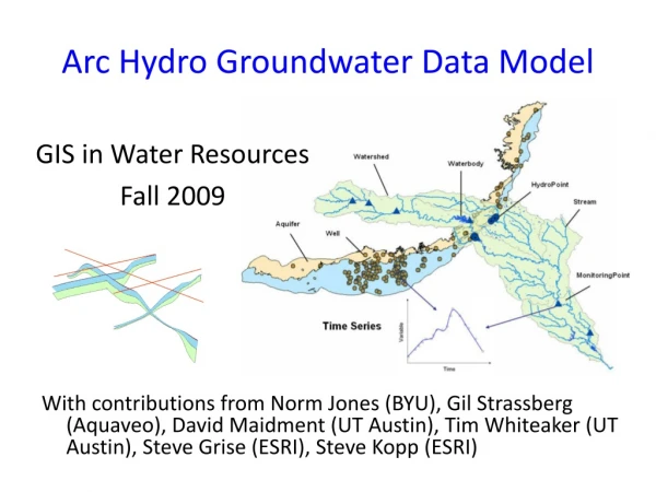
Presentation Transcript
Spatial DataThe Arc-Node Data Model The Arc-Node Data Model A data model is the fundamental structure of a database designed to organize diverse components of data for effective retrieval and processing. The data model lays the foundation of a GIS in the sense that the design of the data model determines how the data are organized and processed.
The Arc-Node data model is an effective vector based data model first adopted by the US Census Bureau for building the geographic base file (GBF) of the 1980 census. Based on this model, streets and other line features in the United States are organized in a file system known as dual independence map encoding (DIME). In the Arc-Node Data Model, arcs form the most basic units on a map.
Spatial DataThe Arc-Node Data Model A simple polygon coverage of the arc-node data model
Spatial DataThe Arc-Node Data Model In this model, every arc consists of two nodes: a start node and an end node. Between the nodes, an arc could have zero or any number of vertices. The shape and length of an arc are determined by the location of the nodes and vertices. A node is different from a vertex in that nodes are topological features.
Spatial DataThe Arc-Node Data Model In this model, a map display is comprised of four regions represented by polygons 101, 102, 103 and 104
The polygons are delineated by seven arcs (33, 34, 35, 36, 37, 38, 39). Every arc has two nodes (start and end).
Arc 33, which represents the simplest form of line features, has no vertex between the nodes, depicting a straight line segment.
Other arcs have one or more vertices between nodes to delineate a more complicated shape. As shown, Arc 36 has four vertices. An important requirement of the arc-node data model is that either end of an arc is always defined by a node.
Other arcs have one or more vertices between nodes to delineate a more complicated shape. As shown, Arc 36 has four vertices. An important requirement of the arc-node data model is that either end of an arc is always defined by a node. Vertice 1 Vertice 2 Vertice 3 Vertice 4
Spatial DataThe Arc-Node Data Model Nodes are topologically meaningful in that they represent the junctions between line features. In the arc-node data model, a point feature can be treated as a “degenerate” line feature with the start node over-lapping the end node and no vertices in between. Each point feature can be represented by one node because start and end nodes are identical. Each polygon feature, as seen in the illustration is treated as a series of connecting arcs that delineate the boundaries of the polygon. To construct the topological relationships among polygon features, every intersection must be defined as a node. The reason for this is that crossing two arcs without defining a node at the intersection would make identifying the relationship between two adjacent polygons impossible.
Spatial DataThe Arc-Node Data Model The most important advantage of the arc-node data model is its effectiveness in coding topological relationships. For example, assume that you want to know whether two polygons are adjacent to one another. A simple way to find the answer is by looking at the list of arcs that define these two polygons. If at least one arc exists, which is part of both polygons then the two polygons are adjacent to one another. In GIS operations, ESRI’s ARC/INFO is based on the arc-node data model and organizes spatial feature data in separate relational data files. Appearing on the next page are the two most important attribute tables for spatial analysis incorporated in ARC/INFO, the polygon attribute table (PAT) and the arc attribute table (AAT), for the polygon coverage shown on the next page.
Spatial DataThe Arc-Node Data Model The Polygon Attribute Table (PAT)
Spatial DataThe Arc-Node Data Model The Polygon Attribute Table (PAT) The PAT lists all polygon features in the coverage. The first record in the PAT, called the “universe polygon” represents the aggregated area extent of all polygons in the coverage. The four valid polygons are referenced internally by a #-ID and a user specified polygon ID (I.e. 101 to 104). The area and perimeter of the polygons are computed when the coverage is generated.
Spatial DataThe Arc-Node Data Model The Polygon Attribute Table (PAT) The “Universe Polygon” = 4.506
Spatial DataThe Arc-Node Data Model The Arc Attribute Table (AAT)
Spatial DataThe Arc-Node Data Model The Arc Attribute Table (AAT) The AAT lists every arc as a single record referenced by both an internal #-ID and a user-specified arc ID (i.e. 33 to 39). The start node (F-node) and end node (T-node) and the polygons on both sides of each arc (L-poly and R-poly) provide the necessary topological information about the polygons and arcs.
Spatial DataThe Arc-Node Data Model The Arc Attribute Table (AAT) Note that the L-poly and R-poly refer to the internal #-ID of polygons in the Point Attribute Table (PAT). For example L-poly 3 in the AAT is equivalent to the polygon with the Poly-ID of 102 in the PAT. The length of every arc is also computed when the coverage is generated.
AAT PAT
AAT Displaying the connectivity between the AAT and PAT tables PAT
Adjacency To determine whether two polygons are adjacent, the analyst can simply examine the arcs that delineate both polygons to determine if an arc exists that is shared as a common border between polygons.
To determine whether polygons 102 and 103 are adjacent, the analyst can examine the L-Poly and R-Poly in the AAT to identify any arc which has the two polygons on both sides.
Spatial DataThe Arc-Node Data Model PAT Are polygons 102 and 103 adjacent?
Spatial DataThe Arc-Node Data Model PAT Are polygons 102 and 103 adjacent?
Spatial DataThe Arc-Node Data Model PAT In the PAT, 102 & 103 are #-ID: 3 & 5
Spatial DataThe Arc-Node Data Model Scan L-Poly and R-Poly to see if ID’s 3 & 5 are adjacent AAT
Spatial DataThe Arc-Node Data Model Result::3 is the L-Poly and 5 is the R-Poly, and the Arc-ID = 33 AAT
Spatial DataThe Arc-Node Data Model Containment To determine whether Polygon A is contained in Polygon B, the analyst must first select all arcs that delineate Polygon A, and then examine the Polygon ID’s on both sides of the selected arcs. If all selected arcs have Polygon A on one side and Polygon B on the other side of every arc, then Polygon A must be contained by Polygon B.
Spatial DataThe Arc-Node Data Model PAT Scan PAT for Polygon 101
Spatial DataThe Arc-Node Data Model PAT Result: #-ID = 4
Spatial DataThe Arc-Node Data Model AAT By scanning the AAT table, indicates Polygon 101 is delineated by Arc 37 PAT
Spatial DataThe Arc-Node Data Model AAT Since the area of polygon 101 is the least of the other polygons, it is safe to assume that the area of polygon 101 can be contained within a larger polygon PAT
Spatial DataThe Arc-Node Data Model AAT PAT Scan the L-Poly and R-Poly= Poly #-ID=2 or Poly ID 104
Spatial DataThe Arc-Node Data Model AAT PAT The large polygon The contained polygon
Spatial DataThe Arc-Node Data Model Connectivity The connectivity of arcs can be determined from the attributes of the F and T-Nodes in the AAT, that is, two arcs are directly connected if both are linked to the same node. Example arcs 38. 33, and 39 share a common node, therefore, these three arcs are directly connected. Coversely, arc 37 is not connected to any other arc, because no other arc is linked to the only node defining it.
Spatial DataThe Arc-Node Data Model AAT To determine connectivity relationships among arcs, scan the F and T nodes in the AAT table.
Spatial DataThe Arc-Node Data Model AAT To determine connectivity relationships among arcs, scan the F and T nodes in the AAT table.
Spatial DataThe Arc-Node Data Model AAT Result shows arcs 38, 33 and 39 share a common node
Spatial DataThe Arc-Node Data Model AAT Conversely, arc 37 is not connected to any other arc, because no other arc, as can be seen, is linked to the only node defining it.
Conclusions The Arc-Node Data Model The examples of adjacency, containment and connectivity illustrates an important property of the arc-node data model: topological relationships are traceable because the required topological information is incorporated in the data files. In addition, location data organized by x and y coordinates for every node and vertex in internal files can be retrieved as necessary. Attribute data can be either attached to the AAT or the PAT, or organized in other tables for referencing through a relational database.
The Arc-Node Data Model Because all three required components of spatial data are integrated in this data model, the ARC/INFO GIS provides an effective tool for processing spatial information. The arc-node data model, or a modified form, has been adopted by manufacturers of well-developed vector based GIS software. The capability of embedding topological relationships in the arc-node data model provides the foundation for vector-based GIS to effectively handle complex spatial analysis tasks.