Download
1 / 32
320 likes | 334 Vues
This project aims to establish long-term hydrometeorological observatories in target regions to study climate variability, water-related parameters, and the impact of human activities on hydroclimate variations. It includes the development of super-sites and pilot-sites dedicated to process studies and integrative studies at regional scales, as well as post-event surveys after major events in the Mediterranean. The project also emphasizes the cooperation of NWP centers, data assimilation, and the exchange of scientific information and data.

E N D
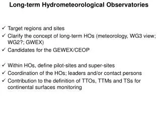
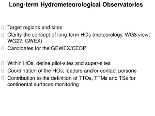
Long-term Hydrometeorological Observatories • Target regions and sites • Clarify the concept of long-term HOs (meteorology, WG3 view; WG2?; GWEX) • Candidates for the GEWEX/CEOP • Within HOs, define pilot-sites and super-sites • Coordination of the HOs; leaders and/or contact persons • Contribution to the definition of TTOs, TTMs and TSs for continental surfaces monitoring
Ticino Friuli Veneto Croatia Cévennes + LR CA + Liguria Catalonia North Africa? Crete Israël? Target regions / sites
1. Make best use of existing operational observation systems 2. Develop a set of « super-sites » (research watersheds of some 10-km²) dedicated to hydrological process studies 3. Develop a set of « pilot-sites »(research watersheds of some 1000-km²) dedicated to integrative studies at the regional scale 4. Perform post-event surveys after major events occurring in the Mediterranean Long-term Hydrometeorological Observatories (a hydrological WG3 perspective)
GEWEX/CEOP criteria TECHNICAL CRITERIA • Cooperation of an NWP center for provision of atmospheric and land surface data assimilation. • Atmospheric-hydrologic models for studying transferability and climate variability. • Mechanism for collecting and managing adequate hydrometeorological data sets. • Participation in the open international exchange of scientific information and data. • Interactions with hydrologic services and related groups • Commitment of adequate resources and personnel. • Evaluation of GEWEX global data products • Contributions to CEOP in situ, remote sensing, and model output databases. SCIENTIFIC CRITERIA • Observe, simulate, and predict diurnal, seasonal, annual and interannual variability. • Determine climate system variability and critical feedbacks. • Demonstrate improvements in predictions of water-related climate parameters. • Demonstrate the applicability of techniques and models for other regions. • Assess the human impact on hydroclimate variations, including vulnerability to climate change
Sembadel Ardèche Cèze Bollène Gardon Hérault Vidourle Montclar Nîmes Orb Aude Oppoul Agly Têt Long-term Hydrometeorological Observatories:1. Make best use of existing operational observation systems e.g., the Cévennes-Vivarais Mediterranean Hydrometeorological Observatory (OHMCV) Radar and raingauge networks Main watersheds and stream gauges
Long-term Hydrometeorological Observatories:2. Develop a set of « super-sites »Research watersheds of some 10-km² dedicated to process studies • Hillslopes, water pathes, riparian zone • Surface and sub-surface flows and storages • River monitoring (hydrometry, sediment transport) • Evapotranspiration… e.g. in France CVMHO Valescure CVMHO Lez-Coulazou ORE Draix-Bléone Granite and schists Karsts Marls (Alps)
Long-term Hydrometeorological Observatories3. Develop a set of « pilot-sites »Research watersheds of some 1000-km² dedicated to distributed observation and modelling studies at the regional scale • Nested watersheds including super-sites • Soil and landscape description • Rainfall QPE (operational + research radars+ disdrometer and raingauge networks) • Soil moisture monitoring • River monitoring (distributed hydrometry, sediment transport and flood plains) • Vulnerability monitoring Gardon (2000 km²) Valescure (5 km²) Gardon de Saint Jean (200 km²)
Long-term Hydrometeorological Observatories4. Post-event surveys after major events occurring in the Mediterranean Collation of : Rainfall data (raingauges and radar) Maximum discharge estimates from water marks Witness accounts (flood dynamics, sociologic parameters…) Process understanding through hydrologic and hydraulic modelling e.g., 18 September 2007 in Zelezniki, Selska Sora river, Slovenia, HYDRATE project
Task teams for observation (TTO) TTO2 Monitoring continental surfaces … TTO2-x The OHM-CV observatory (deep and shallow convection, multi-scale water budget; distributed flash flood prediction; karsts and floods; social adaptation) TTO2-x The Draix-Bléone observatory (erosion and sediment transport) … TTO2-x The Catalan Observatory (…) TTO2-x The Ligurian Observatory (…) TTO2-x The Friuli Observatory (…) … TTO2-x Post-event surveys after extreme events occurring in the Mediterranean TTO6 Measuring land-sea fluxes ?
Task team for modelling (TTM) … TTMx Multiscale modelling of the continental surfaces …
TASK SUPPORTS TS1 – Data Base TS1-a Geographical information systems; landscape descriptors TS1-b Hydrometeorological data from operational services … TS2 – Coordination of hydrometeorological observatories … TS4 – Satellite products …
TASK SUPPORTS TS1 – Data Base TS1-a Geographical information systems; landscape descriptors TS1-b Hydrometeorological data from operational services … TS2 – Coordination of hydrometeorological observatories … TS4 – Satellite products …
Task teams for observation (TTO) TTO2 Monitoring continental surfaces … TTO2-x Hydrological super-sites TTO2-x Monitoring soil moisture ? TTO2-x Monitoring rivers … … TTO2-x Post-event surveys after extreme events occurring in the Mediterranean TTO3 Measuring surface fluxes over land TTO7 Monitoring vulnerability factors
Task team for modelling (TTM) … TTMx Multiscale modelling of the continental surfaces …
TASK SUPPORTS TS1 – Data Base TS1-a Geographical information systems; landscape descriptors TS1-b Hydrometeorological data from operational services … TS2 – Coordination of hydrometeorological observatories … TS4 – Satellite products …
TASK SUPPORTS TS1 – Data Base TS1-a Geographical information systems; landscape descriptors TS1-b Hydrometeorological data from operational services … TS2 – Coordination of hydrometeorological observatories … TS4 – Satellite products …
Distributed hydrological models • LISFLOOD, Joint Research Center Ispra Italy • AFFDEF, University of Bologna Italy • Coupled MesoNH/SURFEX/Topmodel CNRM Toulouse France • n-Topmodels, EDYTEM Chambéry and LTHE Grenoble, France • ATHYS (HSM Montpellier) and LIQUID (Cemagref Lyon, LTHE Grenoble, Hydrowide): hydrological modelling platforms • 1D-hydraulic models
Posted contributions Cévennes = target region #1 with several projects of OHMCV • Knowledge and Predictability of Heavy Precipitation Events (HPE) in Southeastern France (part of) • Shallow orographic convection contribution to the water resources in Mediterranean: proposition of an observation system within the framework of HyMEx • Impact of rainfall variability and soil moisture redistribution on the continental hydrological cycle and the genesis of flash floods in the Cévennes region (in relation with WG2). • Karst hydrosystems: water resources and flood dynamics (in relation with WG2) • Observations for vulnerability and social adaptation (WG5) • Multi-disciplinary post-event surveys (in cooperation with WG5) Another project in French Southern Alps: • Erosion and sedimentary transport from sources down to piedmont (in relation with WG2 and SICMED)
Main target regions in the NW Mediterranean Friuli Ticino Liguria Cévennes Croatia French S. Alps Languedoc-Roussillon Catalonia • Coastal regions: Catalonia, Languedoc-Roussillon, Côte d’Azur, Liguria • 3 major cities (Barcelona, Marseille Genova) • Medium and high-elevation mountains: Pyrénées, Cévennes, southern Alps, Ticino, Friuli HyMeX WG3 observation strategy based on long-term hydrometeorological observatories
R2 R1 R3 R4 Ardèche Cèze Gardon Hérault Runoff Orb Runoff UR- Aude Runoff UR+ G1 GW+ G2 GW- MEDYCYSS: karsts – water ressources and floods Lez catchment: fresh-water resource for the city of Montpellier Coulazou watershed: a « toy model » for studying the influence of the river-karst interactions on the propagation and intensity of surface floods
Draix-Bléone Draix-Bléone: erosion and sediment transport • Nested watersheds: • Ore Draix : 0.0013 à 1.08 km² • Galabre : 20 km²; Bouinenc : 22 km² • Duyes : 124 km²; Bès : 165 km² • Bléone (Malijai) : 897 km² • Instrumentation: • Raingauge network • Disdrometer • Stream gauges with suspended load samplers • and sediment traps • RFID transponders for bedload tracking • Hydrophone for bedload transport • LIDAR geomorphological surveys with drones • On-site studies • Contribution/expertise for other sites and during post-event surveys
TASK TEAMS FOR OBSERVATION (TTO) TTO1 Sounding the atmosphere TTO1-a Radiosounding (LOP/EOP/SOP) TTO1-b Balloons (SOP) TTO1-c UHF/VHF profilers (LOP/EOP) TTO1-d GPS (LOP/EOP/SOP) TTO1-e Lidars (EOP/SOP) TTO1-f Radars (LOP/EOP/SOP) TTO1-h Microphysics (LOP/EOP/SOP) TTO1-i Aérosols (SOP) TTO1-j Lightning (LOP/EOP/SOP)
TASK TEAMS FOR OBSERVATION (TTO) TTO2 Monitoring continental surfaces …observatories to be sorted by thematics in a second step?... TTO2-x The OHM-CV observatory (deep and shallow convection, multi-scale water budget and distributed flash flood prediction; social adaptation) TTO2-x The Draix-Bléone observatory (erosion and sediment transport) TTO2-x The MEDYCYSS observatory (karsts, water resources and floods) … TTO2-x The Catalan Observatory (…) TTO2-x The Ligurian Observatory (…) TTO2-x The Friuli Observatory (…) … TTO2-x Post-event surveys after extreme events occurring in the Mediterranean TTO3 Measuring surface fluxes over land ? TTO6 Measuring land-sea fluxes ? TTO7 Monitoring vulnerability factors ?
TASK TEAMS FOR MODELLING (TTM) … TTMx Multiscale modelling of the continental surfaces …
TASK SUPPORTS TS1 – Data Base TS1-a Geographical information systems; landscape descriptors TS1-b Hydrometeorological data from operational services … TS2 – Coordination of (in-land) hydrometeorological observatories … TS4 – Satellite products …
Structure d’un « Task Team » d’AMMA (pas de distinction TTO, TTM ; la logistique est incluse) • Scientific justification and objectives • Observation strategy (overall strategy; experimental sites; modelling platforms; satellite products; list of instruments and relevant maps) • Deployment (planning ; logistical considerations) • Partnership (field observation ; training program) • Organisation of the TT (lists of leaders - core group - members; internal coordination; how to handle new requests e.g. about additional instrument; reporting) • Coordination with other TTs
OHM-CV Draix-Bléone MEDYCYSS Marseille Les observatoires en France inter WG (2, 3 et 5) OHM-CV :équipes OHM-CV, MF, SPCGD Convection profonde et peu profonde ; (extension LR, SPCMO à agréger) Processus et bilans hydrologiques ; prévision distribuée des crues, adaptation sociale Draix-Bléone :Cemagref, LTHE, …SPCGD, EDF érosion et transport sédimentaire MEDYCYSS :MEDYCYSS, …BRGM Karst : ressources en eau, crues … autres ? Marseille, NOVIMET+Cemagref Var, EDF/LTHE sur Durance)
OHM-CV: deep and shallow convection studies Radars mobiles bande X Réseaux de disdromètres Réseaux GPS Radiosondages renforcés