Download
1 / 1
10 likes | 198 Vues
A CERES-Consistent Cloud Property And Surface Temperature Climate Data Record Using AVHRR Data Patrick Minnis 1 , Kristopher Bedka 2 , Rabindra Palikonda 2 , Qing Trepte 2 , Patrick Heck 3 , Benjamin Scarino 2

E N D
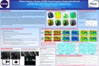
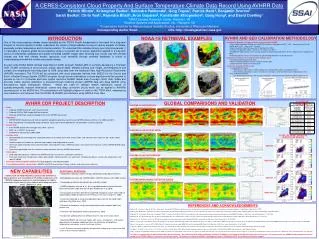
A CERES-Consistent Cloud Property And Surface Temperature Climate Data Record Using AVHRR Data Patrick Minnis1, Kristopher Bedka2, Rabindra Palikonda2, Qing Trepte2, Patrick Heck3, Benjamin Scarino2 Sarah Bedka2, Chris Yost2, Rajendra Bhatt2, Arun Gopalan2, Konstantin Khlopenkov2, Gang Hong2, and David Doelling1 1NASA Langley Research Center, Hampton, VA 2Science Systems and Applications, Inc., Hampton, VA 3Cooperative Institute for Meteorological Satellite Studies, University of Wisconsin-Madison Corresponding Author Email: p.minnis@nasa.gov URL: http://cloudsgate2.larc.nasa.gov INTRODUCTION One of the most pressing climate issues identified by the IPCC's Fourth Assessment is the need for a long-term analysis of cloud properties to better understand the impact of cloud radiative forcing on various aspects of climate, especially surface temperature and its diurnal variation. To understand this radiative forcing over long time periods, it is necessary to measure global cloud properties using a consistent set of proven algorithms applied to a long-term record of consistently calibrated and quality-controlled satellite imager data. Knowing how clouds vary with climate change and how well climate models reproduce such variability through modeled feedbacks is critical to understanding how well the models can predict climate. As part of the NOAA NCDC Climate Data Record (CDR) program, NASA LaRC is currently developing a Thematic CDR (TCDR) consisting of cloud amount, phase, optical depth, effective particle size, height, and temperature and surface skin temperature extending back to 1978 using data from the Advanced Very High Resolution Radiometer (AVHRR) instrument. The TCDR will be consistent with cloud properties derived from MODIS for the Clouds and Earth’s Radiant Energy System (CERES) program, though some modifications to these algorithms will be required to operate on the 4 to 5-channel and lower spatial resolution AVHRR Global Area Coverage (GAC) data. Stable and accurate visible channel calibration is ensured through matching modern AVHRR data with Aqua MODIS using Simultaneous Nadir Overpasses (SNOs). SNOs are used to validate relative calibrations based on spatially/temporally invariant desert/polar scenes and deep convective clouds which can be applied to AVHRRs operating prior to the MODIS era. This presentation will highlight progress to-date on this TCDR effort, emphasizing cloud detection and retrievals from the NOAA-18 AVHRR and validation using NASA A-Train data. NOAA-18 RETRIEVAL EXAMPLES AVHRR AND GEO CALIBRATION METHODOLOGY • 3 Calibration Methods, all independently referenced to Aqua-MODIS • Ray-matched coincident GEO counts and MODIS radiances averaged over a 0.5°x0.5° ocean grid near the sub-satellite point (±15° lat by ±20° lon area) • Deep Convective Cloud Technique (DCC; Doelling et al. 2013) • Invariant-site Approach (Libya-4, Dome-C, etc.; Bhatt et al. 2012) • SCIAMACHY hyperspectral sensor used to account for spectral band differences for the visible channels (Doelling et al. 2013) • IASI hyperspectral sensor use to account for spectral band differences for the IR channels • Calibration of GEO sensors using the three methods above • Use GEO provided space count offset • Perform monthly calibration transfers to derive monthly gains • Compute timeline trends from monthly gains • Calibration of NOAA AVHRR sensors • During MODIS timeframe • Simultaneous nadir overpass (SNO) comparisons with MODIS establish standard gain trend • SNO method validated by invariant-site and DCC techniques, which extend the gain standard back in time • Prior to MODIS timeframe • Use combination of invariant-site and DCC techniques referenced to Aqua-MODIS to determine gain trend Independent NOAA-16 AVHRR Calibrations Independent GOES-12 Calibrations Independent Meteosat-9 Calibrations AVHRR CDR PROJECT DESCRIPTION GLOBAL COMPARISONS AND VALIDATION CLOUD MASK VALIDATION DAYTIME CLOUD FRACTION • Goals • Calibrate AVHRR 0.64, 0.87, and 1.6-µm channels • Calibrate GOES & SMS imager 0.65-µm channels • Generate CERES-like cloud climatology for the entire AVHRR data record • Algorithms • CERES MODIS cloud mask and retrieval algorithm adapted to operate using 5-channel AVHRR radiances (Minnis et al. 2008 and 2011) • Near Simultaneous Ray-Matched, Deep Convective Cloud, and invariant polar/desert site techniques used for calibration • Source Data • 4 km AVHRR Global Area Coverage Data: 1978 – present • SMS-1 & 2; GOES-1 thru present • SCIAMACHY spectral data (2004-2009) • Ancillary Data • NASA MERRA 3-D thermodynamic and ozone profiles at 42 vertical levels with surface fields, and snow/ice cover maps at a 0.5 x 0.66° spatial resolution • Cloud microphysical models for spherical water droplets and roughened ice crystals • 10-minute spatial resolution land surface elevation, land and water maps, IGBP ecosystem, and surface emissivity also used in CERES MODIS cloud retrievals • Dynamically generated clear sky reflectance maps based on clear-sky AVHRR observations • Deliverables • Calibrated 0.63 & 0.86-µm radiances for AVHRR and GEO instruments (calibration coefficients) • Pixel level cloud mask, temperature, height, optical depth, effective particle size, water path, microphysical phase; surface skin temperature, and spectral albedo • Essential Climate Variables Addressed: Cloud properties and radiation budget • Current/Expected User Communities: GEWEX and GCM communities. Energy, aviation, and reinsurance industries DAYTIME CLOUD OPTICAL DEPTH CLOUD TOP HEIGHT VALIDATION IN NON-POLAR REGIONS LaRC Optically Thick (τ > 8) Water Cloud Optically Thin Water Cloud Daytime DAYTIME CLOUD TOP PRESSURE Night-time LaRC NEW CAPABILITIES • ADDITIONAL FEATURES • Independent calibrations tied to the Aqua MODIS 0.63 and 0.86 μm channels • Methodology consistent with CERES Edition 4 MODIS retrievals from 2000- onward • Cloud property retrievals during both day and night (limited) • AVHRR navigation accurate to ±1 km using global database of ground control points defined with visible and near-IR data (Khlopenkov et al. 2010) • Ice cloud phase functions derived via roughened hexagonal crystals which helps to improve optical depth and particle size retrievals in thin cirrus (Yang et al. 2008) • Use of new regionally & seasonally dependent lapse rates for low cloud height estimation (Sun-Mack et al., 2013) • Estimates of cloud base using a parameterization based on optical depth and particle size • Pixel-level skin temperature retrieval (Scarino et al. 2013) • Dynamically updating clear-sky reflectances over snow & non-snow scenes • Specialized BRDF and emissivity models with scene-, atmospheric-, and angular-dependencies to improve modeling of clear sky reflectance and brightness temperatures over ocean, sea ice, and snow surfaces • Use 2-D Fourier transform to identify and eliminate striping across track in pre-KLM series 3.75 μm channel radiances Optically Thick (τ > 8) Ice Cloud Optically Thin Ice Cloud DETECTION OF PENETRATING CONVECTIVE UPDRAFTS Spatial gradients and thresholding of IR window temperatures with MERRA tropopause temperature and thermodynamic stability information used to identify active updrafts within deep convective storms. (Bedka et al. 2010) Daytime DAYTIME WATER DROPLET EFFECTIVE RADIUS LaRC Night-time Overshooting Top Detections atop NOAA-9 Visible REFERENCES AND ACKNOWLEDGEMENTS NOAA-9 Color Enhanced IR Window Bedka, K. M., J. Brunner, R. Dworak, W. Feltz, J. Otkin, and T. Greenwald, 2010: Objective satellite-based overshooting top detection using infrared window channel brightness temperature gradients. J. Appl. Meteor. Climatol., 49, 181-202. Bhatt, R., D. R. Doelling, D. L. Morstad, B. R. Scarino, and A. Gopalan, 2012: Desert-based absolute calibration of successive geostationary visible sensors using a daily exoatmospheric radiance model. Submitted. IEEE Trans. Geosci. Remote Sens., TGRS-2012-01041. Doelling, D. R., B. R. Scarino, D. Morstad, A. Gopalan, R. Bhatt, C. Lukashin, and P. Minnis, 2013: The intercalibration of geostationary visible imagers using operational hyperspectral SCIAMACHY radiances. IEEE Trans. Geosci. Remote Sens., 51, 1245-1254. Doelling, D. R., D. L. Morstad, B. R. Scarino, R. Bhatt, and A. Gopalan, 2013: The characterization of deep convective clouds as an invariant calibration target and as a visible calibration technique. IEEE Trans. Geosci. Remote Sens., 51, 1147-1159. Khlopenkov, K., A. Trishchenko, and Y. Luo, 2010: Achieving subpixelgeoreferencing accuracy in the Canadian AVHRR Processing System. IEEE Trans. Geosci. Remote Sens., 48, 2150-2161. Minnis, P., Q. Z. Trepte, S. Sun-Mack, Y. Chen, D. R. Doelling, D. F. Young, D. A. Spangenberg, W. F. Miller, B. A. Wielicki, R. R. Brown, S. C. Gibson, and E. B. Geier, 2008: Cloud detection in non-polar regions for CERES using TRMM VIRS and Terra and Aqua MODIS data. IEEE Trans. Geosci. Remote Sens., 46, 3857-3884. Minnis, P., and numerous co-authors, 2011: CERES Edition-2 cloud property retrievals using TRMM VIRS and Terra and Aqua MODIS data, Part I: Algorithms. IEEE Trans. Geosci. Remote Sens., 49, 4374-4400. Scarino, B, P. Minnis, R. Palikonda, R. Reichle, D. Morstad, C. Yost, B. Shan, Q. Liu, 2013: Retrieving clear-sky surface skin temperature for numerical weather prediction applications from geostationary satellite data. Remote Sensing, 5, 342-366. Sun-Mack, S., P. Minnis, Y. Chen, S. Kato, Y. Yi, S. Gibson, P. W. Heck, and D. Winker, 2013: Global cloudy boundary layer apparent lapse rates determined from CALIPSO and MODIS data. Submitted, J. Appl. Meteorol. Climatol. Yang, P., G. Hong, G. W. Kattawar, P. Minnis and Y. Hu, 2008: Uncertainties associated with the surface texture of ice particles in satellite-based retrieval of cirrus clouds, Part II. Effect of particle surface roughness on retrieved cloud optical thickness and effective particle size, IEEE Trans. Geosci. and Remote Sens., 46, 1948-1957. This work is supported by the NOAA Climate Data Record Program. The authors thank Dr. Andrew Heidinger (NOAA STAR/ASPB) for providing the AVHRR GAC data used in this project. The authors thank the CERES Clouds Subsystem team for providing the CERES Edition 4 cloud mask and retrieval results. The authors also thank the McIDAS-V development team at UW-Madison SSEC for providing visualization support.