MSG Red-Green-Blue(RGB) combinations
340 likes | 451 Vues
This presentation explores the use of Red-Green-Blue (RGB) combinations in meteorology, particularly as taught by EUMETSAT training events. It covers the rationale behind RGB usage, standard RGB types, and their interpretations, including Day Natural, Microphysical, and Convective Storm RGBs. The session will review practical examples, applications in analyzing weather phenomena, and the advantages and drawbacks of RGB composites, emphasizing high information content and challenges related to color blindness.

MSG Red-Green-Blue(RGB) combinations
E N D
Presentation Transcript
MSG Red-Green-Blue(RGB) combinations Estelle de Coning South African Weather Service Most slides taken from EUMETSAT training events, Jochen Kerkmann
Content • Why RGBs? • Standard RGBs • Examples of RGBs and their interpretation • Day Natural (3-2-1) • Day Microphysical (2-4r-9) • Convective Storms (5-6,4-9,3-1) • Airmass (5-6, 8-9,5i) • Summary
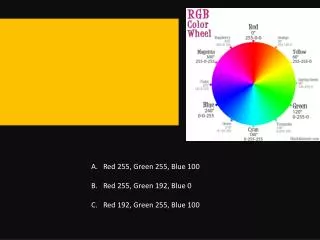
Why RGBs? Visible (VIS0.6) image Exercise 1: where is the dust cloud ?
Visible (VIS0.6) image Dust RGB Product 23 March 2008, 12 UTC EUMETRAIN Module on RGB images: http://www.zamg.ac.at/eumetrain/Seiten/CAL_Topic.htm
MFG VIS Channel Where is snow and where low clouds ?
Low Clouds Snow MFG VIS Channel MSG RGB HRV, NIR1.6 29 July 2004, 09 UTC
RGB Image Composites – Pros & Cons • Drawbacks: • Millions of colours compared to discrete classes used in quantitative image products interpretation more difficult; • Cannot be handled by colour-blind. • Advantages: • Millions of colours: high information content; • Easily implemented; • Preserves “natural look” of images by retaining original textures (in particular for clouds); • Preserves temporal continuity allowing for smooth animation of RGB image sequences.
Standard RGBs RGB Composite Applications Time RGB 10-09,09-07,09: Dust, Clouds (thickness, phase), Contrails Day & Night Fog, Ash, SO2, Low-level Humidity RGB 05-06,08-09,05Severe Cyclones, Jets, PV Analysis Day & Night RGB 10-09,09-04,09: Clouds, Fog, Contrails, Fires Night RGB 02,04r,09: Clouds, Convection, Snow, Fog, Fires Day RGB 05-06,04-09,03-01: Severe Convection Day RGB 02,03,04r: Snow, Fog Day RGB 03,02,01: Vegetation, Snow, Smoke, Dust, Fog Day 1. 2. 3a. 3b. 4. 5. 6.
RGB 03, 02, 01 ("Day Natural Colours") R = Channel 03 (NIR1.6) G = Channel 02 (VIS0.8) B = Channel 01 (VIS0.6) Applications: Vegetation, Dust, Smoke, Fog, Snow Area: Full MSG Viewing Area Time: Day-Time
RGB 03, 02, 01:Interpretation of Colours High-level ice clouds Low-level water clouds Ocean Veg. Land Desert Snow
Ch.03 NIR1.6 Ch.02 VIS0.8 Ch.01 VIS0.6
Ice clouds Water clouds 6 November 2004, 12:00 UTC, RGB NIR1.6, VIS0.8 VIS0.6
RGB 03, 02, 01 Example: Snow MSG-1, 18 February 2003, 13:00 UTC
RGB 03, 02, 01 Example: Vegetation MSG-1, 23 June 2003, 15:00 UTC
RGB 03, 02, 01 Example: Desert MSG-1, 3 February 2004, 11:30 UTC
RGB 02, 04r, 09 ("Day Microphysical") R = Channel 02 (VIS0.8) G = Channel 04r (IR3.9, solar component) B = Channel 09 (IR10.8) Applications: Cloud Analysis, Convection, Fog, Snow, Fires Area: Full MSG Viewing Area Time: Day-Time
Thin Cirrus cloud (large ice particles) Thin Cirrus cloud (small ice particles) Ocean Veg. Land Fires / Desert Snow RGB 02, 04r, 09: Interpretation of Coloursfor High-level Clouds Deep precipitating cloud (precip. not necessarily reaching the ground) - bright, thick - large ice particles - cold cloud Deep precipitating cloud (Cb cloud with strong updrafts and severe weather)* - bright, thick - small ice particles - cold cloud *or thick, high-level lee cloudiness with small ice particles
Ocean Veg. Land Fires / Desert Snow RGB 02, 04r, 09: Interpretation of Coloursfor Mid-level Clouds Supercooled, thick water cloud - bright, thick - large droplets Supercooled, thick water cloud - bright, thick - small droplets Supercooled thin water cloud with large droplets Supercooled, thin water cloud with small droplets * * or, in rare occasions, thin Ci cloud with small ice particles
Ocean Veg. Land Fires / Desert Snow RGB 02, 04r, 09: Interpretation of Coloursfor Low-level Clouds Thick water cloud (warm rain cloud) - bright, thick - large droplets Thick water cloud (no precipitation) - bright, thick - small droplets Thin water cloud withlarge droplets Thin water cloud with small droplets
Example: Cloud Phase ice ice mixed ice water water 8 October 2003, 12:00 UTC, RGB VIS0.6, IR3.9r, IR10.8
Example: Cloud Particle Size Maputo Thick Ice Cloud (large ice) Thick Ice Cloud (small ice) MSG-1, 6 November 2004, 12:00 UTC, RGB VIS0.8, IR3.9r, IR10.8
RGB 02, 04r, 09 Example: Fires MSG-1, 7 September 2003, 11:45 UTC ("winter" enhancement)
RGB 05-06, 04-09, 03-01 ("Convective Storms") R = Difference WV6.2 - WV7.3 G = Difference IR3.9 - IR10.8 B = Difference NIR1.6 - VIS0.6 Applications: Severe Convective Storms Area: Full MSG Viewing Area Time: Day-Time
RGB 05-06, 04-09, 03-01:Interpretation of Colours Deep precipitating cloud (precip. not necessarily reaching the ground) - high-level cloud - large ice particles Deep precipitating cloud (Cb cloud with strong updrafts and severe weather)* - high-level cloud - small ice particles *or thick, high-level lee cloudiness with small ice particles Thin Cirrus cloud (large ice particles) Thin Cirrus cloud (small ice particles) Ocean Land
Thin Ice Cloud (small ice) Maputo Thin Ice Cloud (large ice) Thick Ice Cloud (large ice) Thick Ice Cloud (small ice) MSG-1, 6 November 2004, 12:00 UTC, RGB 05-06, 04-09, 03-01
RGB 05-06, 04-09, 03-01 Example:Severe Convection RGB 02,04r,09 RGB 05-06,04-09,03-01 (for comparison) better identification of young, severe storms MSG-1, 20 May 2003, 13:30 UTC
RGB 05-06, 04-09, 03-01 Example:Severe Convection RGB 02,04r,09 RGB 05-06,04-09,03-01 (for comparison) better identification of young, severe storms MSG-1, 3 February 2004, 11:30 UTC
RGB 05-06, 08-09, 05i ("Airmass") R = Difference WV6.2 - WV7.3 G = Difference IR9.7 - IR10.8 B = Channel WV6.2i Applications: Rapid Cyclogenesis, Jet Stream Analysis, PV Analysis Area: Full MSG Viewing Area Time: Day and Night
Jet (high PV) Cold Airmass Warm Airmass Warm Airmass RGB 05-06, 08-09, 05i:Interpretation of Colours Thick, high-level clouds Thick, mid-level clouds Thick, low-level clouds (warm airmass) Thick, low-level clouds (cold airmass) High UTH Low UTH
RGB 05-06, 08-09, 05i Example: Advection Jet MSG-1, 7 January 2005, 22:00 UTC
RGB 05-06, 08-09, 05i Example: Warm Airmass MSG-1, 7 January 2005, 22:00 UTC
RGB 05-06, 08-09, 05i Example: Cold Airmass MSG-1, 7 January 2005, 22:00 UTC
Standard RGBs RGB Composite Applications Time RGB 10-09,09-07,09: Dust, Clouds (thickness, phase), Contrails Day & Night Fog, Ash, SO2, Low-level Humidity RGB 05-06,08-09,05Severe Cyclones, Jets, PV Analysis Day & Night RGB 10-09,09-04,09: Clouds, Fog, Contrails, Fires Night RGB 02,04r,09: Clouds, Convection, Snow, Fog, Fires Day RGB 05-06,04-09,03-01: Severe Convection Day RGB 02,03,04r: Snow, Fog Day RGB 03,02,01: Vegetation, Snow, Smoke, Dust, Fog Day 1. 2. 3a. 3b. 4. 5. 6.
Contributors HP. Roesli (EUM), D. Rosenfeld (Israel), M. Setvak (CZ), M. König (EUM), G. Bridge (EUM), E. De Coning (RSA), Eronn (Sweden), K. Kollath & M. Putsay (Hungary), H. Kocak (Turkey), J. Schipper (Austria), V. Nietosvaara (EUM), S. Gallino (Italy), P. Santurette (France), C. Georgiev (Bulgaria)
