Dynamic Heights from GNSS
190 likes | 213 Vues
Learn about the NGS 10-year and strategic plans for GNSS dynamic heights at INTERGEO Berlin. Understand the shift to NATRF2022 and CTRF2022, modernizing NSRS and more. Evaluate geopotential models for accurate heights.

Dynamic Heights from GNSS
E N D
Presentation Transcript
Dynamic Heights from GNSS Daniel R. Roman, Ph.D. Chief Geodesist
NGS Vision Everyone accurately knows where they are and where other things are anytime, anyplace. NGS 10 Year and Strategic Plans provide a more detailed description of NGS and the vision for the future looking ten years out. INTERGEO Berlin, Germany 26-28 September 2017
Replace NAD 83 Simplified concept of NAD 83 vs. “2022” Earth’s Surface h”2022” hNAD83 fNAD83 – f”2022” lNAD83 – l”2022” hNAD83 – h”2022” all vary smoothly by latitude and longitude “2022” origin ~2.24 m NAD 83 origin INTERGEO Berlin, Germany 26-28 September 2017
Vertical Shifts Ellipsoidal Orthometric INTERGEO Berlin, Germany 26-28 September 2017
NSRS Modernization The New: The North American Terrestrial Reference Frame of 2022 (NATRF2022) The Caribbean Terrestrial Reference Frame of 2022 (CTRF2022) The Pacific Terrestrial Reference Frame of 2022 (PTRF2022) The Mariana Terrestrial Reference Frame of 2022 (MTRF2022) The Old: NAD 83(2011) NAD 83(PA11) NAD 83(MA11) INTERGEO Berlin, Germany 26-28 September 2017
NSRS Modernization The Old: NAVD 88 PRVD 02 VIVD09 ASVD02 NMVD03 GUVD04 IGLD 85 IGSN71 GEOID12B DEFLEC12B Orthometric Heights The New: The North American-Pacific Geopotential Datum of 2022 (NAPGD2022) - Will include GEOID2022 Normal Orthometric Heights => International Great Lakes Datum of 1985 Dynamic Heights Gravity Geoid Undulations Deflections of the Vertical INTERGEO Berlin, Germany 26-28 September 2017
HC vs. NAVD 88 Datum Defect INTERGEO Berlin, Germany 26-28 September 2017
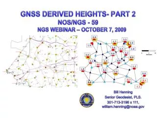
GL WLS Stations INTERGEO Berlin, Germany 26-28 September 2017
Method Geometric coordinates of water surface Inverted rod CORS Antenna WLS Housing ETG Receiver ETG Table (datum) Great Lake leveling BM IGLD 85 Datum surface INTERGEO Berlin, Germany 26-28 September 2017
Conceptual Plan • Each Lake surface conforms to a specific geopotential value (Wi) and dynamic height C3 C2 C1 DH3 = W0 – W3 gamma45 DH2 = W0 – W2 gamma45 DH1 = W0 – W1 gamma45 C0 (geoid) ellipsoid Notes: (1) Neglects any standing water topography (wind set) (2) Assumes sufficient resolution of geopotential number INTERGEO Berlin, Germany 26-28 September 2017
Practical Aspects • Need 1’ resolution(1) (d/o 10,800) SHM • Only have 5’ resolution (2) (d/o 2160) SHM plus 1’ geoid grid W(5’)g(5’) C3 C2 C1 N (5’) N (1’) C0 (geoid) ellipsoid Notes: (1) Previous analysis shows that omission from > 1’ resolution exceeds cm-level (2) xGEOID16B available at https://beta.ngs.noaa.gov/GEOID/xGEOID16/ (3) W0 by is defined as 62,636,856.00 m2/s2 INTERGEO Berlin, Germany 26-28 September 2017
INTERGEO Berlin, Germany 26-28 September 2017
Method • Ideally, use 1’ reference model – degree 10,800 • Only 5’ models available • To approximate: • NPfrom final geoid (1’) • NP from ref. model (5’) • WP from ref. model (5’) • Pfrom ref. model (5’) • First is from xGEOID16B • Rest from xGEODI16B_Ref Use residual geoid to approximate residual geopotential value: = – W0 = - * = + = /γ45 Note that approximates INTERGEO Berlin, Germany 26-28 September 2017
Geometric Coordinates of WS (CORS) INTERGEO Berlin, Germany 26-28 September 2017
Geopotential Model-Derived Heights (CORS) INTERGEO Berlin, Germany 26-28 September 2017
Geometric Coordinates of WS (Campaign GPS-Canadian solution) * Latitude/longitude are from hand held GPS at WLS station – height transferred from BM INTERGEO Berlin, Germany 26-28 September 2017
Geopotential Model-Derived Heights (Campaign GPS-Canadian solution) INTERGEO Berlin, Germany 26-28 September 2017
Summary • Dynamic Heights can be derived from a geopotential model and GNSS • A one arc-minute model would be ideal • Otherwise, approximations are required • CORS better than campaign GPS • Further evaluation awaits final adjustment of GPS campaign data • Water topography issues still remain INTERGEO Berlin, Germany 26-28 September 2017
Questions? Daniel R. Roman Chief Geodesist National Geodetic Survey INTERGEO Berlin, Germany 26-28 September 2017