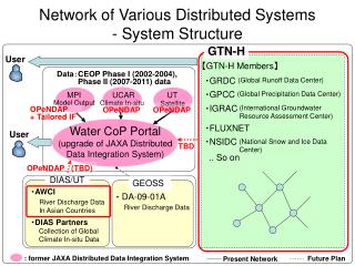
Download
1 / 44
440 likes | 467 Vues
Discover the pivotal role of ocean observations in NOAA's mission, global partnerships, societal benefits, and future goals for climate and marine systems. Learn about the crucial components and collaborative efforts driving the progress of the Global Earth Observation System. From moored buoys to satellite missions, explore the comprehensive approach to monitoring and managing oceanic data for diverse applications. Join the journey towards a more informed and sustainable future through enhanced ocean observations.

E N D
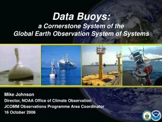
Data Buoys:a Cornerstone System of theGlobal Earth Observation System of Systems Mike Johnson Director, NOAA Office of Climate Observation JCOMM Observations Programme Area Coordinator 16 October 2006
Ecosystems Weather & Water Commerce & Transportation Climate 1) Ocean observations are critical to NOAA’s mission NOAA’s Mission Goals
2) International cooperation is crucial to our success. NOAA is committed to strengthening partnerships. Indonesia partnership with USA: Capacity Building Workshop (sponsored by WMO): “The Use of Ocean Observations to Enhance Sustainable Development” in exchange for ship support to deploy moored buoys in the Indian Ocean
3) Ocean observations add value to society GOOS GEOSS Societal Benefits
Capabilities Requiredto build the Ocean component of GEOSS: • Global coverage by moored and drifting buoy arrays, profiling floats, tide gauge stations, and ship-based systems. • Continuous satellite missions for sea surface temperature, sea surface height, surface vector wind, ocean color, and sea ice. • Data and assimilation subsystems • System management and product delivery
The Road Map • Implement the ocean domain of GCOS-92: • International GOOS • GEOSS Ocean Baseline • UNFCCC Priority • G8 Commitment Objective Observations Programme Area
GCOS-92 Implementation Targets are designed for climate but also serve global weather prediction, global and coastal ocean prediction, marine transportation, marine hazards warning, marine environmental monitoring, and many other non-climate users. • Tide gauge stations • Drifting Buoys • Tropical Moored Buoys • Profiling Floats • Ships of Opportunity • Ocean Reference Stations • Ocean Carbon Networks • Arctic Observing System • Dedicated Ship Support • Data & Assimilation Subsystems • Management and Product Delivery • Satellites -- SST, Surface Topography, Wind, Color, Sea Ice
The organizing framework is in place All six global (in situ) implementation programs are now linked internationally through WMO/IOC JCOMM coordination
The DBCP: a leader and model for GOOS implementation • The DBCP model: • Shared benefits -- individual national contributions result in a global data set for use by all • Shared responsibility -- a self supporting panel • Regional Action Groups • Technical Coordinator and platform support center • Promoting science, technology development, and user feedback • Looking to the future
Ceremony celebrating the DBCP’s completion of the global drifter array during JCOMM-II, September 2005. • “The coordination of a GEOSS, will rely on the same kind of shared vision and commitment that we are celebrating today.” • Marc Denis Everell, Assistant Deputy Minister, Meteorological Service of Canada
The Success of JCOMMOPS:Looking to the Future • Roundtable, May 2006: representatives from the OCG, DBCP,SOT, GLOSS, Argo, OceanSITES, IOCCP, POGO • The need to evolve toward a Global Observing Program Support Center was agreed. • Estimate seven personnel needed versus the present two working at JCOMMOPS. • Shared benefit, shared responsibility: the Systems benefiting should pay in proportion to their demand for JCOMMOPS services. • Possible relocation of JCOMMOPS to an operational center that might furnish in-kind contributions and additional support. • Some centers have already expressed interest informally. • Management Committee (07 October, Geneva): OCG will develop requirements/specifications for future JCOMMOPS evolution and call for proposals.
Initial Global Ocean Observing System for ClimateStatus against the GCOS Implementation Plan and JCOMM targets 56% October 2006 Total in situ networks 57% 100% 42% 81% 81% 43% 66% 21% 48% • A total of 5635 platforms are • maintained globally. • Of these, 1660 are data buoys.
Surface Drifting Buoys 1250 sustained array (achieved) • Users Workshop (March 2006) • Implement hourly reporting • Need barometers on all drifters • (presently 385)
Surface Drifting Buoys: Good news from Europe
[The DBCP now supplies 30 Hurricane Drifters per year]Drifting Buoys Deployed in Hurricane Rita20 buoys measure air pressure, SST, wind speed & direction8 buoys measure upper ocean temperature Pressure vs. Distance from Center of Rita Wind Direction Data on Plot of Drifter Location Relative to Rita Center Forecast Track NOAA Hurricane Drifters ready for air deployment by the Hurricane Hunter Squadron at Keesler AFB Courtesy of Scuba (2006)
Tropical Moored Buoys PIRATA extensions and Indian Ocean Array
UK • RAPID continuation • USA • Transition from NSF to NOAA: Indonesian Through Flow • Transition from Germany to NOAA: MOVE array • New NOAA: California Current real time monitoring • Australia • New Observatory • USA • Ocean Observatories Initiative • Nine new sites: 2007-2012
Measuring Ocean Carbon Sources and Sinks New carbon systems on NDBC Coastal Weather Buoys • 1. Inventory 10-year survey • 2. Ships of opportunity • 3. Moored buoy time series 38% complete
PX38 AX03 AX10 AX07 PX37 PX40 AX20 PX44 PX10 AX34 AX11 PX18 PX21 PX09 PX31 PX11 IX10 PX04 AX29 PX05 PX13 IX08 PX17 AX15 IX09S IX07 IX06 PX02 AX08 IX01 IX22 PX81 IX12 PX30 PX08 PX06 IX21 IX15 PX50 AX18 PX34 AX25 IX28 AX22 PX36 Well sampled Over sampled Partially sampled Under sampled Not sampled HDX Not sampled FRX • JCOMM-II Recommendation 3: • Establish a JCOMM Trust Fund for consumables. • WMO has agreed to manage the Trust Fund. • Trust fund expenditures to be authorized by the Chair of SOT. Note : AX08 is Under sampled in FRX Mode SOOP: 39 of 51 lines now occupied
GCOS Climate Reference Network of Tide Gauge Stations By the end of 2007 most of the 170 Climate Reference Tide Gauge Stations Will Provide Marine Hazards Warning in Real Time
Observing Mapping Modeling New Challenge for GOOS and the DBCP: Implementing the Tsunami Warning Buoy (Tsunameter) system 19 DART stations operational USA contribution
Integrating tsunami buoys into GOOS Chilean Tsunami Buoy being deployed during a U.S. Climate mission Met sensors will be installed by USA on the Chilean tsunami buoy in October 2006 Sites where Tsunami and Climate plans overlap -- potential for coordination Sites where Climate missions already deploy tsunami buoys routinely
Observing System Monitoring Center(OSMC)A new tool for monitoring the observing system in near real timeHosted by NOAA on behalf of JCOMM
Beta version of the OSMC is available for JCOMM test and evaluation.
Sort by: • Platform type • Variables being sampled • Time frame • Contributing Country
Drill down for platform metadata and real-time data reports. Database operations at NOAA NDBC. Hold data for 5 years. Updated daily. Data source -- GTS via the GODAE server system at Navy Monterey. Other web sources are being added.
LAS -- GIS specially designed for observing system managers (by NOAA PMEL) Viewer Options: ESRI -- commercial GIS tool Google Earth -- open source GIS with great graphics, fun for kids (and adults)
1252 Drifting Buoys reporting yesterday
385 Drifting Buoys reporting barometric pressure
18 Drifting Buoys reporting wind
396 Moored Buoys reporting yesterday
819 Ships reporting two days ago Location security: Ship observations are not available for the most recent 48 hours.
2334 Argo Floats reporting during the past month
Japan had 352 Platforms reporting during the past month
Canada had 155 Platforms reporting during the past month
Australia had 123 Platforms reporting during the past month
Tide Gauge Stations o GLOSS o Climate Reference Stations o Real Time Reporting o Geocentrically Located o NWLON Drifting Buoys o High Seas Drifters o Barometer Drifters o Wind Drifters o Hurricane Drifters o Ice Buoys Moored Buoys o Weather Buoys o Tsunami Warning Stations o Tropical Moored Buoys o Climate Reference Stations o Ocean Carbon Stations o Ecosystem Monitoring Buoys Profiling Floats and Gliders o Argo Profilers o Gliders Initial design for sorting by Platform Ships o Volunteer Observing Ships VOSClim Weather Obs Weather and Ocean Obs Ocean Carbon Obs o Dedicated Ships Ecosystem Monitoring Charting Surveys Climate Monitoring (SAMOS) Ocean Carbon Surveys Platform support Research Ocean Transport Stations o Moored arrays o Cable Measurements Shore and Bottom Stations o C-MAN Weather Stations o PORTS Systems o Seismic Monitoring Stations Satellites
Test Version 2.00 beta: www.jcommops.org/network_status Feedback: opa@jcommops.org
Data Buoys: A Cornerstone System of the Global Earth Observation System of Systems
Thank You, DBCP photo courtesy of MeteoFrance
Data Buoys:a Cornerstone System of theGlobal Earth Observation System of Systems Data Buoy Cooperation Panel La Jolla, 16 October 2006 Mike Johnson JCOMM Observations Programme Area Coordinator photo courtesy of MeteoFrance