CONTROLLERS WORKSHOP 6 October 2011 Canberra
200 likes | 235 Vues
Learn about map specifications, symbol explanation, field checking, and generalization for orienteering events. Understand international and Australian rules in course mapping development.

CONTROLLERS WORKSHOP 6 October 2011 Canberra
E N D
Presentation Transcript
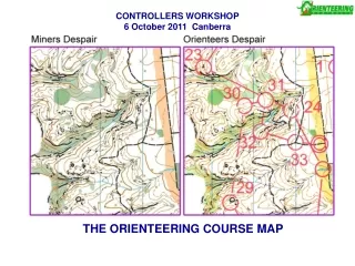
CONTROLLERS WORKSHOP6 October 2011 Canberra THE ORIENTEERING COURSE MAP
Controllers Workshop - The orienteering course map 1 Introduction 2 General requirements of a map 3 Map specifications 4 Explanation of symbols 5 Field checking 6 Checklist for controlling the map making process 7 Map deviations 8 Other considerations 9 Summary 10 Tasks
Controllers Workshop - The orienteering course map 1 Introduction 1.1 Fairness A standardised map is the basis for orienteering as an international event a map with deviations = unfair competition “It’s important to maintain the integrity and credibility of the sport and it’s based on rules” Nick Davies, Director IAAF, in reference to Usain Bolt being disqualified for a false start in the 100m final at the World Athletics Championships, August 2011
Controllers Workshop - The orienteering course map 1 Introduction 1.2 Rules applying to orienteering maps International Rules Competition Rules for IOF Foot orienteering Events 2011 Section 15. Maps Appendix 6. Competition Format - Map scales International Specifications for Orienteering Maps 2000 (ISOM2000) International Specifications for Sprint Orienteering Maps 2007 (ISSOM2007) International Specifications for Mountain Bike Orienteering Maps 2010 (ISMTBOM2010) International Specifications for Ski Orienteering Maps 2009 (ISSkiOM2009) Check list for controlling the map making of major IOF events Guidelines for using non-offset printed maps in World Ranking Events IOF PrintTech test sheet – spot colour, off set printed test sheet IOF Control Descriptions 2004 Guidelines for World Ranking Events Section 10. Model Event Section 11. Map
Controllers Workshop - The orienteering course map 1 Introduction 1.2 Rules applying to orienteering maps Australian Rules Competition Rules for Orienteering Australia Foot Orienteering Events Section 15. Maps Section 17. Restricted areas and routes Section 18. Control descriptions OA Operational Manual Section 2.9. Mapping of Rock Features Section 2.10. Mapping - Digital Printing Policy
Controllers Workshop - The orienteering course map 1 Introduction 1.3 Development of ‘O maps’ and influencing technology 1897 First public event, in Norway 1900-1950 Small scale topographic maps used, 1:100,000 to 1:50,000 1928 Invention of orienteering compass 1948 Maps drawn specifically for orienteering • 1:25,000 1960’s Photocopiers • ISOM69 1:25000, use of standard symbols 1972 Concept of ‘runability’ • ISOM75 1: 20000 1970’s Laser printers and copiers 1978 First contour base map in Aust using a stereoplotter / analog machine 1982 ISOM82 1: 15000 1988 Inkjet printer $1000 • ISOM90 1:15000 1990’s Digital cartography ie OCAD, colour photocopiers & printers, Laser jet printer (600dpi) 2000 ISOM2000 1:15000, 1:10000 for non elites, Sprint O at 1:5000, MTBO 2000’s Digital photogrammetry, digital aerial photography 2005 GPS, Airborne Laser Scanning (LIDAR), Google Earth (aerial and satellite photographs) 2007 ISSOM2007 1:5000/4000 2008 ‘Nearmap’ – high resolution (to 2cm) digital aerial photographs • ISMBTOM2010 The future? Automatic derivation of symbols from laser scanning? 3-D maps?
Controllers Workshop - The orienteering course map 1 Introduction 1.3 Development of ‘O maps’ and influencing technology
Controllers Workshop - The orienteering course map 2 General requirements 2.1 Orienteering and the map • The map must give a picture of the terrain
Controllers Workshop - The orienteering course map 2 General requirements 2.2 Content • The map must contain features which: • are obvious on the ground to a competitor at speed and, • features that influence route choice ‘running navigation’
Controllers Workshop - The orienteering course map 2 General requirements 2.3 Accuracy • a competitor should not perceive any inaccuracy in the map • spatial and height accuracy • relative and absolute accuracy • maps should now be georeferenced normally World Geocentric System 1984 which is virtually identical to Geocentric Datum of Aust 1994 Control 24? Correct location on map Correct location in field Map distortion Relative location Absolute location GPS tracking now requires a higher level of map accuracy
Controllers Workshop - The orienteering course map 2 General requirements 2.4 Generalisation and legibiltiy • The Controller may need to advise the level of detail to be mapped • The map must be legible and easy to interpret at running speed • The need for GENERALISATION to aid map LEGIBILITY: • “a few well drawn features are better than a lot of small detail that may clutter the map or disguise the shape of the landform” • Eduard Imhof, Swiss cartographer
Controllers Workshop - The orienteering course map 2 General requirements 2.4 Generalisation and legibiltiy • There are two phases of generalisation (1) Selective generalisation – ‘what is to be mapped’ “Maps get more and more detailed. I don’t know if this is the right way to go, but it is a fact.”Thierry Gueorgiou Dec 2007
Controllers Workshop - The orienteering course map 2 General requirements 2.4 Generalisation and legibiltiy (2) Graphic generalisation – ‘how it is to be drawn’
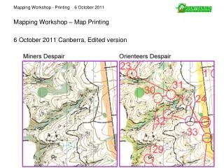
Controllers Workshop - The orienteering course map 2 General requirements 2.4 Generalisation and legibiltiy • Generalisation or ‘smoothing’ of LIDAR contours in the field by the mapper is essential
Controllers Workshop - The orienteering course map 3 Map specifications 3.1 Scale • Terrain that cannot be legibly presented at a scale of 1:15000 is not suitable for foot orienteering Long distance 1:15000, 1:10000* with approval** for elites 1:10000* for < M/W16 and >M/W40 Middle distance 1:15000, 1:10000* Relay 1:15000, 1:10000* Sprint 1: 5000 or 4000 *A 1:10000 map is a strict enlargement of a 1:15000 map **Approval is needed for M/W Elite junior & senior and M/W 17-39A in the Australian Championships to use a scale other than 1:15000
Controllers Workshop - The orienteering course map 3 Map specifications 3.2 Contour interval • Standard is 5m interval. In flat terrain 2.5m may be used. • Form lines: only one form line between contours there is a tendency to over use form lines
Controllers Workshop - The orienteering course map 3 Map specifications 3.3 Dimensions of map symbols • Certain minimum dimensions must be respected to aid legibility
Controllers Workshop - The orienteering course map 3 Map specifications 3.3 Dimensions of map symbols • Certain minimum dimensions must be respected to aid legibility
Controllers Workshop - The orienteering course map 3 Map specifications 3.3 Dimensions of map symbols • OCAD can measure areas & lengths • Controller can easily check compliance to minimum dimensions
Controllers Workshop - The orienteering course map 3 Map specifications 3.4 Enlargement of maps • A 1:10000 scale map is a strict enlargement of a 1:15000 scale map Why? 1:15000 considered a good compromise between the conflicting requirements of map reading for fine navigation & for route choice. Larger map scales will lead to more map detail (ie less generalisation) and larger size maps for Long distance races. More detail requires more simplification by the orienteer and will slow down the running speed. Standard scales are 1:15000 and 1:5000/4000.