Download
1 / 1
20 likes | 103 Vues
COMPARISON OF CO MIXING RATIOS AT A PRIMARY FOREST AND MAXARANGUAPE SITES. 1 Boian, C., 1 Kirchhoff, V.W.J.H., 2 Munger, W., 2 Wofsy, S.C. and 3 Saleska, S.R. 1 Instituto Nacional de Pesquisas Espaciais – INPE 12201-970 – São José dos Campos, São Paulo, Brazil boian@dge.inpe.br

E N D
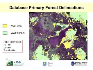
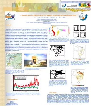
COMPARISON OF CO MIXING RATIOS AT A PRIMARY FOREST AND MAXARANGUAPE SITES 1Boian, C., 1Kirchhoff, V.W.J.H., 2Munger, W., 2Wofsy, S.C. and 3Saleska, S.R. 1Instituto Nacional de Pesquisas Espaciais – INPE 12201-970 – São José dos Campos, São Paulo, Brazil boian@dge.inpe.br 2Harvard University – Division of Engineering and Applied Science/Department of Earth and Planetary Science 3University of Arizona ABSTRACT This work describes a comparison of CO mixing ratios at a forest site, Santarém km 67 (3S; 54.5W) and a typical region of Brazil (Maxaranguape, 5.8S; 35.2W). One year of almost continuous CO measurements, convering entire periods of the dry and wet season, are described for both sites. These CO measurements are part of the Large Scale Biosphere-Atmosphere Experiment in Amazonia (LBA). The mixing ratios obtained at Santarém are always larger than those obtained at Maxaranguape. For example, for a typical month of the wet period (April), the CO average was 86.48.6 ppbv, at Santarém and 51.1 9.2 ppbv at Maxaranguape. As expected, a clear increase in CO mixing ratios was observed during the dry season, however, this period peaks in September/October for Maxaranguape and the south regions, whereas it peaks in November at Santarém. Thus at Santarém, the highest CO mixing ratios were obtained in November (317202 ppbv), whereas at Maxaranguape they were 50.110.5ppbv in November (and 59.8 16.1 ppbv in September). It is also noticeable that the seasonal amplitude of variation is much larger at Santarém than at Maxaranguape. Backward trajectories obtained to determine the origin of air Parcels reaching Santarém, show predominance of origin from north-east regions. Thus in addition to the high density of local fires in the Santarém area in November, the arriving air parcels have traveled many days over areas of intense burning. A set of five days backward trajectories for Maxaranguape site, during November 1-30, 2001, showing that the lower altitude air parcels have a tendency to come from the ocean (pristine air). Variability of fire pixels in Santarém (PA) over the years 1999 to 2002. The distribution of fire pixels over the year is also quite irregular, but always more packed, from August to November (dry season). A set of five days backward trajectories for the Santarém site (ST), during April (10, 20, 30), 2002; showing that the lower altitude air parcels have a tendency to come from the equatorial north-east of region Brazil. For each day were calculated four trajectories at different isentropic surface. Map of Brazi l showing fire pixels (AVHRR, NOAA 12 satellite) during April 2002. There were pratically no fire pixels for the equatorial north-east regions this month. The Maxaranguape station (5.8S; 35.2W) where the CO mixing rations were measured. A partial map of the Santarém region showing the location of the site where the CO measurements where made (km 67 Primary Forest Tower Site). A set of five backward trajectories for the Santarém site (ST), during November, 2002, showing that the lower altitude air parcels have a tendency to come from the equatorial north-east of region Brazil (as was the case For April). Map ofBrazil showing fire pixels (AVHRR, NOAA 12 satellite), during November 2002. In contrast, there is now considerable fire activity in the north-east region (states of Pará – PA; Maranhão – MA; Piauí – PI; Ceará – CE. CONCLUSIONS Comparison of CO averages obtained around noon local time (10 and 14 LT) between the Santarém (forest) and Maxaranguape (marine) sites, for the year 2002. Santarém shows higher values. The mixing ratios obtained at Santarém are always larger than those obtained at Maxaranguape. the highest CO mixing ratios in Santarém were measured during November. It was also observed a large variation in CO mixing ratios measured during this period, showing a heterogeneous troposphere under the interaction of different air parcels compositions. According to fire pixels from AVHRR on satellite NOAA 12, during this period, the north (equatorial) region of Brazil shows significant (late) fire activity, concentrated around low equatorial latitudes, and extending from the Amazon forest area to the coastal region. Simultaneous observations of the backward air parcel trajectories showed that in addition to local production, some of the high CO mixing ratios measured during the dry season in Santarém are associated with large-scale transport from the north-east region. ACKNOWLEDGMENTS FAPESP LBA/NASA HARVARD UNIVERSITY INPE MAXARANGUAPE TEAM