Download
1 / 33
340 likes | 597 Vues
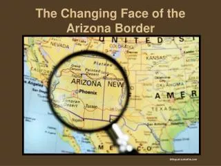
The Changing Face of the Arizona Border. bilingual.suleckha.com. Dennis Rees Teacher-Consultant Arizona Geographic Alliance. How the border between Arizona and Mexico looked has changed over time. The following pictures show that evolution.

E N D
The Changing Face of the Arizona Border bilingual.suleckha.com
Dennis Rees Teacher-Consultant Arizona Geographic Alliance
How the border between Arizona and Mexico looked has changed over time. The following pictures show that evolution.
As you view the images, what changes to the border do you see? What do you think caused these changes? How do you think the border will change in the future?
In 1915, the border at Douglas, Arizona, looked like this. 1-22infantry.org
Today, this is what it looks like. flicker.com flicker.com
wn.com kvoa.com
This is Naco, Arizona, in 1917. knet.asu.edu
Here it is today. flicker.com flicker.com
In the 1980’s, the crossing at Lochiel, Arizona, was closed. wikipedia.com
It looked like this in the summer of 2000. Dennis Rees
This is how it looks today. flicker.com
Nogales, Arizona, one of the older border crossings, looked like this in 1899. cdlib.org
Here is what it looked like in the 1910s. arizona100.blogspot.com
Today, it looks like this. flicker.com
Lukeville, Arizona, a popular border crossing for people headed to Puerto Penasco, Sonora, looked like this in 2000. Dennis Rees
Today, it looks like this. vagabonder-supreme.net
Sasabe, Arizona, is another border crossing. It once looked like this. flicker.com
Today, it looks like this. flicker.com americanpatrol.com
San Luis is the westernmost Arizona-Mexico border crossing. Established in 1930, it quickly became a agricultural, manufacturing, and retail business center for the area.
Today, it looks like this. mappingmainstreet.org
panoramio.com time.com
Now that you have seen the border over the years, what changes did you see? What do you think caused these changes? How do you think it will change in the future?
Photograph and Image Credits Slide 1: bilingual.suleckha.com Side 5: 1-22 infantry.org Slide 6: flicker.com Slide 7: wn.com kvoa.com Slide 8: tucsoncitizen.com Slide 9: knet.asu.edu Slide 10: flicker.com Slide 11: tucsonsentinal.com Slide 12: wikipedia.org Slide 13: Dennis Rees, AzGA Borderlands Institute 2000 Slide 14: flickr.com Slide 16: cdlib.org Slide 17: arizona100.blogspot.com Slide 18: flicker.com Slide 19: nogalesinternational.com Slide 20: latindispatch.com Slide 22: Dennis Rees, AzGA Borderlands Institute 2000
Slide 23: vagabonder-supreme.net Slide 24: environmentmagazine.org Slide 25: flicker.com Slide 26: flicker.com americanpatrol.com Slide 27: LIFE photo archive Slide 29: mappingmainstreet.org Slide 30: panoramio.com time.com