The Earth’s Shifting Crust
140 likes | 323 Vues
Chapter 11. The Earth’s Shifting Crust. The Quaking Earth. Earth’s surface is constantly moving An earthquake happens somewhere on Earth about every three minutes An Earthquake is a sudden release of energy that occurs when rocks shift in the Earth’s crust

The Earth’s Shifting Crust
E N D
Presentation Transcript
Chapter 11 The Earth’s Shifting Crust
The Quaking Earth • Earth’s surface is constantly moving • An earthquake happens somewhere on Earth about every three minutes • An Earthquake is a sudden release of energy that occurs when rocks shift in the Earth’s crust • A Fault is a line of weakness in the rocks of the Earth’s crust
The Quaking Earth (cont.) • In Canada, the greatest earthquake danger is in British Columbia • BC is a region that is crossed by many faults
What causes Earthquake? • They occur when the Earth’s plates grind past one another • The jagged rocks of the crust become locked together and only snap free when the pressure to move builds up • A tsunami is cause when the earthquake shakes the ocean floor • Sometimes a tsunami can cause more damage than the earthquake
Locating and Measuring Earthquakes • Seismographs are used to measure the beat of the Earth • The pen on the seismograph jumps as it records the shock waves created by an earthquake • The epicentre is the point below the Earth’s surface where energy is released as pieces of rock move to new positions along a fault
Locating and Measuring Earthquakes (cont.) • To pinpoint the epicentre • Scientists calculate how far the shock waves travelled to reach three nearby seismograph stations • Next they draw circles of this radius • Find the point where they all meet
Locating and Measuring Earthquakes (cont.) • Richter scale is used to measure the intensity of the earthquake • Richter scale is based on a 10 point system • Scale of 5 is one tenth as strong as 6
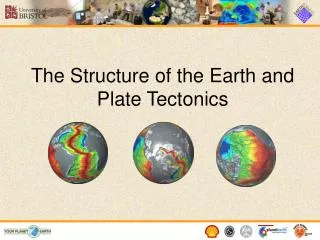
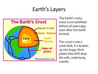
Understanding the Movements of the Earth • Surface of the Earth is constantly changing • Fold mountains heave upwards, volcanoes erupt, earthquakes shatter solid rock and faults open in the Earth’s crust • Many mountains, volcanoes, earthquakes, and faults occur around the edges of the Pacific Ocean and in a band across Asia and Europe
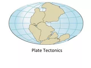
Continental Drift • A theory developed by Alfred Wegener • To explain the landform pattern of Earth • Theory suggests that land masses move slowly over the Earth’s surface • Does not explain what causes them to move • Not accepted by scientist because they believed the Earth was solid right through to the centre
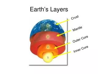
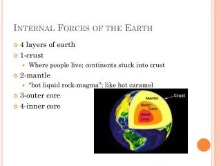
Plate Tectonics • Convection currents is when the plates on the Earth’s crust are slowly dragged together, apart, or sideways by the rolling motions of molten rock in the mantle • The mantle is the semi-liquid layer that lies just beneath the crust • Plate tectonics theory suggests that this plate movement creates landform pattern both on land and beneath the ocean
Plate Tectonics and Landform Pattern • The ocean floor is not flat • It contains long, narrow trenches, and mountains • There are as mountains under the ocean as above the ocean on land • Oceans are shallowest in the middle and deepest around the edges • The above things occur when the Earth’s plates move together or apart
When Plates move Apart • Two plates of the Earth’s curst are moving apart in the middle of he Atlantic Ocean at an average rate of about 3 cm per year • The molten rock that pours through the gap has built underwater mountain chain that circles the Earth • Along the ridge new volcanic islands emerge
When Plates move Together • Around the edges of the Pacific Ocean are deep ocean trenches • Ocean trenches are long, narrow, and deep grooves in the ocean floor formed when an oceanic plate has been pulled under a continental plate • The whole range of landform building activity occur here: fold mountains, volcanoes, earthquakes, and faults
When Plates move Together (cont.) • The edges of the Pacific Ocean are the most active regions on Earth • Fold mountains are created as the ocean floor slowly buckles and bends upwards • Deep trenches form as the ocean plate is hauled under the continent • The ocean plate grinds and lock against the underside of the continent, causing regular earthquakes • The earthquakes shatter the crust, causing faults and cracks • The ocean plate melts as it is dragged into the mantle and molten rock moves up through the fault which results in the Pacific Ring of Fire