Download
1 / 8
80 likes | 262 Vues
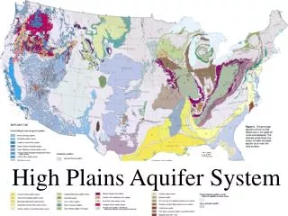
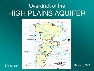
Overdraft of the HIGH PLAINS AQUIFER. Eric Bueser. March 3, 2010. Overview. Officially known as the Ogallala Aquifer Occupies an 8-state region in the central United States Underlies 174,000 square miles of land in those states Unconfined – all recharge comes from rainwater and snowmelt

E N D
Overdraft of theHIGH PLAINS AQUIFER Eric Bueser March 3, 2010
Overview • Officially known as the Ogallala Aquifer • Occupies an 8-state region in the central United States • Underlies 174,000 square miles of land in those states • Unconfined – all recharge comes from rainwater and snowmelt • Composed primarily of unconsolidated clay, silt, sand, and gravel.
Water Usage • Originally tapped for irrigation in 1911 – large-scale use began in the 1950s • Nearly 13.6 million acres of land are irrigated by the aquifer • About 27% of the irrigated land in the U.S. overlies this aquifer • Responsible for 30% of all groundwater used in irrigation • Provides drinking water for 82% of the population living with the boundaries of the aquifer
Overuse • USGS estimated total water storage in 2005 to be roughly 3,608 cubic km • This is a decrease of about 312 cubic km (9%) since major ground-water irrigation began in the 1950s • Estimates peg total depletion of the aquifer in as little as 25 years all the way to 100 years • Graph shows water level fluctuations in the aquifer.
Recharge & Overdraft • Recharge comes mainly from rainwater and snowmelt. Semi-arid climate results in extremely low recharge of the aquifer: levels range from .02 inches in parts of Texas to around 6 inches in parts of Kansas, with an overall High Plains average of less than an inch • Through the end of the last decade, overdraft was occurring at a rate of nearly three feet per year • Western Kansas, eastern New Mexico, northern Texas among areas where overdraft is greatest. • Nebraska and central Texas actually have seen increases in the water level
Where is all the water? • The specific yield for the aquifer is .15, which means 85% of the aquifer’s water is locked up in the unsaturated zone and inaccessible • Attempts are being made to force water from the unsaturated zone into the saturated zone. One experiment involves injecting air into the unsaturated zone, permitting movement of water down to the saturated zone • Positive results locally, but widespread implementation of the technology has not been shown to be effective.
Conservation • Originally, unlined ditches and hand-moved sprinkler systems resulted in losses of 10-50% to evaporation and percolation • Center pivot sprinkler systems are 95% efficient and underground drip systems are nearly 100% efficient • Water usage has declined from almost 5 feet per year to around 3 since the 1950s and 1960s, but still only 1% of the water is replenished every year • Current focus is more towards “effective” depletion rather than ultimate conservation
References • http://www.waterencyclopedia.com/Oc-Po/Ogallala-Aquifer.html • http://www.hpwd.com/images/hp_nawqa.gif • http://en.wikipedia.org/wiki/Ogallala_aquifer • http://upload.wikimedia.org/wikipedia/commons/archive/3/3b/20090224182254!Ogallala_area_freshwater_ground_withdrawals_all_aquifers.png • http://www.hpwd.com/the_ogallala.asp • http://shipbright.files.wordpress.com/2009/10/ogallala_aquifer17.jpg • http://www.waterencyclopedia.com/images/wsci_03_img0398.jpg