Download
1 / 1
10 likes | 70 Vues
The Study of Wind Streaks Associated with Hale Crater Zahra Hirji, GE 132, December 9, 2008 Department of Geological Sciences, Brown University. 1. 4. 5. Introduction. Results. Methods. Wind Streak Distribution. Wind Streak Distribution:.

E N D
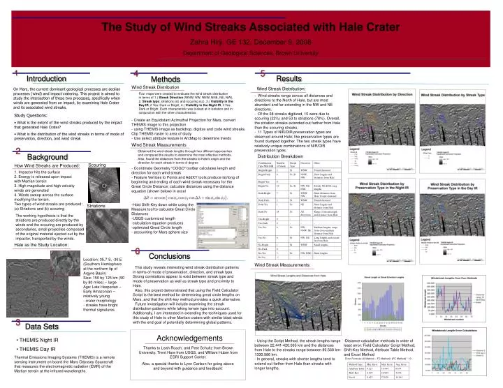
The Study of Wind Streaks Associated with Hale Crater Zahra Hirji, GE 132, December 9, 2008 Department of Geological Sciences, Brown University 1 4 5 Introduction Results Methods Wind Streak Distribution Wind Streak Distribution: On Mars, the current dominant geological processes are aeolian processes (wind) and impact cratering. This project is aimed to study the intersection of these two processes, specifically when winds are generated from an impact, by examining Hale Crater and its associated wind streaks. Four maps were created to evaluate the wind streak distribution in terms of 1.) Streak Direction (WNW, NW, NNW, NNE, NE, NW), 2. Streak type: striations (st) and scouring (sc), 3.) Visibility in the Day IR, if Yes: Dark or Bright, 4.) Visibility in the Night IR, if Yes: Dark or Bright. Each characteristic was looked at in isolation and in conjunction with the other characteristics. - Wind streaks range across all distances and directions to the North of Hale, but are most abundant and far-extending in the NW and NE directions. - Of the 68 streaks digitized, 15 were due to scouring (22%) and 53 to striations (78%). Overall, the striation streaks extended out farther from Hale than the scouring streaks. - 11 Types of NIR/DIR preservation types are observed around Hale; like preservation types are found clumped together. The two streak types have relatively unique combinations of NIR/DIR preservation types. • Study Questions: • What is the extent of the wind streaks produced by the impact that generated Hale Crater? • What is the distribution of the wind streaks in terms of mode of preservation, direction, and wind streak - Create an Equidistant Azimuthal Projection for Mars, convert THEMIS image to this projection - using THEMIS image as backdrop, digitize and code wind streaks. Clip THEMIS raster to area of study- Use select attribute feature in ArcMap to determine trends Wind Streak Measurements 2 Obtained the wind streak lengths through four different approaches and compared the results to determine the most effective methods. Also, found the distances from the streaks to Hale’s origin and the direction for each streak in terms of degree Background Distribution Breakdown Scouring How Wind Streaks are Produced: 1. Impactor hits the surface 2. Energy is released upon impact with Martian terrain 3. High magnitude and high velocity winds are generated 4. Winds sweep across the surface modifying the terrain. Two types of wind streaks are produced: (a) Striations and (b) scouring • - Coordinate Geometry "COGO" toolbar calculates length and direction for each wind streak • - Feature Vertices to Points and AddXY tools produce lat/long of beginning and ending of each wind streak necessary for the Great Circle Distance; calculate distances using the distance equation (shown below) in excel • Hold Shift-Key down while using the • Measure tool to calculate Great Circle • Distances • USGS customized length • calculation equation produces • optimized Great Circle length • accounting for Mars sphere size Striations The working hypothesis is that the striations are produced directly by the winds and the scouring are produced by secondaries, small projectiles composed of the original material ejected out by the impactor, transported by the winds. Hale as the Study Location: 6 Conclusions Location: 35.7 S, -36.E (Southern Hemisphere at the northern tip of Argyre Basin) Size: 150 by 125 km (90 by 80 miles) ~ large Age: Late Hesperian – Early Amazonian ~ relatively young - crater morphology - streaks have bright thermal signatures Wind Streak Measurements: This study reveals interesting wind streak distribution patterns in terms of mode of preservation, direction, and streak type. Strong correlations appear to exist between streak type and mode of preservation as well as streak type and proximity to Hale. Also, this project demonstrated that using the Field Calculator Script is the best method for determining great circle lengths on Mars, and that the shift-key method provides a quick alternative. Future investigation will include examining the streak distribution patterns while taking terrain type into account. Additionally, I am interested in extending the techniques used for this study of Hale to other Martian craters with similar blast winds with the end goal of potentially determining global patterns. 3 Data Sets Acknowledgements • THEMIS Night IR • THEMIS Day IR • Using the Script Method, the streak lengths range between 22.441-420.065 km and the distances from Hale to the streaks range between 89.568 km-1330.986 km. • In general, streaks with shorter lengths tend to extend out farther from Hale than streaks with longer lengths. • Distance-calculation methods in order of least error: Field Calculator Script Method, Shift-Key Method, Attribute Table Method, and Excel Method Thanks to Leah Roach, and Pete Schultz from Brown University, Trent Hare from USGS, and William Huber from ESRI Support Center. Thermal Emissions Imaging Systems (THEMIS) is a remote sensing instrument on board the Mars Odyssey Spacecraft that measures the electromagnetic radiation (EMR) of the Martian terrain at the infrared wavelengths. Error Formula: (X Method – FC Method)/ (FC Method) * 10 Also, a special thanks to Lynn Carlson for going above and beyond with guidance and feedback!