Download
1 / 1
20 likes | 304 Vues
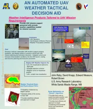
AN AUTOMATED UAV WEATHER TACTICAL DECISION AID . UAV Weather TDA 4-D visualization for mission profile. UAV cockpit View during return leg. Moderate Icing Flight Level 9000 – 11000 ft. Light Turbulence Flight Level 7000 to 11000 ft. Cloud Layer Tops 12000 ft Bases 7000 ft.

E N D
AN AUTOMATED UAV WEATHER TACTICAL DECISION AID UAV Weather TDA 4-D visualization for mission profile. UAV cockpit View during return leg Moderate Icing Flight Level 9000 – 11000 ft Light Turbulence Flight Level 7000 to 11000 ft Cloud Layer Tops 12000 ft Bases 7000 ft • Display UAV Weather Impacts Via: • 2-D, 3-D visualizationstailored to flight path • Stoplight depiction scheme • Weather icons for hazardous weather • UAV cockpit view visualization UAV cockpit view of target area. Departure Point Target Area Obscured Cloud Layer Tops 4000 ft Bases 500 ft Target Area Weather Threshold Rules- and Physics-Based TDA’s: • Probability of detection by target’s sensor • Assesses ability of the enemy to hear UAV • Provides stealthiest altitude and approach to target Weather Intelligence Products Tailored to UAV Mission Requirements Provide UAV mission support personnel with enroute weather capabilities needed for mission success! Customers •UAV Operators • Intel Analysts & Mission Planners •Weather Forecasters & Briefers Goal Develop a tailored, deployable UAV weather support analysis, prediction, and display system to enhance critical DoD UAV mission planning and execution decisions. Integrate current and forecast critical weather conditions into the UAV launch, routing, and recovery planning and execution processes U.S. Army Research Laboratory John Raby, David Knapp, Edward Measure, Robert Brown U.S. Army Research Laboratory White Sands Missile Range, NM • Route Optimization via “Genetic” Algorithms • Provides best route to exploit favorable weather, and avoid hazardous weather • Provides best altitude and approach to target considering environmental factors and operational constraints