Comparative Analysis of Athabasca Vallis Dunes and Siberian Subaqueous Dunes
This study explores the morphological similarities between dune structures in Athabasca Vallis on Mars and subaqueous dunes found in Siberia. Both locations exhibit comparable features indicative of similar formative processes in flat, paleoenvironments. Key observations include dune size, shape, slope asymmetry, and their geological context, suggesting a history of catastrophic aqueous flooding. The analysis employs photoclinometry techniques to assess the topography and slope characteristics of the Athabasca Vallis dunes, revealing insights into recent water activity on Mars.

Comparative Analysis of Athabasca Vallis Dunes and Siberian Subaqueous Dunes
E N D
Presentation Transcript
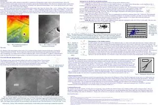
Introduction: The giant circum-Chryse outflow channels on Mars show a combination of morphologies similar to that in terrestrial floodscapes, such as the Channeled Scabland, which argues strongly for their catastrophic aqueous flood formation (Baker, 1982). Transverse subaqueous dunes (“giant current ripples”) were one of the morphologies most diagnostic of flooding in the Channeled Scabland (Baker, 1973), but are missing from the suite of flood morphologies seen in the >2 Ga circum-Chryse channels. One MOC image from a much more recent Martian outflow channel shows dune-like features (Figs. 1 and 2). Athabasca Vallis is the youngest known flood channel on Mars, dated at 2-8 Ma (Burr et al. 2002b), 3 orders of magnitude younger than the circum-Chyrse channels. Located in the Cerberus Plains region, the Athabasca Vallis originates at a fissure and stretches over 300 km to the southwest, where it disappears beneath Cerberus Plains lavas. Determining the amount of water that flowed carved Athabasca Vallis would constrain the amount of very recent surface and subsurface water movement on Mars (Burr et al. 2002b). Analogy between the Siberian and Athabascan dunes: A variety of data argue for similar formative processes for both the Siberian and the Athabascan dunes: --setting: Both are located in flat areas which were sites of paleo-backwaters. As evidence for the Siberian dunes, see the strandlines in Fig. 4, remnants of a paleolake in the Kuray basin; for evidence of ponding in Athabasca, see Burr (submitted). --planviewmorphology: The Siberian and the Athabascan dunes are of a similar scale. The Siberian dunes are a minimum of 15 m long on the southern side of the dune field, increasing to a maximum of 200 m long on in the northwest (Carling, 1996a). They are straight to barchanoid (slightly sinuous and crescent shaped, partly coalesced) dunes with saddle spaced evenly every 60-120 m. The Athabascan dunes average ~50 m long. They also are straight to barchanoid, with saddles spaced at approximately 50-80 m. (See drawing to the right for illustration of terms.) --slopes: The Siberian dunes are up to 16 m high. They are asymmetrical as is normal for subaqueous dunes (Fig. 5, below left); stoss (upstream) slopes are shollower than lee (downstream) slopes, created by avalanching of sediment. For anti-dunes, in contrast, stoss slopes are steeper than lee slopes. The Athabascan dunes are likewise asymmetrical (Fig. 5), having more shallow (typically 4o-14o) slopes in their stoss sides and steeper slopes (typically 8o-20o) on their lee sides. They have a maximum height of 15.3 m. --similar H:L ratio: Fig. 6 shows that the steepest Athabascan features approach a limiting H:L value of 0.12 (Fig. 6, below right). This ratio value is common for terrestrial steep dunes close to equilibrium (Ashley, 1990). Fig.6 -- Measurements of Athabascan features, with the limiting H:L ratio shown by the straight line slope. Fig.5 -- The asymmetry of the Siberian dunes shown on the left (the Kuray dunes are shown as solid circles). A similar asymmetry for the Athabascan features shown on the right (note slightly different scales). The large majority of asymmetry ratios greater than 1, reflecting a slope slope shallower than a lee slope, are consistent with the Athabascan features as dunes (instead of anti-dunes). Photoclinometry of the Athabascan dunes In order to measure the slopes and topography of the Athabascan dunes, we employed the simple photoclinometry technique of Beyer and McEwen (2002), which makes a number of reasonable assumptions about the scene in order to obtain slope estimates for each pixel. The assumptions are that there is no overall tilt to the terrain and that small-scale brightness variations are entirely due to topography (Fig. 7), and not albedo change of materials. The technique utilizes a Lunar-Lambert photometric function to create a lookup table of the ratio of observed brightness over flat brightness for a range of surface slopes. We can then take a ratio of the DN value of each pixel over the average DN of the image, and compare it directly to ratios in the lookup table to obtain a slope measurement for each pixel. The accuracy of the technique is severely limited by the haze in the Martian atmosphere, but reasonable estimates can be made for the haze. This photoclinometry technique measures slopes in the down-sun direction only (bidirectional slopes). However, since the dunes in this study are transverse to the down-sun direction, we are still able to achieve the necessary stoss and lee slope measurements, as well as dunes heights. Fig. 7 -- Variation in albedo with slope. Cartoon illustrates that slopes angled toward the sun appear brighter, and slopes angled away from the sun appear darker. Fig. 1 -- MOLA gridded topography of Athabasca Vallis Fig. 2 -- MOC image E10-01384, showing dunes features This work The Athabasca Vallis dunes appear similar in plan-view to subaqueous dunes found in terrestrial floodscapes, including the Channeled Scabland and Siberia. We investigated the Athabascan dunes' third dimension through photoclinometry, which showed morphology very similar to that of terrestrial subaqueous dunes. Based on this analysis, we applied a sedimentological model, developed for terrestrial subaqueous dunes, to determine the hydraulic conditions that controlled the dunes' formation. Terrestrial (Siberian) subaqueous dunes The subaqueous dunes used as terrestrial analogs in this work are in Kuray, Siberia. They are shown in the aerial photograph below (Fig. 3); their location is shown to the right (Fig. 4). Carling (1996) used these 2-D dunes in Kuray as the basis for developing a paleohydraulic model which relates dune morphology and sedimentology to the paleohydraulics during their formation. Dust infill estimation The topography of the Siberian dunes is subdued by dust (loess) in their troughs; the Athabascan dunes are probably likewise infilled with aeolian dust. We estimated the amount of dust infill for the Athabascan dunes through comparison to terrestrial dune morphology. For a plot of ~425 Earth gravel dunes (not shown in Fig. 8) only 12 points (ie. <3%) (just) exceed Ashley’s limit line for the H:L ratio for equilibrium dunes. These 12 points can be regarded as “oversteep” non-equilibrium dunes. Likewise, the Athabascan dunes (n=72; dark data in Fig. 8) have only 3 points above Ashley’s curve (ie. 4%) similar to Earth. As dunes analogous to those on Earth, the Athabascan dunes’ depth of dust infill must be small; if the dunes had a significant amount of infill, then they would orignally have had an accentuated, and dynamically unlikely, topography (H:L ratio). So how deep is the dust infill in Athabasca? Subtracting a hypothetical dust infill of 0.5 m gives 4 points (5%) above Ashley’s curve; a hypothetical 1 m of infill gives 5 points (7%), which is too high a percentage. Thus we conclude that the depth of dust in the Athabascan dune troughs is not more than 0.5 m and dune height data (height+0.5m) are shown as open symbols on the Fig. 7. Fig. 3 -- ‘K’ marks location of the Kuray, Siberian dunes Fig. 8 -- Athabascan measurements. Sedimentological modeling Carling (1996) developed a paleohydraulic model for late quaternary gravel dunes in the Altai Mountains of Sibera. Paleoflow depths and velocities above the stablized dunes are estimated from a simple force balance for initial motion and the partitioning of the flow resistance between the drag owing to the dune form and the grain resistance. (The model contains an explicit formulation of gravity, so can be applied directly to Martian conditions.) Topographic evidence for the lateral extent of the channel is taken as indicating the lateral extent of the flood. This, in conjunction with flow depth and velocity derived from the modeling, provided estimates of the instantaneous discharge. Modeling indicates that the dunes were initially formed when the flood was on the order of 110,000m3/s, experienced strong growth at 1,380,000 m3/s, and had a maximum potential development before wash-out which would occur around 2,100,000 m3/s. Conclusions/future work We conclude, based on the similarity of setting, plan view morphology, slopes, and H:L ratio, that the features seen in Athabasca Vallis could be subaqueous dunes. However although we cannot completely exclude an aeolian origin and future work will consider this issue, our initial modeling shows them to likely have been formed by aquoes flood with a peak discharge on the order of 2,100,000 m3/s. Future work will also focus on using these calculated values to reconstruct the hydrograph of the Athabasca Vallis flood that formed the dunes. REFERENCES Ashley, G.M. (1990) Classification of large-scale subaqueous bedforms: a new look at an old problem. J. Sedimentary Petrology, 60(1) 160-172. Baker, V.R.(1982) The Channel of Mars. University of Texas. Beyer, R.A. and A.S. McEwen (2002) Photoclinometry Measurements of Meter-Scale Slopes in Support of the 2003 Mars Exploration Rovers, AGU Fall meeting, abstract P22A-0393, Tuesday Dec. 10, 1330, Hall D. Burr, D. M., McEwen, A. S., & Sakimoto, S. E. H. (2002a) Recent aqueous floods from the Cerberus Fossae, Mars. Geophys. Res. Lett., 29(1), 10.1029/2001GL013345. Burr, D.M., Grier, J. A., McEwen, A. S. & Keszthelyi, L.P. (2002b) Repeated Aqueous Flooding from the Cerberus Fossae: Evidence for very recently extant, deep groundwater on Mars. Icarus 159(1), 53-73. Burr, D.M., Hydraulic modeling of Athabasca Vallis, Mars, submitted to Hydrological Sciences Journal. Carling, P.A. (1996a) Morphology, sedimentology and palaeohydraulic significance of large gravel dunes, Altai Mountains, Siberia. Sedimentology, 43, 647-664. Carling, P.A. (1996b) A preliminary palaeohydraulic model applied to late Quaternary gravel dunes: Altai Mountains, Siberia. InGlobal Continental Changes: the Context of Palaeohydrology, (J. Branson, A.G. Brown and K.J. Gregory, eds.) Geological Society Special Publication No. 115, pp. 165-179. Fig. 4 --Aerial photograph showing a portion of the Kuray, Siberia, dunes. The Kuray dunes are low-amplitude (height<16m; length <200m), gravel (max grain size <0.2-0.5m), transverse ridges which extend patchily over a 24-km tract. This photo shows the easterly portion of that tract, which consists of a former lake bed (hence the strandlines in the right of the image) where sediment has accumulated in well-defined dunes. Paleoflow direction is from left to right. Using these dunes, Carling (1996) developed a paleohydraulic model relating dune morphology to paleoflow hydraulics.