Download
1 / 36
390 likes | 703 Vues
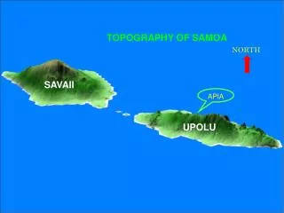
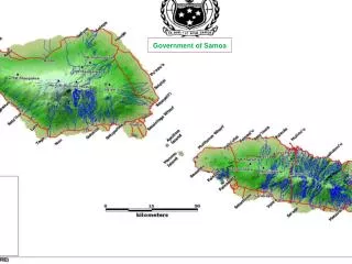
Government of Samoa. Land Tenure in Samoa Samoa became Independence in 1962, having been administered by Germany, and then New Zealand until 1961. It has a population of 181,000 (2006 Census) and a land area of 2,831 square kilometers .(2010-est-200,000)

E N D
Land Tenure in Samoa • Samoa became Independence in 1962, having been administered by Germany, and then New Zealand until 1961. • It has a population of 181,000 (2006 Census) and a land area of 2,831 square kilometers.(2010-est-200,000) • All cadastral and registration services are provided by the MNRE.
Types of Lands • 80%Customary Land, is held under customary ownership, this land is protected under the constitution. • 12%of Public or Government Land. • 8%of Freehold Land.
CURRENT CADASTRAL ARRANGEMENT *Cadastral Survey were undertaken under the survey Ordinance 1961, and the New Legislation for cadastral surveys is currently passed by the Parliament. * Any change in boundaries for freehold, Government land or for registration of lease over customary land, requires a cadastral survey signed by the registered or licensed surveyor .
*A survey plan is lodged with the (MNRE) ,at the Quality Assurance Section of the Technical Division to check and refer to approve by the Chief Executive Officer, if the survey meet all the requirements including the standards described under the survey Regulations. • CURRENT REGISTRATION ARRNGEMENT • Samoa moved to a system of title registration of the Land Title Registration Act 2008, officially implemented on the 2nd March 2009. • This change was accompanied by the introduction of standardized forms. • The implementation of a computerized system and the recognition of the computerized based records, in particular the “Computer Folio”.
1)REGISTRATION PROCESS & DCDB. • 2) EXPERIENCES-NEW REGISTRATION FORMS. • 3)Future Plans • 4) Other Future Land Administration
1) LAND REGISTRATION • MAINACTIVITIES: • REGISTRATION OF LAND DEALINGS/PLANS • -Transfers, Mortgages, Transmission, Caveats etc • - Approved Survey Plans) • PROVIDING LAND INFORMATION • -Search Registration & Cadastral Records • - Digital Archive, LRS Database, Old Land Records ) • Create “Computer Folio Certificates” • KEEPING & SCANNING OF LAND RECORDs. • -Court Grants, Land Claims, Old land records (etc) • -Archive Paper Documents
Registration Process Steps Designed by Neil Pullar
RELEASE RECEIVE LODGEMENT DEALINGS PAY FEES CLIENT SOLICITOR BUY FORMS DESPATCH FLOW DESPATCH “COMPUTER” CERTIFICATE CHECK LRS DATABASE & SURVEY PLANS LAND REGISTRATION PROCESS FLOW REQUISITIONS TO CLIENTS FLOW SCAN & ARCHIVE PAPER DOCUMENTS REGISTER DEALINGS IF CORRECT IF NOT REQUISITION. REGISTER APPROVED PLANS CREATE COMPUTER FOLIO CERTIFICATE FLOW FLOW
REGISTRATION STAFF RECEIVE & DESPATCH PROVIDE INFORMATION NUMBERING PLANS/DEALINGS REGISTRATION OF DEALINGS SCAN UPDATE LRS DATABASE ARCHIVE PAPER
QUALITY ASSURANCE SECTION Record Map Survey plan DCDB DATABASE Residue plan
“DIGITAL CADASTRAL DATABASE RECORD MAP SCANNED IMAGES OF SURVEY & TITLE SURVEY PLANS DIGITAL IMAGE WITH ATTRIBUTE CAPTURE DIGITAL CADASTRAL DATABASE DIGITAL IMAGE
2) EXPERIENCES & NEW REGISTRATION FORMS IMPORTANT CHANGES Capability for members of the Public to act for themselves in land transaction. Ready to access to title information through the Computer Certificate. “While you wait” registration available in urgent cases. Replacement of Complex Deed forms with simple, easy to read single page dealing. Standards & Memorandum of Mortgages from various Banks, lodged once in the Ministry.
DEALING FORMS Lease Variation of Mortgage Termination of Lease Transmission Transfer Mortgage REMOVAL OF CAVEAT Form 25 Caveat
EXAMPLES OF COMPLEX DEEDS DOCUMENTS LEASE- 10 pages MORTGAGE 20 PAGES CONVEYANCE/TRNSAFER 2-10PAGES DISCHARGE/MORTGAGE 2-4PAGES
Future Plans • APPROVED FORMS AVAILABLE ELECTRONICALLY • ELECTRONIC LODGMENT OF DOCUMENTS • APPROVED The Stamp Duty to relocate from the Ministry of Finance to the MNRE. • OSCAR- OPEN SOURCE CADASTRE AND REGISTRATION • MNRE GOAL- reduce the cost of software licenses • Build up MNRE expertise software develop & • soft ware support, mainly reduce dependency on overseas experts.
OTHER FUTURE LAND ADMINISTRATION • MNRE wide limited, read only access to • Samoa Viewer (GIS viewer) • Digital Lodgment for Registration Dealings and Cadastral Survey. • Cadastral & Registration Digital Archive. • MNRE wide limited, read only access to Land Registration System. • Land Registration System (software) support including enhancements for the Unit (Strata) Title Legislation, valuation and requisition notices (etc).
“THANK YOU” “FAAFETAI LAVA” “ FROM SAMOA”