Download
1 / 22
230 likes | 384 Vues
McIDAS -V, visualization and data analysis for Suomi National Polar-orbiting Partnership. William Straka III 1 Tommy Jasmin 1 , Dan Lindsey 2 , Steve Miller 3 , Thomas Rink 1 , Don Hillger 2

E N D
McIDAS-V, visualization and data analysis for Suomi National Polar-orbiting Partnership William Straka III1 Tommy Jasmin1, Dan Lindsey2, Steve Miller3, Thomas Rink1, Don Hillger2 1Cooperative Institute for Meteorological Satellite Studies, Space Science and Engineering Center, University of Wisconsin-Madison 2NOAA, RAMMB 3Cooperative Institute for Research in the Atmosphere, Colorado State University 1
Outline • Overview of McIDAS-V • Overview of Suomi NPP • Examples • Conclusions 2013 EUMETSAT Meteorological Satellite Conference 16-20 September 2013, Vienna, Austria 2
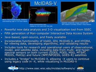
What is McIDAS-V McIDAS-X VisAD + IDV + HYDRA = McIDAS-V • Integration of Geophysical Data • Remote and Local Data Access • Powerful Analysis Tools • 3D Visualization • Ease of Re-projection
Key Aspects of McIDAS-V • Built on top an extensible framework for adapting new sources of data (format and type, local or remote), user interface components and for creating novel displays and analysis techniques • Developed in the Java programming language – object oriented, write once run anywhere, very portable • Persistence mechanism (bundles) for saving and sharing interesting displays/analysis with other McIDAS-V users • Python based user defined computation • Open source, freely available, community driven software • Is able to easily read in and manipulate NPP with out any special readers 2013 EUMETSAT Meteorological Satellite Conference 16-20 September 2013, Vienna, Austria
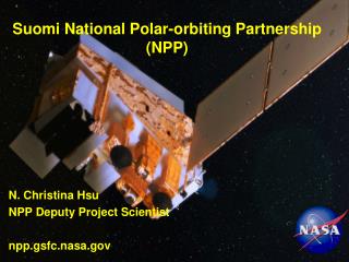
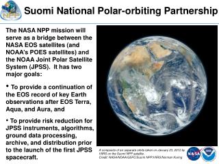
Suomi NPP • S-NPP observes the Earth’s surface twice every 24-hour day, once in daylight and once at night. • It has 5 instruments which retrieve data regarding the atmosphere, land and ocean • VIIRS • CERES • CrIS • ATMS • OMPS 2013 EUMETSAT Meteorological Satellite Conference 16-20 September 2013, Vienna, Austria 5
Advanced Technology Microwave Sounder(ATMS) • 22 microwave channels, combining all the channels of the preceding AMSU-A1, AMSU-A2, and AMSU-B sensors into a single package • Provides sounding observations needed to retrieve profiles of atmospheric temperature and moisture for forecasting models and continuity for climate monitoring purposes. 6
Cross-track Infrared Sounder(CrIS) • 1,305 infrared spectral channels • Designed to provide high vertical resolution information on the atmosphere's structure of temperature and water vapor. 7
Visible Infrared Imaging Radiometer Suite (VIIRS) • Has 22 channels at three different resolutions • 16 Moderate Band (M-Band) channels (~750 m at nadir) • 5 high resolution (I-Band) channels (~375 m at nadir) • Day Night Band (~750 m at nadir) • M and I band data encompass data from 412 nm to 12 μm • Used to produce Level 2 products 2013 EUMETSAT Meteorological Satellite Conference 16-20 September 2013, Vienna, Austria 8
Day Night Band • The DNB measures visible radiances from both the Earth and atmosphere • Wavelength of 0.7 mm, 742m x 742m pixel size • Receives visible data from via reflection and emission sources (natural and anthropogenic ) • Stray light fix implemented August 21, 2013 Figure 1 from Lee et al (2005) 9 2013 EUMETSAT Meteorological Satellite Conference 16-20 September 2013, Vienna, Austria
Tongariro (New Zealand)August 6, 2012 – 1252Z Ash 10 NASA Image of the Day http://earthobservatory.nasa.gov/NaturalHazards/view.php?id=78791
VIIRS (11, 3.9mm and DNB)0733Z, July 15, 2012 Fires Winnipeg Aurora Chicago 2013 EUMETSAT Meteorological Satellite Conference 16-20 September 2013, Vienna, Austria 11
VIIRS Channel DifferencingDNB Stray light example 2013 EUMETSAT Meteorological Satellite Conference 16-20 September 2013, Vienna, Austria 12
VIIRS SDRAncillary data 2013 EUMETSAT Meteorological Satellite Conference 16-20 September 2013, Vienna, Austria 13
Visible Infrared Imaging Radiometer Suite (VIIRS) EDR • There are a series of 20 Environmental Data Records (EDRs) produced from VIIRS • McIDAS-V has been able to sucessfully ingest all but the Imagery EDRs • Imagery EDRs are expected to work by end of 2013 • McIDAS-V can unpack and display bit level data. • Ex. Displaying cloud mask test results 14
VIIRS DNB, Surface temperature2236Z, 09/29/2012 Kampala Lake Albert Fog Kigali Mwanza 15 Lake Victoria
Product EDR Variable selection 2013 EUMETSAT Meteorological Satellite Conference 16-20 September 2013, Vienna, Austria
Product EDR Data Probe 2013 EUMETSAT Meteorological Satellite Conference 16-20 September 2013, Vienna, Austria
Imagery EDRs 2013 EUMETSAT Meteorological Satellite Conference 16-20 September 2013, Vienna, Austria
Conclusions • McIDAS-V is a free, open source tool which can be used to evaluate data from various instruments on Suomi NPP, assuming the data is in the IDPS/CLASS NPP format • Allows for intercomparison with other sensors and satellites as well as exploration of geolocation and bit flags • It can be used to easily make images and animations for presentations • Improvements continue including adding VIIRS intermediate products 19
QUESTIONS? Austin San Antonio 20
Allegheny River fog event Toronto Syracuse Rochester Finger Lakes Buffalo Fog Clouds 2013 EUMETSAT Meteorological Satellite Conference 16-20 September 2013, Vienna, Austria 21
VIIRS DNB / 11um2308Z, 5/1/2012 Lightning “streaks” Kampala Nairobi Mombasa 2013 EUMETSAT Meteorological Satellite Conference 16-20 September 2013, Vienna, Austria 22 Lake Victoria