Download
1 / 11
110 likes | 250 Vues
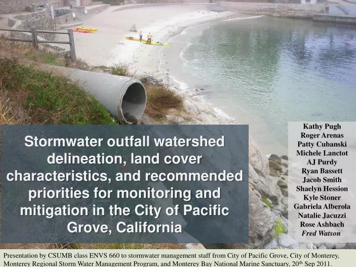
Stormwater outfall watershed delineation , land cover characteristics, and recommended priorities for monitoring and mitigation in the City of Pacific Grove, California. Kathy Pugh Roger Arenas Patty Cubanski Michele Lanctot AJ Purdy Ryan Bassett Jacob Smith Shaelyn Hession Kyle Stoner

E N D
Stormwater outfall watershed delineation, land cover characteristics, and recommended priorities for monitoring and mitigation in the City of Pacific Grove, California Kathy Pugh Roger Arenas Patty Cubanski Michele Lanctot AJ Purdy Ryan Bassett Jacob Smith ShaelynHession Kyle Stoner Gabriela Alberola Natalie Jacuzzi Rose Ashbach Fred Watson Presentation by CSUMB class ENVS 660 to stormwater management staff from City of Pacific Grove, City of Monterey, Monterey Regional Storm Water Management Program, and Monterey Bay National Marine Sanctuary, 20th Sep 2011.
Field Methods • Located outfalls 10” diameter and greater • Coordinates & measurements recorded • Photographed • Field validated GIS delineated watersheds
DelineationMethods • Imported storm drain mains data and Digital Elevation Model • Reclassified storm drain raster to be binary • Subtracted reclassified storm drain raster from the DEM to create “burned” DEM. • Imported storm drain outfall location data • Hydrology Tools within Spatial Analyst • Fill analysis • Directional analysis • Accumulation analysis • Edited outfalls • Watershed analysis
Land Use Impervious Cover • Land use data source: Monterey County Tax Assessor’s Office and City of Pacific Grove. • Impervious cover data source: USGS, NLCD 2006
Potential Mitigation Treatment Wetlands Stormwater outflow Treatment Wetland Detention Pond Stormwater inflow Watershed #8, Greenwood Park Basic Schematic of Wetland System
Potential Mitigation Bioretention Image courtesy of Ole Christensen
Potential Mitigation Direct Rainfall Interception Green concrete alternatives Surface Runoff Interception Aggregate Base 1 (1-2”) GCA 4-8” Aggregate Base 2 (+6”) Natural Substrate
Next steps • Prioritize delineated watersheds according to mitigation needs • Collect data necessary for hydrologic modeling • Precipitation • local, high-resolution • Outfall discharge • Key outfalls • Soil Characteristics • Field verification • Continued water quality monitoring • Build and calibrate watershed model • Greenwood Park given priority • Assess mitigation measures feasibility using model simulations • Restructure and reassess mitigation designs if needed • Implement mitigation measures • Continue monitoring