The Marine Environment
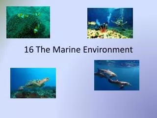
The Marine Environment. Chapter 16. 16.1 Shoreline Features . Shorelines are shaped by the action of waves, tides and currents As waves erode coastlines, they create impressive rock formations Sometimes, waves drop/deposit loose sediments and build wide, sandy beaches

The Marine Environment
E N D
Presentation Transcript
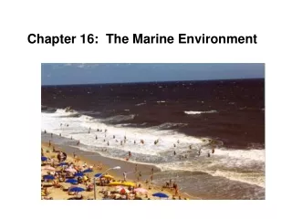
The Marine Environment Chapter 16
16.1 Shoreline Features Shorelines are shaped by the action of waves, tides and currents As waves erode coastlines, they create impressive rock formations Sometimes, waves drop/deposit loose sediments and build wide, sandy beaches Waves move faster in deeper waters than they do in shallow waters Wave refractions – difference in wave speed causing straight wave crests to bend when the crest moves into shallow water
Erosional Landforms • Rocky headlands – points of land sticking out into the ocean • Caused by the destructive action of breakers • Can be modified by wave erosion • Sea stacks / sea arches form from wave refraction at the rocky headland
Beaches • Sloping band of sand, pebbles, gravel, or mud at the edge of the sea • Composed of loose sediments deposited and moved about by waves along the shoreline
Beach Composition • Depends on source of material • Hawaii – black sand/tiny grains of minerals from volcanic rocks • Southern Florida / Bahamas – white / pink sand from fragments of local corals and seashells • Near mouths of large rivers – sandy sediments washed in by river water, small grains of quartz and feldspar • Size of sediment particles depends on energy of waves striking the coast
Estuaries • The area where the lower end of a freshwater river or stream enters the ocean • Water is blackish in color • Water is a mixture of freshwater and saltwater • Nurseries to young of many different species • Examples include the Chesapeake Bay and the Pamlico Sound
Longshore Currents • Longshore bar – submerged sandbar located in the surf zone • Longshore current – current that flows parallel to the shore • Moves large amounts of sediments • Forms when incoming breakers spill over a Longshore bar
Longshore Currents (cont.) Movement of Sediments • Longshore currents move large amounts of sediments along the shore • Fine-grained materials are suspended in turbulent, moving water • Large materials are pushed along the bottom of the current • Some sediments are pushed back and forth on the beach (incoming/outgoing waves) • Longshore transport is generally to the south • Wave action produces rip currents, which flows out to the sea through gaps in the Longshore bar • Return the water spilled into the Longshore trough to the open ocean • Currents can reach speeds of several km/hr • One should never swim against rip currents, but should swim parallel to the shore to get out of the current Rip Currents
Depositional Features of Seashores Most seashores are in a constant state of change Sediments are eroded by large storm waves and are deposited where waves slow down
Sediments deposited build coastal landforms Tombolo • Ridge of sand that forms between mainland and an island • Connects the island to the mainland • When this is present, it makes the island the “tip” of a peninsula • Shallow, protected body of water behind barrier islands • Essentially coastal lakes • Connected to sea by shallow, restricted outlets Lagoon
Depositional Features of the Shoreline Spit • Narrow bank of sand that projects into the water from a bend in the coastline • Forms where a shoreline changes direction • Protected from wave action • When growing spit crosses bay, baymouth bar forms • Long ridges of sand or other sediments • Deposited or shaped by longshore currents that are separated from mainlands • Can be several km wide / tens of km long • Unstable and temporary Barrier Islands
Protective Structures • Structures are built to prevent beach erosion and destruction of oceanfront properties • Interfere with natural shoreline processes
Examples and Negative Effects of Protective Structures Seawalls • Built along shore to protect oceanfront properties • Reflect waves back to the beach • Protect oceanfront properties • Worsens beach erosion • Wall-like structures build into the water perpendicular to the shoreline to trap beach sand • Interrupts natural longshore transport • Deprives beaches of sand down the coast Groins
Examples and Negative Effects of Protective Structures Jetties • Walls of concrete built to protect a harbor entrance from drifting sand • Jetties trap sand upshore • Prevents sand from reaching beaches downshore • Built in the water parallel to straight shorelines to provide anchorages for small boats • Affects longshore currents causing them to no longer be able to move its load of sediment • Causes currents to drop and eventually build up to fill anchorage locations Breakwaters
Changes in Sea Level Earth’s sea level rises and falls over time with changing of the Earth • Ice Age • Causes sea level to lower as the water freezes into ice caps • End of Ice Age • Causes sea level to rise due to the ice melting • Rise of Earth’s Surface Temperature • Causes seawater to warm up and expand • Adds total volume to the sea • Tectonic Movement (uplifting and sinking) • If a coastline sinks, rise in sea level along that coast • If a coastline rises, sea level along that coast drops • Emergent Coast – region that was formerly underwater • Tends to be relatively straight • Characterized by sandy beach ridges located far inland and elevated marine terraces
16.2 The Seafloor Until recently, most people had little knowledge of the features of the ocean floor. The topography of the seafloor is surprisingly rough and irregular, with numerous high mountains and deep depressions.
Oceanic and Continental Crust • As learned previously, the Earth has two types of crust: • Continental Crust – avg. thickness of 40km • Oceanic Crust – avg. thickness of 6-7km • Crustal elevation depends on crustal thickness, which is why thicker crust occurs on land and thinner crust occurs deep within ocean basins • Part of the continental section is actually below sea level and the ocean covers parts of the continents. These submerged portions are called continental margins and include the continental shelf, the continental slope and the continental rise.
Continental Shelves The shallowest part of the continental margin, extending seaward from shore The average width is 60km, although width varies greatly
Continental Slopes • Sloping regions where the seafloor drops away quickly, beyond the continental shelves • True edge of the continent • Often “cut” by submarine canyons, which are formed from turbidity currents
Continental Rise Gently sloping accumulation of sediments dropped off by turbidity currents, forming at the base of the continental slope. This may be several km thick.
Ocean Basins • Deeper parts of the seafloor that lie above thin, basaltic, oceanic crust • Beyond the continental margin • Represents about 60% of the Earth’s surface
Topography of Ocean Basins Abyssal Plains • Smooth parts of the ocean floor • 5 or 6 km below sea level • Covered with hundreds of meters of muddy sediment • Probably flattest surfaces on Earth • Deepest part of the ocean basins • Narrow, elongated depressions in the seafloor • Many lie next to chains of volcanic islands • Most located around margins of Pacific Ocean Deep Sea Trenches
Topography of Ocean Basins Mid-Ocean Ridges • Most prominent features of ocean basin • Run through all ocean basins, total length of over 65,000km • Average height of 1500km, but varies • Sites of frequent volcanic eruptions and earthquake activity • Hole in the seafloor through which fluid heated by magma erupts • Most located along bottom of rifts in mid-ocean ridges • “Black Smoker” or “White Smoker” classification, depending on what is ejected from the vent Hydrothermal Vents
Seafloor Volcanoes • Mountains are found all throughout the seafloor • Believed to be extinct volcanoes, rather than mountain ranges • Two types: • Seamounts • Submerged basaltic volcanoes more than 1km high • Many stretched across the Pacific Ocean Basin • Guyots • Also called “tablemounts” • Large, extinct basaltic volcanoes with a flat, submerged top
Marine Sediments • Come from a variety of sources, most from continents • Includes mud and sand washed into oceans by rivers, as well as volcanic ash blown over the ocean by winds
Types of Marine Sediments Manganese Nodules • Major source of deep-sea sediment (shells and hard parts of marine animals) • Typically accumulate at a rate of a few mm per thousand years • Most are small, consisting of either calcium carbonate or silica • Consist of oxides of manganese, iron, copper, and other valuable metals • Growth rates are incredibly slow • Measured in mm per million years Ooze