Download
1 / 20
200 likes | 281 Vues
Learn about the Global Map project, its history, importance, and the need for improving global datasets for better environmental decision-making. Understand the principles, specifications, and upcoming initiatives for a comprehensive global mapping system that benefits mankind. Explore key datasets, past meetings, and the recommendation letter from the United Nations supporting this vital endeavor.

E N D
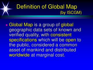
Definition of Global Map (by ISCGM) • Global Map is a group of global geographic data sets of known and verified quality, with consistent specifications which will be open to the public, considered a common asset of mankind and distributed worldwide at marginal cost.
Current Global Data Sets for Global Environment • DEM: GTOPO30 (Global 30 arc second elevation data set) (EROS Data Center/USGS) • Cartography : DCW (Digital Chart of the World) > VMAP(Vector Map) Level 0 (US National Imagery and Mapping Agency) • Land use/cover : GLCC (Global Land Cover Characterization) (EROS Data Center/USGSand IGBP DIS Land Cover WG)
Issues of Existing Global Data Sets • Uncertain quality • Some data sets do not have clear quality information. • Global inhomogeneity • Data quality is not globally homogenous. • Uncertain schedule for data revision • No plan of updating data. Global Mapping Initiative through cooperation between national, regional and international organizations
Why do existing global data sets need to be improved? Shaded Relief Map of Nepal (source GTOPO30)
Why do existing global data sets need to be improved? River and Road Network in VMAP Level 0
Principles of the Global Map • Covers the whole land area. • Spatial resolution: 1 km, nearly equivalent to map at the scale of 1:1,000,000 • Open and worldwide distribution at marginal cost. • Revised every five years.
History of Global Mapping Project • 1992 Agenda 21 (Rio de Janeiro) • Article 40: Information for Decision Making • 1992 Initial Proposal by Ministry of Construction • 1994 1st International Workshop for Global Mapping • 1996 2nd International Workshop for Global Mapping • Establishment of International Steering Committee for Global Mapping
History of Global Mapping Project • 1996 UN Interregional Seminar on Global Mapping for Implementation of Multinational Environmental Agreements (Santa Barbara, USA) • 1997 UN General Assembly for Sustainable Development • 1997 Global Mapping Forum ’97 in Gifu (Japan) • 1998 Global Mapping Forum ‘98 in Sioux-Falls (USA) • 1998 UN Letter for Participation in GM Project • 2000 Global Mapping Forum 2000 in Hiroshima
Programme for the further implementation of AGENDA21 “A supportive environment needs to be established ... to facilitate public access to information on global environmental issues ... using ... such tools as geographic information systems and video transmission technology, including global mapping. ...” (Paragraph 112 : Adopted document of the UN General Assembly, June 1997)
International Steering Committee for Global Mapping • member : 18 persons from 15 countries • advisor : 7 persons • Member countries and organization • Australia, Bangladesh, Canada, China, France, Iran, Japan, Kenya, Korea, Malaysia, New Zealand, Niger, South Africa, United Kingdom, USA, MEGRIN, SCAR-GGI • Advisory organization • UN, UNEP, UNU, ICA, NGS • Secretariat :Geographical Survey Institute of Japan
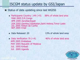
ISCGM Meetings • Establishment of ISCGM and First meeting at Tsukuba in Feb. 1996 • Second meeting at Santa Barbara in Nov.1996 • Third meeting at Gifu in Nov. 1997 • Fourth meeting at Sioux-Falls in Jun. 1998 • Fifth meeting at Canberra in Nov. 1998 • Sixth meeting at Cambridge in Jul. 1999 • Seventh ISCGM Meeting on March 16, 2000 in Cape Town, South Africa
Basic Specifications of Global Map • Designated by ISCGM in 1998. • Data contents: • Vector Layers • drainage system (rivers and lakes), transportation (roads, railways, airport etc.), administrative boundaries, population centers • Raster Layers • elevation, vegetation, land cover, land use
Existing Datasets to be Used • Global 30 Arc Second Elevation Data Set • Elevation (DEM) • Global Land Cover Characteristics Database • Land Cover • Land Use • Vegetation • VMAP Level 0 • Drainage System (rivers, streams, lakes) • Transportation (roads, railways, airports) • Political Boundaries (including coastlines) • Populated Places
Recommendation Letter of Global Mapping by UN • UN sent the letter of ISCGM inviting Global Mapping Project and the letter of UN recommending the project to the head of National Mapping Organizations in November 1998.
SCAR/WG-GGI participates inGlobal Mapping Project • SCAR WG-GGI participated in the Global Mapping Project on March 9, 1999. • Mr. Drew Clarke, Chairman of SCAR WG-GGI has been invited as one of ISCGM members since 5th Meeting in 1998.
Global Map Data for Antarctic • British Antarctic Survey (BAS) is simplifying the revised Antarctic Digital Database (ADD) to a 1:1,000,000 scale version. • The data are under being checked by ISCGM Secretariat. • It will be returned to BAS, and revised until 2001.
Timetable of Global Mapping • First phase - 2000 • Release Global Map ver. 1.0 prepared from existing global scale geographic data • Second phase 2001 - • Regular update (every five years) and Promotion of data use
Global Mapping Forum 2000 Hiroshima • Global Mapping Forum 2000 will be held in Hiroshima from 28 to 30 Nov. 2000 • Aims : • Commemorate completion of Global Map Version 1.0 • Declare start of distribution of Global Mapping Data • Urge usage by introducing examples of application • Discuss plan for promotion of Phase 2 of the Project • Distributing GM sample data to Researchers
Future Cooperation ISCGM / SCAR WG-GGI • Need to revise and update the data periodically. • Secretariat of ISCGM and SCAR WG-GGI will continue to communicate. • If necessary, GSI will make effort to contribute such activities as a member of WG-GGI.