Chapter 4 Flood Plains Management
430 likes | 730 Vues
Integrated Urban Flood Management. Chapter 4 Flood Plains Management. Flood Plains Management . Goals Describe the assessment and management of the natural floods in the urban flood plains of median and larger basins. Objective

Chapter 4 Flood Plains Management
E N D
Presentation Transcript
Integrated Urban Flood Management Chapter 4 Flood Plains Management
Flood Plains Management Goals Describe the assessment and management of the natural floods in the urban flood plains of median and larger basins. Objective This chapter describes the contents of flood plains type of floods. The important contents presented are: main flood assessment concepts; the non-structural and structural measures; and Economic aspects of flood management.
Flood Plains • Inundation in the floodplains occurs when the river overflow its banks as a natural process. It occurs with a frequency of 1.5 to 2 years return period
Impacts • Loss of lives: usually due levels and velocity of the flow near to the rivers or hill slide which destroy houses; • Direct economics: losses in houses, commercial and industrial buildings due to the affecting water depth and velocity, agriculture goods; • Indirect economic losses: loss of: working hours, selling goods, industrial production and agriculture. • The main impacts on the population occur due to lack of: knowledge regarding the occurrence of flood levels, and planning for space occupancy according to the risks of flood events
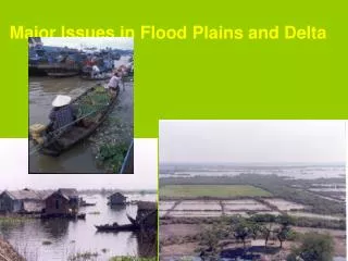
Scenarios • Planning the occupation of the floodplains is not new. • Aquenaton in 1340 aC selected a new capital, Amarna, which was planed taking into account the floods. “From East to West two dry floodplains areas were nothing was constructed because of the floods fears, sub-divided the city in three parts: downtown, residential neighbourhoods from North to South” (Brier, 1998). • the population occupies the flood plain during a sequence of years with low maximum annual levels, since the flat areas are favourable to settlement. • When years with higher floods return, damages are significant and the population demands that governments take action to build control structures such as dams and others.
Examples • For a long time, floods levels in Iguázu river at Uniao da Vitória Brazil, remained below the 5-year return period. From 1982 to 1993 the flood damages was over 180 millions dollars for a community of about 75,000 inhabitants. • It generated a conflict since in 1980 was constructed a dam downstream and population blamed the dam operation
União da Vitória e Porto União 1983 flood
Pantanal • Low levels between1960 to 1973; increased after that. • Increase of 17.000 km2 flood area to 50.000 km2 • Na area which floodes 20% in the 60’s, now it floods 85% • Large social and economic impact in the population of the area
Flood assessment • Flow forecasting is related to the flow evaluation in a lead time. The river flow forecast can be estimated in short-term, few hours or some days of lead time and long-term, up to nine months. • Prediction is the probability of the flow occurrence based in the historical flow records. It does define when it is going to occur, only the chances. It is used for scenarios evaluation of flood risk.
Flow forecast • Forecast based on the rainfall: base on the rainfall it calculates the flow; • Forecast based on the upstream level or flow: . • Combination of previous scenarios
Flood control measures • Structural measures are related to the change of the basin and/or the river such as dams, dikes, channel conveyance, basin forestation, among others. • Non-structural measures are based in measures related to flood mitigation such as: insurance, flood zoning, and flood forecasting. Structural solutions have higher costs and it is feasible only when damages costs are greater than their development or due to intangible social aspects.
Structural measures • The structural measures are classified in extensive and intensive. • The extensive measures are developed over the basin such a reforestation, soil conservation, among others. These measures usually can be developed only over small basins because of the cost of intervention. • The intensive measures are developed in the river such as: reservoirs, dikes, river section changes and slopes, river deviation.
Reservoir • The main use of a reservoir in flood control is to store water and decrease the peak flow to downstream reaches • The normal scenario is the reservoir to hold volume only after a maximum discharge Qmx is reached downstream, since many floods occurs after a sequence of rainy days filling the reservoir and when come the peak the reservoir is already flooded.
Dikes • Dikes are lateral walls of earth or concrete, with some slope or vertical, constructed at some distance of the banks. • The dike restricts the flow inside of the walls and the river bed increasing the flow level and the velocity. • This situation can increase the bed erosion and reduction of time transport of the flood to downstream reaches
Lateral flow • For larger inflow river the dikes could follow the topography entering the tributary. • In small rivers the hydrographs of should be controlled. When the river has a level smaller than the lateral flow it can flow by gravity, but when the river has a level greater a gate type such as a “stop-log” is used to do not allow the river enters the lateral area. • During that period the inflow from the lateral basin is pumped to the river. Depending of the volume a lateral small reservoir is designed in order to decrease the pump flow capacity
Changing de river Cutting a meander
Non-Structural measures • Flood zoning is the planning of the soil occupation and regulation in order to decrease future flood impact. Since part of the population still will be living in risk areas; • the flood forecasting is developed in order to alert this population and decrease their damages to flood; • Insurance is preventive procedure used in order to recover the cost damage of properties in flood risk areas. It is feasible for owners and properties with important value. In addition, not all country the insurance is available for ordinary people; • Flood proofing is an individual measure developed by the owner in order to protect its physical assets.
Flood zoning • Flood zoning is the definition used for the land use space planning in order to regulate the occupation of flood risks areas with a main goal of minimizing the flood impacts. • Flooding zoning allow the rational occupation of flood plain risk areas. • The regulation of the space is based on flood mapping where the risk are estimated based on the historical information and specific conditions of the land use.
Flood probability map • Prepare the flood flow frequency based on the yearly peak discharges existing in the gage section; • Select a risk (return period) and determine the flow in the flood flow frequency for the gage section. Using the rating curve of the gage (which is the flow x level relationship for the gage section); • Determine the river level with this return period. This level has to be converted at the same reference level of the city topography • Using this level it is possible to find in this section which is the width (both side of the river) of this flood flow. • The same width can be found in upstream and downstream section of the gage using the river slope . It also can be calculated by mathematical model when there is not that type of information from similar floods; • The procedures from b to d can be repeated for each flood risk selected.
Rating curve Flood frequency
Flood zone maps • Floodway – which the area which the river uses in order to develop the flow and the occupation of this area could increase the level upstream. • Area with restrictions: it is allowed the occupation with some conditions; • Low risk areas: where still there are some restrictions but it is more a warning to the real state owners.
Technical criteria • Flood limits: usually the flood limits is determined by the 100 flood risk or an important well known flood with risk above 100 years. It does not say the flood would not occur but its chance is 1% in a specific year. • Floodway - In the flow through the city the river slope can change due to obstruction to the flow by land fills, bridges, other constrictions and hydraulic works.
Floodway zone • In this zone should not have constructions which could decreases the flow river capacity; • For existing works and constructions there is a need to evaluate its effects and develop a plan to change its conditions. For population and construction it would be sound to develop a plan for transference of that population for a safe area together with the demolitions of the constructions. It requires an assessment since the cost of transference can not be greater than the mean flood impact cost, taking into account only the economical component; • In works such as bridge, roads land fills and other infra-structures the simulation of the hydraulics river levels for the scenarios with and without the obstruction will allow the correct assessment in the investments; • The use of the area can be for recreation such as parks, for agriculture since it is close to the market, mainly for vegetables; infra-structures which does not have obstruction; parking lots among others.
Area with Restrictions • this area is allowed the occupation in the flood space but with some restrictions in order to mitigate the potential risk to floods. • the flow velocity should be small and the impact is much more related to submersion. • Parks and recreation activities such as sports areas. The maintenance of the these areas such be small after each flood; • Agriculture area such as for vegetables, since it is near the consumer; • Residential areas for at least two stores building where the superior stores are in safe level, allowing its use during floods events; • Industrial and commercial area of loading, parking lots, storage of equipments which can be easily removed or are not subject to flood damage. It can not be used for storage of toxic contents; • Basic services: transmission lines, roads, bridges (without increasing the upstream floods).
Low risk areas • this area has low probability to be flooded, but it can happen and the population needs to be informed about the risk. • In this scenario is likely the flow velocity and flood levels are small. • Usually this area is not regulated, but if the risk is small and the velocity is high is important that the regulation should develop prevention for constructions in relation to damage risks.
Regulation of the flood areas • Regulation of these areas starts with the technical proposal based on the hydrologic and hydraulic aspects. • After that it requires a discussion inside of the community because there are many interests related to real state. • It is included in the county code construction or in the Urban Master Plan. • The zoning regulates the soil use and the construction code the specification in relation of building construction preventions in its hydraulics, structural, electrical, material, and other aspects of the buildings.
Regulation measures • Use at least one store above the flood level (level above the low risk area); • Use of materials resistant to submersion or to water contact; • Prohibition to store, process or manipulate contents which could be unsafe to human, animal and environment in water contact; • Land fill protection against erosion; • Protection for electrical systems; • Take into account the flood levels in the design of stormwater and sewage systems; • Taking into account in the design of the construction the protection against hydraulic pressure and velocity such as: leakage, under pressure, buoyancy, among others; • Plan the closing openings such as doors, windows an ventilation; • protect structurally the walls and the building.
Strategy • Identification of population in the flood risk, constructions conditions and valor of its goods; • Develop a long term plan for transference of the population together with use of the area after the population is removed. The future use should be implemented together with the transference; • The implementation is of the actions more feasible just after the floods because the value of the land is smaller and the risk perception is high. After some time it can change and the cost increases. • In order to keep the memory related to floods there are many actions related such as: publication and advertising of the flood maps; use of flood marks in public facilities such as posts, walls, etc. • Develop a specific plan for transference of hospital, schools and other public building to safe areas and a long term plan to transfer the main urban functions for safe areas in the Urban Master Plan; • Recommendation for the funding agencies, banks and other to avoid financing constructions in the risk areas; • Develop economical mechanism in order to give value to flood land and its protection such as: (a) free of county taxes; (b) create a flood market areas; (c) develop economical incentives for agriculture use.
Flood proofing • Flood proofing is the individual measure developed in order to protect the individual owner (personal, commercial or industrial) from the flood. It usually is more feasible when the flood protection is smaller than the cost of transference. Some of these measures are the following: • Temporary closing of openings of the buildings; • Increase the level of the constructions; • Dikes for protection of the construction; • Use of special material for protection, reinforcing the structures, hydraulics protections with valves, among others.
Flood proofing House elevated
Flood Insurance • Flood insurance is a preventive measure feasible when the owners have capacity to pay for it. Besides for a common people the insurance is not available in most of the countries. • The insurance cost for a 100,000 dollars housing in a mean risk area is of 300 dollar/year. • In other countries such as England the cost of flood insurance is distributed to all population, even they are not in risk. In this case it is not possible to make a risk distribution since when occur the flood it is likely that cover most of the country. In this case the cost of the insurance would be too high. In the USA case it is possible to develop a flood risk distribution. • This kind of the measure is not feasible for low income population.
Economic Evaluation • The economic evaluation of a flood control design Project can use different methods. • The most used has been based in the relationship of benefit and cost. • A feasible project is when the benefits of avoiding the floods are greater than the measure cost of protection (structural and non-structural).
Benefits • The benefits are to avoid the damages • There are tangibles and intangibles damages. • The tangible damages are those it is possible to direct measure such as physical damages, emergency and economic losses. The physical damages are the cost cleaning of the building, losses in goods, furniture, equipments and other storage products. The emergency losses are related cleaning, damages, evacuation costs, alerts, communications, temporary housing, etc. The economic losses are related to lost of commerce, reduction of normal services and lack of industrial production. • The intangibles damages are the damages that it not possible to valorize in economic terms, such lost of lives and historic building.
Benefit – cost analysis • Using the curve damage x probability without the measures is possibly to estimated the mean annual flood damage without the measures (FD1). • Developing the same curve for the scenario where the measures were implemented (to protect the area for return period T* or probability P*) and calculating the mean annual flood damage (FD2). The difference is the mean annual flood benefit obtained with the investment in the measures B (T) = FD1 – FD2 (T) • The costs are estimated calculating the investment done in the measures. If the measures development requires a few years to be implemented is important to take into account the rate of interest in the measures cost. The measures cost can be represented as function of the return period also
Questions • Why there are floods? • What is the main source of the floods? • If there are not historic data is it possible to develop a flood zoning? • You were invited to present a proposal for a flood control of an industry. What are the steps you are going to do in order to asses it? • What would be the main alternatives for flood control in a basin of 100,000 km2? • Why the structural measures are more expensive? • What are advantages and disadvantages of construct of a channel for flood control? • What are the complementary measures of flood zoning? why?
Conclusions • Managing floods requires an integrated view in the city, taking into account urban developments and all aspects of urban waters; • The institutional aspects are necessary in order to have a sustainable management; • Usually the low cost solutions are the best but usually are more politically difficult to implement • The public participation is the fundamental • This is a process in many steps.