Download
1 / 31
360 likes | 564 Vues
Argo floats in the polar regions - technology, reality, future perspective. Ilona Goszczko Institute of Oceanology Polish Academy of Sciences, Sopot, Poland. IARC summer school , NABOS 2013 cruise , RV „Akademik Fedorov ”, 22 August - 2 1 September 2013.

E N D
Argo floats in the polar regions - technology, reality, future perspective Ilona Goszczko Institute of Oceanology Polish Academy of Sciences, Sopot, Poland IARC summerschool, NABOS 2013 cruise, RV „Akademik Fedorov”, 22 August - 21September2013
4500 floatsdeployed, constantnumber of 3000 platforms, 1 mln profilesdone
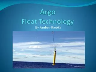
Argofloats – the sea of possibilities Solo Apex/Webb
Argoexpansions and enhancements: • DeepArgo • ExpandingArgocoverageat high latitudes • IncreasingArgocoverage in western boundaryregions • ExpandingArgointo the marginalseas • Bio/BioGeoChemicalArgo
Can we extend Argo to the fast ice zone? This requires consideration of alternative sampling platforms. A number of instruments have been developed for this purpose • Ice Tethered Profilers (ITP) • Polar Ocean Profiling System (POPS) • Acoustically-tracked floats with ice thickness sonars.
Banch of technicalsolutions applied in the high latitudesArgofloats • Two-waycommunication via Iridium (Rudicsprotocol) allowing to modify parking depth and divingdepth • RAFOS antenna (acousticreceiver) allowing to navigateunder the water and icecover • Apassive and an active sea-ice detection capacity • Enhanced power and autonomous memory (morefilescollected and stored) • Strongerantenna
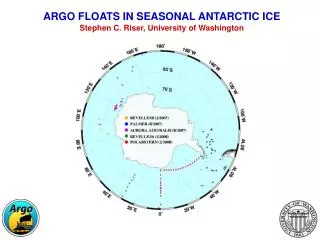
Currentstate and futureplans • Arctic(60-90°N) – 234Argofloatsdeployedsince 2001 (87 declared as deployed in the Arctic Ocean) • 3 acoustic RAFOS sourcesinstalledbetween 2010 and 2011 in the FramStraitunder the ACOBAR project (collaborationbetweenNERSC, AWI, SCRIPPS, OPTIMARE andWHOI) • Antarctic(60-90°S) – 366Argofloatsdeployedsince 2001 • German RAFOS system installed on the underwatermoorings in the Weddel Sea. Used by Universityof Washington, Seattle, USA • Plans: • 360 activefloats in the Southern Ocean (85 floats in the Weddell Sea Gyre and 110 floats in the Ross Sea Gyre – instalation of RAFOS isneeded). • 300 activefloats in the Arctic = 100deployments per year (loss of 20% floatsisestimated)
Limited edition of Argofloats in the Arctic Ocean (red dots in the AO show ITPswhichfinishedtransmission) Source - (JCOMMOPS)
The Canadian 4901101 float, 1831 Days,183 cycles achieved from 2008 to 2013 Source - (JCOMMOPS)
The Southern Ocean – alldeployedfloats Source - (JCOMMOPS)
Closerviewshowsrathersparsecoverage of workingfloats (but betterthan in the Arctic) Source - (JCOMMOPS)
The trajectory of one floatdeployed in the Indian Ocean, 06/01/2005 Source - (JCOMMOPS)
The NordicSeas - complexphysical environment • Atlanticwateradvection, redistribution and recirculation • seaicedrifting and melting, • air-sea-iceinteractionprocesses, • convection and deep water formation, • dense water cascading from the shallow shelf peripheries, • mesoscale features – eddies and fronts, • interleavings and intrusions • smal scalestructures
NordicSeaswatermassesanalysisbased on the Argoprofiles Position of all Argo profiles in the Nordic Seas in the time span 2001 to 2011; the color indicates the deployment basin: green - Norwegian Basin, yellow - LofotenBasin, red - Greenland Sea, blue -Icelandic Plateau. The yellow contur-lines define the areas of the individual basins. Credit: KatrinLatarius, from the SIDERI paper: „Roadmap for evolution of Argo in Europe”
The Greenland Sea characteristic: • isone of the Arctic Ocean constituent seas(IHO definitions: area 898 103km2, volume 1418 103km3and meandepth 1580 m; Jakobsson, 2002), • is at the moment a northern limitfor all Argo floats deployment missions • itsnorthern limit - the FramStraitis the onlydeepconnectionbetweenAtlantic and Arctic Ocean (possible exchange in the deep and intermidiatelayer) • iscovered by ice in the western side and free of ice in the easternsidedue to Atlanticwaterinflow • has a strongboundarycurrents – EGC and WSC • issorrounded by shallowshelvesareasexceptdeepNorwegian Sea on the south • thushas a complicatedwater mass structure
Allplatforms (Argo and ITP)includedthesewhichfinishedits life in the area Source - (JCOMMOPS)
Argofloats in the northernGreenland Sea-active in June 2013 Source - (JCOMMOPS)
Arcticiceextent in Sept 2012 (min) and in Dec 2012 reached by Argo146 in the FramStrait
How to avoid the icecover? Figure credit: B.OWENS & P. WINSOR (WHOI), Oceanus magazine
Techniquesused to detect the ice • Mechanical technique: When the float reaches the surface, if no satellitecommunication can be established, the float considers that sea ice is preventing it from surfacing. • Active acoustic technique: Sea -ice monitoring systems use active acoustic tomeasure, for example, the sea-ice draft. • Passive acoustic technique: passive acoustic (i.e. a hydrophone listening to the ambient noise) can be used for meteorological applications. A hydrophone can be adapted and fitted on a float to detect and characterize sea ice at the surface • Temperature based algorithm:an algorithm calledISA (Ice Sensing Algorithm) to detect sea ice at the surface. This simple algorithm estimates the median of the sea temperature measurements in a profile located between 50 m and 20 m from the sea-surface, and compares it to the freezing point of the seawater (-1.79 °C in Antarctica). If the median value is below the freezing point, then the presence of sea ice is highly probable and the float does not surface. • Optical technique: an optical solution is currently under development
PROV - ULS by NKE during EU Damocles project (2006 – 2009) These floats wereequipped with high accuracypressure sensors (Digiquartz Paroscientific), RAFOS (Ranging And Fixing Sound) transducers for reception andtransmition, as well as an acoustic communication system Credit NKE
Ourlocation: Sopot, Poland, The southern Baltic Sea coast Institute of OceanologyPolishAcademy of SciencesPhysicalOceanographyDepartment Ourship: RV „Oceania”
The IO PAS deployed 9 floats (5 from Argo Poland) between 2009 and 2013 from the RV„Oceania”
Trajectories of 3 Nemofloats with ISAdeployed by IOPAS whichcirculated in the northernGeenland Sea
Structure of the Greenland Sea watermasses in the 600 dbarupperlayer T, S and densitydistribution from Argo 146 (111 profiles) deployed in June 2010 and Argo 223 (56 profiles) deployed in July 2012
The watermasses θS-diagrams based on data from twoArgo floats deployed in 2010and2012 (Water masses classification based on Rudels et al, (2005): PolarSurface Water, Warm SurfaceWater, Atlantic Water, Arctic Atlantic Water, Arctic Intermediate Water, upper Polar Deep Water andNordic Seas Deep Water)
Thankyou! Poland in the Argo network: • Euro-Argo RI (EU ResearchInfrastructure) • SIDERI – „Strengthening International Dimension of Euro-Argo Research Infrastructure” • E-AIMS – „Euro-Argo Improvements for the GMES Marine Service” • in connection with the IOPAS Arctic Experiments AREXaboard R/V Oceania performed in summer2009-2012.