Download
1 / 16
160 likes | 320 Vues
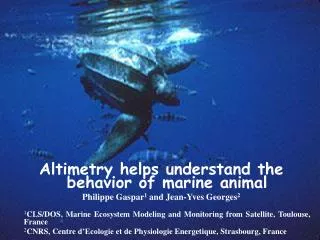
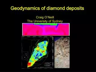
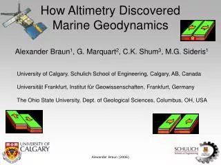
How Altimetry Discovered Marine Geodynamics. Alexander Braun 1 , G. Marquart 2 , C.K. Shum 3 , M.G. Sideris 1. University of Calgary, Schulich School of Engineering, Calgary, AB, Canada Universit ät Frankfurt, Institut für Geowissenschaften, Frankfurt, Germany

E N D
How Altimetry Discovered Marine Geodynamics Alexander Braun1, G. Marquart2, C.K. Shum3, M.G. Sideris1 University of Calgary, Schulich School of Engineering, Calgary, AB, Canada Universität Frankfurt, Institut für Geowissenschaften, Frankfurt, Germany The Ohio State University, Dept. of Geological Sciences, Columbus, OH, USA Alexander Braun (2006)
Geodynamic processes in the marine environment and beneath Subduction, sea-floor spreading, rifts and faults, sedimentary basins, shelfs, COB, boudinage, crust-mantle interaction No field geology available, only some drillings and submarine/ship surveys Marine Geodynamics Alexander Braun (2006)
Marine Geodynamics Sandwell and Smith, 1997 Alexander Braun (2006)
Satellite Altimetry Altimetry Bathymetry SSH/Geoid/VD Gravity anomalies Alexander Braun (2006)
The Geodetic Mission of ERS-1 and GEOSAT have been the most important contributions to marine geodynamics Spatial resolution is high, temporal resolution is low, but static gravity field information is required only However, knowledge of the static gravity field today allows insights in dynamic processes of the lithosphere and crust Satellite Altimetry Alexander Braun (2006)
“incomplete” Historic overview of applications • Haxby, W. F., G. D. Karner, J. L. LaBrecque and J. K. Weissel, Digital Images of Combined Oceanic and Continental Data Sets and Their Use in Tectonic Studies, EOS Trans.1983. • Sandwell, D. T., and G. Schubert, Geoid Height-Age Relation from Seasat Altimeter Profiles across the Mendocino Fracture Zone, J. Geophys. Res., 1982 • Coffin, M.F., Davies, H.L., and Haxby, W.F., 1986. Structure of the Kerguelen Plateau province from Seasat altimetry and seismic reflection data, Nature, 1986 • Anderson, A., Marquart, G., Scherneck, H.-G., Arctic Geodynamics: A Satellite Altimeter Experiment for the ESA ERS-1, EOS Transactions, 1988. Haxby, National Geographic, 1983 Alexander Braun (2006)
“incomplete” Historic overview of applications • McAdoo, D. and S. Laxon, Antarctic Tectonics: Constraints From an ERS-1 Satellite Marine Gravity Field, Science, 1997 • Sandwell, D. T., W. H. F. Smith, Marine gravity anomaly from Geosat and ERS 1 satellite altimetry, J. Geophys. Res, 1997 • Smith, W. H. F., and D. T. Sandwell, Global seafloor topography from satellite altimetry and ship depth soundings, Science, 1997 • Géli L., and Blanc, F., Mapping the sedimentary basins of the Barents seaand Kara Seas using ERS-1 altimetry-geodetic mission. Marine Geophys. Res., 1998 Alexander Braun (2006)
Selected examples: North Atlantic Braun, A., Marquart, G., Evolution of the Lofoten-Vesterålen margin inferred from gravity and crustal modelling, J. Geophys. Res., 2004 Alexander Braun (2006)
Selected examples: North Atlantic Alexander Braun (2006)
Selected examples: North Atlantic Alexander Braun (2006)
Selected examples: North Atlantic Alexander Braun (2006)
Selected examples: South China Sea Alexander Braun (2006)
Selected examples: East Pacific Marquart, G., Schmeling, H., Braun, A., Small-scale instabilities below the cooling oceanic lithosphere, Geophys. J. Int., 1999 Filtered 10-1000 km 27 Ma 2 Ma East pacific rise ERS-1 GM derived gravity anomalies Alexander Braun (2006)
Selected examples: East Pacific ridge Results Dynamic processes • random pertubations (e.g. FZ) • Rayleigh Taylor instabilities • Thermal diffusion • Lithospheric thickening • Richter rolls normal to ridge • wavelength of RTI grows with age • or lithospheric thickness • lithosphere viscosity of 2*10^19 Pa s • astenosphere viscosity of 1*10^17 Pa s • Creates RTI with wavelengths of 150- • 250 km comparable to observations • Model explains the wavelengths of • Richter rolls Alexander Braun (2006)
Crustal vertical motion Great Lakes Kuo, C.Y, Shum, C.K., Braun, A., Mitrovica, J., Vertical crustal motion inferred by satellite altimetry and tide gauge data in Fennoscandia, GRL, 2004. Alaska Fennoscandia Alexander Braun (2006)
Altimetry revolutionized marine geodynamics Altimetry data assist in geodynamic interpretation and modelling Gravity and bathymetry are the most fundamental parameters in marine geodynamics Need for higher spatial resolution (ABYSS) Need for better coverage close to the coast Thanks to all altimetry agencies, operations and processing centres! Summary and Outlook Alexander Braun (2006)