Space remote sensing for urban damage detection mapping and mitigation
20 likes | 287 Vues
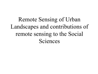
EQ at time t 0. OPTICAL pre-seismic. OPTICAL post-seismic. SAR-SLC t 0 +1 post-seismic. SAR-SLC t 0 -1 pre-seismic. SAR-SLC t 0 -2 pre-seismic. Pre-seismic complex coherence Pre-seismic intensity correlation Co-seismic complex coherence Co-seismic intensity correlation Change image.

Space remote sensing for urban damage detection mapping and mitigation
E N D
Presentation Transcript
EQ at time t0 OPTICAL pre-seismic OPTICAL post-seismic SAR-SLC t0+1 post-seismic SAR-SLC t0-1 pre-seismic SAR-SLC t0-2 pre-seismic Pre-seismic complex coherence Pre-seismic intensity correlation Co-seismic complex coherence Co-seismic intensity correlation Change image Dataset composition: co-registration geo-coding Change image Auxiliary data Damage classification procedure & Layers production Space remote sensing for urban damage detection mapping and mitigation Salvatore Stramondo1, Nazzareno Pierdicca2, Marco Chini3, Christian Bignami1 1 Istituto Nazionale di Geofisica e Vulcanologia,Via di Vigna Murata 605, 00143, Rome, Italy. stramondo@ingv.it, bignami@ingv.it 2 Dept. of Electronic Engineering, Sapienza Univ. of Rome, Via Eudossiana 18, Rome, Italy. pierdicca@mail.die.uniroma1.it 3 Dept. of Physics, Univ. Alma Mater Studiorum of Bologna, Viale C. Berti Pichat 8, Bologna, Italy. chini@ingv.it Introduction In the last years the remote sensing techniques have been demonstrated a suitable monitoring tool for providing data useful for disaster mitigation. In particular, in case of strong earthquake, the rapid detection of damaged buildings and infrastructures has assumed an important role for the civil protection rescue activities. Moreover, the damage assessment can help the redevelopment process of the hit area. SAR has been revealed a powerful instrument for change detection and damage evaluation purpose. In particular, interferometric features like the InSAR phase coherence and the intensity correlation of multi-look images collected before and after an earthquake can be used to detect and quantify changes in built-up area. On the other side, optical sensors have also been successfully used for damage estimation. In fact, the new optical sensors are reliable systems for detecting changes of single buildings. However, the presence of clouds, shadows, variation in Sun illumination and geometric distortions are critical for this type of sensors and prevent a fully automatic change detection approach. When both optical and SAR are available, a damage classification can also be obtained by combining the two data types, leading to a more reliable result. This work proposes an effective procedure oriented to the damage mapping. From data requirements (satellite images and auxiliary data) to product delivery the chain for damage mapping is described. This latter in order to provide new instruments useful to Civil Protection Departments and Administrations for disaster management. Data requirements • The minimum configuration to perform a damage level estimation can be summarised as follow: • SAR data • Two pre-seismic acquisition • One post-seismic acquisition • OPICAL data • One pre-seismic and one post-seismic • Auxiliary data • local cartography • DEM • The damage evaluation products can be also generated by SAR data alone or by optical data alone Optical Processing • Two images taken one pre- and one post-seismic event. • Co-registration of the images. • Extraction of the other information from the image before the earthquake in order to have more input for the building classification, especially when we deal with panchromatic images, just one band. • Building classification of the image before the earthquake for limiting the analysis of changes just at this feature in order to reduce the possible false alarms caused by temporary objects (e.g. shadows, cars, vegetation). • Change detection procedure using both images on the building map which is based on the pre-seismic image. Data acquisition strategy Data collection has to be done as frequently as possible. In particular a systematic approach of the acquisition over high risk seismic area is preferable This approach is intended to create a catalogue, of both SAR and optical data, composed by images as current as possible, in order to avoid false alarm in the damage detection caused by urban development between pre-seismic and post-seismic acquisitions SAR processing SAR images are processed in order to obtain two main SAR features: the complex coherence and the intensity correlation. The first one is calculated from the single look complex data by means of: The second one is evaluated from multi look data as follows: where s1 and s2 are the corresponding complex pixel values, I1 and I2 are corresponding pixel values of the intensity, and E() indicates the expected value. Pre-seismic features are obtained combining two pre-seismic acquisitions whereas the co-seismic ones are derived using one pre- and one post-event acquisition Damage evaluation approaches • The possible approaches for damage evaluation can be separated in: • Optical: when only optical data are available change detection procedure give the map of damages at different scale, depending on the ground resolution of the sensors. • SAR: when only SAR data are available, the difference between SAR features (complex coherence and intensity correlation) is analysed • SAR & Optical: data fusion by classification algorithms both parametric and non-parametric. Product delivery