Download
1 / 1
20 likes | 158 Vues
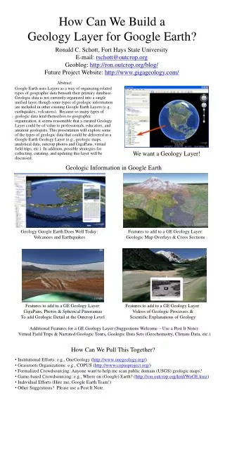
Ronald C. Schott, Fort Hays State University E-mail: rschott@outcrop.org Geoblog : http://ron.outcrop.org/blog/ Future Project Website: http://www.gigageology.com/. How Can We Build a Geology Layer for Google Earth?. We want a Geology Layer!. Geologic Information in Google Earth.

E N D
Ronald C. Schott, Fort Hays State University E-mail: rschott@outcrop.org Geoblog: http://ron.outcrop.org/blog/ Future Project Website: http://www.gigageology.com/ How Can We Build aGeology Layer for Google Earth? We want a Geology Layer! Geologic Information in Google Earth Geology Google Earth Does Well Today: Volcanoes and Earthquakes Features to add to a GE Geology Layer: Geologic Map Overlays & Cross Sections Abstract Google Earth uses Layers as a way of organizing related types of geographic data beneath their primary database. Geologic data is not currently organized into a single unified layer, though some types of geologic information are included in other existing Google Earth Layers (e.g., earthquakes, volcanoes). Because so many types of geologic data lend themselves to geographic organization, it seems reasonable that a curated Geology Layer could be of value to professionals, educators, and amateur geologists. This presentation will explore some of the types of geologic data that could be delivered in a Google Earth Geology Layer (e.g., geologic maps, analytical data, outcrop photos and GigaPans, virtual field trips, etc.). In addition, possible strategies for collecting, curating, and updating this layer will be discussed. Features to add to a GE Geology Layer: GigaPans, Photos & Spherical Panoramas To add Geologic Detail at the Outcrop Level Features to add to a GE Geology Layer: Videos of Geologic Processes & Scientific Explanations of Geology Additional Features for a GE Geology Layer (Suggestions Welcome – Use a Post It Note): Virtual Field Trips & Narrated Geologic Tours, Geologic Data Sets (Geochemistry, Climate Data, etc.) How Can We Pull This Together? • Institutional Efforts: e.g., OneGeology (http://www.onegeology.org/) • Grassroots Organizations: e.g., COPUS (http://www.copusproject.org/) • Formalized Crowdsourcing: Anyone want to help me scan public domain (USGS) geologic maps? • Game-based Crowdsourcing: e.g., Where on (Google) Earth? (http://ron.outcrop.org/kml/WoGE.kmz) • Individual Efforts (Hire me, Google Earth Team!) • Other Suggestions? Please use a Post It Note.