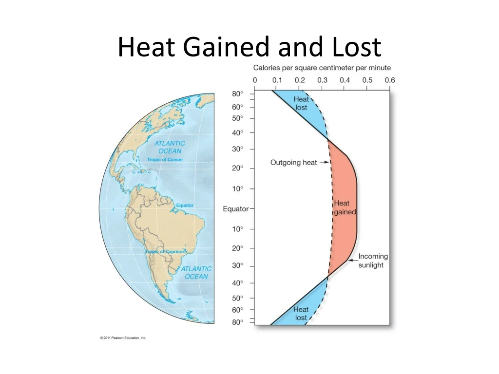
Heat Gained and Lost
380 likes | 410 Vues
Discover the intricate workings of ocean circulation cells, wave dynamics, and tidal forces in this comprehensive exploration. Learn about the Ekman transport, coastal upwelling, types of waves, tsunami formation, tidal cycles, and more.

Heat Gained and Lost
E N D
Presentation Transcript
Circulation Cells – one in each hemisphere • Polar Cell: 60–90 degrees latitude • Ferrel Cell: 30–60 degrees latitude • Hadley Cell: 0–30 degrees latitude
Ekman Transport Average movement of seawater under influence of wind 90 degrees to right of wind in Northern hemisphere 90 degrees to left of wind in Southern hemisphere
Coastal Upwelling Ekman transport moves surface seawater offshore. Cool, nutrient-rich deep water comes up to replace displaced surface waters. Example: U.S. West Coast
Coastal Downwelling Ekman transport moves surface seawater toward shore. Water piles up, moves downward in water column Lack of marine life
CHAPTER 8 Waves and Water Dynamics • Wave Types (transmit energy not matter) • Wave Terminology (the battle of the crests vs. troughs) • Types of Ocean Waves (Deep vs. Shallow) • Breakers (transitioning waves) • Wave Refraction • Tsunami
Orbital Waves • Frequency = 1/Period • Frequency = The number of wave crests that pass one location per unit of time. • Period = The time required for 1 wave crest to pass one location. • Crest vs. Trough • Wavelength WH • Wave height WL • Wave Steepness = WH/WL
Circular Orbital Motion • Wave particles move in a circle
Transitional Waves Characteristics of both deep- and shallow-water waves Velocity depends on both water depth and wavelength
Ocean Continent Subduction • Subduction zone earthquakes can generate tsunami USGS
CHAPTER 9 Tides • Causes: Gravitational and Centripetal Forces • Tidal Bulges: Lunar and Solar • Idealized vs. Complicated Factors • Idealized Tide Prediction • How do tides vary globally?
Gravitational Forces Greatest force at zenith – closest to moon Least force at nadir – furthest from moon and opposite zenith
Centripetal Force Center-seeking force Tethers Earth and Moon to each other
Resultant Forces Mathematical difference between gravitational and centripetal forces Relatively small
Tide-Generating Forces • Resultant force has significant horizontal component • Pushes water into two simultaneous bulges • One toward Moon • One away from Moon
Tidal Bulges – Moon’s Effect Small horizontal forces push seawater into two bulges. Opposite sides of Earth
Earth’s Rotation and Tides • Flood tide – water moves toward shore • Ebb tide – water moves away from shore • Tidal bulges are fixed relative to the Sun’s and Moon’s positions • Earth’s rotation moves different geographic locations into bulges
Earth, Moon, and Sun Positions Relative to Spring and Neap Tides
Declination and Tidal Bulges (Complicating Factors) • Declination – Angular distance of the Moon or Sun above or below Earth’s equator • Sun to Earth: 23.5 degrees north or south of equator • Moon to Earth: 28.5 degrees north or south of equator • Lunar and solar bulges shift from equator • Unequal tides
Monthly Tidal Curves • Diurnal • One high tide/one low tide per day • Semidiurnal • Two high tides/two low tides per day • Tidal range about same • Mixed • Two high tides/two low tides per day • Tidal range different • Most common