Geography Trivia Questions - Week 7
40 likes | 97 Vues
Test your geography knowledge with these questions about capitals, locations, and geographical facts from around the world. Each day focus on a new set of questions.

Geography Trivia Questions - Week 7
E N D
Presentation Transcript
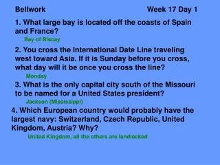
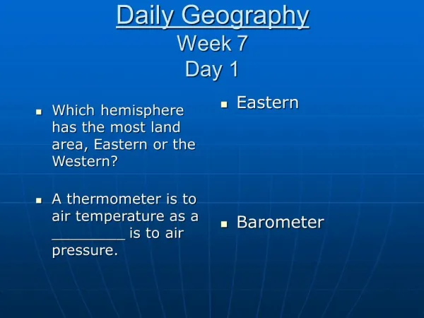
Bellwork Week 7 Day 1 1. What is the capital of the nation that is the southern border of the world’s largest lake? Teheran (Iran) 2. What coastal city is found at 17 degrees N and 100 degrees W? Acapulco (Mexico) 3. Who usually gets to start a new day first- residents of Paris, France, or Budapest, Hungary? Why? Budapest, Hungary. Because of the Earth’s rotation from west to east 4. Which Central America country has the smallest land area? El Salvador
Bellwork Week 7 Day 2 1. What Greek island is located approximately 25 degrees E and 33 degrees N? Crete 2. What is the capital of the nation composed of 13,500 islands northwest of Australia, and through which the equator passes? Jakarta (Indonesia) 3. What delta is at the southern end of the Indochina Peninsula? Mekong 4. What is the capital of Zaire? Kinshasa
Bellwork Week 7 Day 3 1. Approximately what percentage of the water on the Earth is fresh water: 1%, 3%, 19%, 37%? 3% 2. What two lines of longitude separate the Eastern and Western Hemispheres? Prime Meridian, at 0 degrees, and the International Date Line, at 180 degrees 3. On a physical map, what color usually denotes high elevations: green, brown, yellow? Brown 4. Through what oceans does the equator pass? Atlantic, Indian, Pacific
Bellwork Week 7 Day 4 1. What is elevation? The height of land above sea level 2. What are at least three symbols you would find on a map? Symbols for cities, capitals, boundaries, and rivers etc. 3. What are the oceans of the world arranged according to size from largest to smallest? Pacific, Atlantic, Indian, Arctic 4. What oceans touch Europe? Arctic, Atlantic