Chapter 2: United States and Canada
790 likes | 1.02k Vues
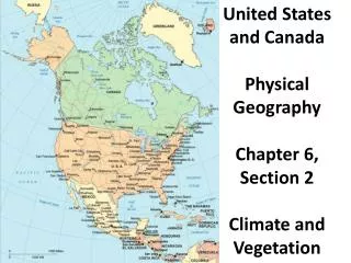
Chapter 2: United States and Canada. Landform Geography. Both are on the North American continent. Crustal mass includes Mexico and Central America. Many generalizations can be made also to Mexico and Central America. Land Surface Regions of US & Canada. The Canadian Shield. Shields

Chapter 2: United States and Canada
E N D
Presentation Transcript
Landform Geography • Both are on the North American continent. • Crustal mass includes Mexico and Central America. • Many generalizations can be made also to Mexico and Central America.
The Canadian Shield • Shields • Piece of Earth’s crust that is very old and geographically very stable • Probably cannot be further revised • Cultural nuclei around which mountain formation tends to occur • Canadian Shield • Extends outward from the Hudson Bay • Includes much of Quebec & Labrador • Most of Ontario & Manitoba • Substantial part of Canadian Arctic
Appalachian Highlands and Lowlands • Highlands • Low-lying mountains from Newfoundland down to Alabama • Six distinct landforms: • Piedmont—PA southward to GA • Fall Line—Series of river and stream rapids that mark the edge of the Piedmont where it descends on the coastal plain • Blue Ridge Mountains—NC, TN, and GA (also called Great Smokies) • Ridge and Valley province • Folded landscape of long, parallel ridges and valleys from NY to northern AL • Includes Hudson and Shenandoah Valleys • Appalachian Plateau—Western portion of Appalachian Highlands • New England • White Mountains of NH and ME • Green Mountains of VT • Continues into Canada to form a Maritimes-Newfoundland extension
Gulf-Atlantic Coastal Plain • Gulf of Mexico to US Atlantic Coasts • Expanse • Cape Cod to Florida • FL • Coastal TX • Much of lower Mississippi Valley
Western Mountains and Plateaus • Rocky Mountains—Northern NM northward to CO and WY • Interior Plateau • West of the Rocky Mountains • Transition between Rockies and Pacific Coastlands
Western Plateaus—Components • Colorado Plateau—More than a mile high in SW CO, eastern UT, northern AZ, NM • Basin and Range • West and south of the CO Plateau • Much of NV and western UT, parts of southern CA and AZ • Columbia Plateau • North of Basin and Range • Eastern OR and WA • Snake River area of ID • Pacific Coastlands • Sierra Nevada Mountains • North to south in eastern CA • Eleven peaks in excess of 14,000 feet • Cascade Mountains • North of Sierra Nevada • Central OR and WA • Coast Ranges—Length of the Pacific Coast • Great Valley—Alluvial trough • Willamette Valley (OR) • Puget Sound Lowland (WA)
Interior Lowlands • South and west of the Canadian Shield • Between North America’s backbones of east and west • Components • Great Plains—East of the Rocky Mountains • Great Lakes—MI, NY, and Ontario • Ozark Plateau—MI • Ouachita Mountains—AK • Black Hills • Western SD • Peaks that exceed 7,000 feet
Climate • Several influencing factors: • Clearly defined changes in seasonal temperatures • Prevailing wind direction is west to east. • North–south mountain ranges in the west modify air masses as they move east. • Continentality—Atmosphere takes on the more extreme heating and cooling characteristics of land than water. • Winters—Cold • Summers—Hot • Gulf of Mexico—Important source of moisture for the Gulf Coast and Interior Lowlands • Characteristics: • Humid subtropics • Dry subtropics • Marine west coast • Western steppes and deserts • Humid continental • Subarctic and polar climates
Humid Subtropics • Hot and sticky • Northward to southern Middle Atlantic and mid-western states
Dry Subtropics (Mediterranean) • Pacific Coast • San Diego to San Francisco • Summers relatively cool (time of drought) • Winters relatively warm • Precipitation low, but clearly defined wet and dry seasons • Snow virtually unheard of
Marine West Coast • Northern CA to Alaska • Winter—Warmer due to moderating effects of ocean • Summer—Cool • Cascade mountains produce a moderating effect.
Western Steppes and Deserts • Eastern OR and WA south to Colorado Plateau • East of Rocky Mountains—Corresponds roughly to the Great Plains • Semiarid climate • Temperatures tend toward extremes • True deserts of North America concentrated in the southwest: • Southern TX • Southern AZ • Southern CA
Humid Continental • Northern part of US into southern Canada • Humidity • Winter—Cool to cold • Summer—Can be very hot • Home to America’s agricultural heartland • Corn Belt • Dairy Belt
Subarctic and Polar • Subarctic • Wide swath of central Canada and Alaska • Precipitation levels low—Mostly as summer rain • Polar • Northern edges of Canada and Alaska • Freezing conditions most of the year • Some days without sunlight
Culture Cores • Geographers study settlement trends. • Several dynamics studied by geographers: • Culture hearths • Centers of cultural innovation • Take innovations across landscape through diffusion • Diffusion process—Settlers moving into new territories • Settlement frontiers—Areas where settlers develop • Spatial integration—Result of settlers transforming the settled landscape
US & Canada—European Core Influences • New England—MA, RI, and CT • Originally a destination for religious freedom • Artisanal work • Shipbuilding • Southern Atlantic—VA and southward • Cultivation of subtropical crops—notably tobacco • Plantation system a major aspect of work by smaller farms • Middle Atlantic—NY, PA, and parts of NJ and MD • English, Dutch, Scots–Irish, and Swedish influences • Mixed agricultural system • Manufacture of tools, guns, and wagons • Iron ore work in PA • Influential impact of American middle west and parts of Appalachians • French Canada—Quebec; St. Lawrence River area • Early settlers were French; British took over in 1763. • Some farming along St. Lawrence River • French Canadian population has remained contextual; little spatial diffusion.
Expansion—Manifest Destiny • View of US that all land on the continent willed by God to the US to be civilized by Americans and their ennobling institutions • Enabled by dominant international political culture • Expansion of US • Louisiana Purchase—1803 • East Florida—1819 • West Florida—1810-1813 • Texas—Annexed in 1845 • Mexican Cession—1848 • Oregon County—1848 • Gadsden Purchase—1853
Trends in Canada • Loyalists—Remnants of supporters of the British following the American Revolution • Created a counterweight to French-speaking Quebec • Anglicization process would eventually displace the French to minority. • July 1, 1867—Canada officially becomes a country. • American-style federalism (confederation of provinces) • British-style Parliament • House of Commons • Senate
Other Factors Impacting Expansion • Transformation in transportation technologies • Need to overcome friction of distance • Canal building • Railroads
Immigration • Both US and Canada impacted historically. • Zelinsky—Two categories of US immigration: • 1607 to 1775—European migrants and African as slaves • 1820 to present—The “national” era • 1820 to 1870—Heavily British, Irish, German, and Dutch; some Latin Americans and Asians • 1870 to 1920—“Great Deluge” • 26 million people emigrate to US • Traditional northwestern European sources • Scandinavia • Eastern and southern Europe, China, Japan, and Latin America • 1920 to present—Miscellaneous: • Wide variety of origins • Especially Asians and Latin Americans
Canadian Immigration • Just as intense and nation-altering as US • Started later • Prior to confederation • British • American Loyalists • French (Quebec) • 1885—Railroads to Canadian Prairies finished • Many claims on land • Eastern Europeans • Scandinavian countries • Britain and US • Population increased by one-third in the first half of the twentieth century. • After World War II, primarily immigration to urban areas (increasing concentrations of Asians and Africans)
Demographics • US population growth after 1800 • High birthrates (fertility rates) • Low death rates (mortality rates) • Immigration • Canadian population growth • Grew mainly by natural increase between 1867 and 1900 • But limited by a low fertility rate • Population distribution • Predominantly east of the Mississippi River • Greatest concentration in northeast quadrants • US—North central, northeast • Canada: • Within 200 miles of US border between Windsor, Ontario and Quebec City, Quebec • Vancouver, Victoria, and British Columbia
Population Redistribution • Changes in economies • Agrarian to industrial economies (1800s) • US • Development of manufacturing in cities • Transformation from plantation system due to mechanization of farming • Canada • Development of petroleum reserves (Alberta) • International and interprovincial migration (British Columbia)
Factors Influencing Success of Agriculture • Abundance of good land • 1.5 of all land in US is classified as cropland. • Canada’s small population relative to the US means the ration of farmland to people is about the same. • High level of mechanization • Tractors replace mules. • Hybrid seeds, pesticides, herbicides, biotechnology, and scientific farming techniques • Regional specialization • A variety of environmental conditions • Need for developing comparative advantage
Agricultural Regions • Corn Belt • Dairy Belt • Specialty Crop and Livestock Region • Great Wheat Belts • Western farming
Corn Belt • Location—Central OH to eastern NB; MN to SD; southern into KS • Corn useful for multiple purposes • Food for people • Feed for animals • Area began as a mixed farming area, with equal emphasis on crop cultivation and livestock production.
Dairy Belt • Location—North of the Corn Belt, stretching westward from Nova Scotia and New England to WI and MN • Conditions less favorable for agriculture • Soils thinner/less fertile • Growing seasons shorter • Two types of production
Specialty Crop & Livestock Production • Location—Southern New England to eastern TX • Wide array of activities • City dwellers demanded fruits and vegetables. • Truck farming • High value • Land intensive • Market-oriented • South • Livestock region • Poultry farms
Great Wheat Belts • Winter Wheat Belt • KS, OK, CO, and north TX • What planted in fall, lies dormant in winter, and is harvested in spring. • Used for spaghetti, crackers, and pastries • Spring Wheat Belt • ND, SD, MT, and Saskatchewan • What planted in spring and is harvested in late summer • Used for bread
Western Farming • Water is the big issue. • Dry soils can be tilled with water from underground aquifers. • Irrigation, however, is not necessary in the Pacific Northwest. • Ranches are very large. • Many cases exceeding 100,000 acres • Typically used for livestock
Continuing Adjustments in Agriculture • Fewer farmers • Growth of agribusiness/vertical integration • Death of family farming • Rise of corporate farming • Fewer, larger farms • Rural geography changing • Now a coarse series of large corporate holdings • Greater increase in supply than in demand • Farm output has increased. • Demand has not kept pace.
Resources for Growth & Development: Energy & Power • Coal • Major energy source for industrial expansion in US, WY, KY, WV, and PA • Nova Scotia, New Brunswick in Canada • Easier to import from US Appalachian states • More emphasis on petroleum • Oil and gas • Both US and Canada are major producers and consumers. • US—Production centered in TX, LA, KS, CA, and AL • Canada—Alberta and Saskatchewan • Water • 60% energy via hydroelectricity in Canada • 8.5% in the US • Nuclear • 20% source of power in US • 12% source of power in Canada
Resources for Growth & Development: Metals • Iron ore • US and Canada are major producers and consumers. • Canada—Exporter • US—Importer • Aluminum • Used extensively in transportation and construction • Bauxite required • Not readily available here. • Import from Jamaica, Suriname, Guyana, and Australia • Canada produces some other metals: • Nickel • Copper
Coal and Iron Ore in US & CanadaPetroleum & Natural Gas in US & Canada
Manufacturing in the US • New England • Waterways • Railroads • South • Remote from transportation • Produced for exporting • Coreland • Southern New England • Textile • Leather-working • Machine tools • Metro New York • Diversified manufacturing • Garment industry
Three Prominent Steel Industries • First • Baltimore, MD • Bethlehem, PA • Philadelphia, PA • Harrisburg, PA • Second • Erie, PA • Pittsburgh, PA • Toledo, OH • Third • Gary, IN • Chicago, IL • Milwaukee, WI
Automobile Manufacturing • Southern MI • Parts of IN, OH, and Ontario • Automobile production • Parts and assembly
Problems Facing Coreland Manufacturing • Intensive foreign competition • Labor costs cheaper • More modern equipment • Difficult economic conditions • Recessions • Fluctuations • Social problems • Social conflict • Air and water pollution • Residential quality • Urban water supply
Southern Economic Revolution • Textiles are the first major industry. • Grew to have a comparative advantage • Cheaper labor costs than in the north • Better locations • Lower power costs • Lower taxes • Other industries • Material-oriented pulp and paper • Furniture • Food processing • Forest industries • Petroleum (Gulf Coast) • Steel (Birmingham, AL and Atlanta, GA) • Grew into a significant regional market
Canadian Manufacturing • Location—St. Lawrence Seaway and Ontario • Industrial heartland • Montreal the center of industry—Akin to NYC • Specialization elsewhere • Hydroelectric potential—Quebec • Golden Horseshoe • Most of Canada’s steel • Great variety of other goods • Protected by tariff • Drift westward • Alberta and western provinces gain • Similar trends to US