Fire Danger
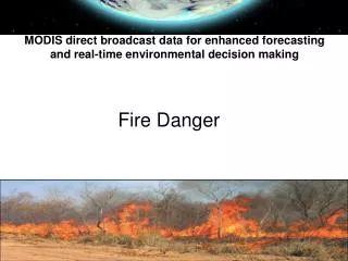
Fire Danger. MODIS direct broadcast data for enhanced forecasting and real-time environmental decision making. Fire Danger Research. What is Fire Danger?

Fire Danger
E N D
Presentation Transcript
Fire Danger MODIS direct broadcast data for enhanced forecasting and real-time environmental decision making
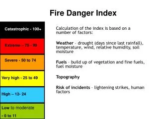
Fire Danger Research • What is Fire Danger? • A general term used to express an assessment of fixed and variable factors of the fire environment that determine the ease of ignition, rate of spread, difficulty of control and fire impact • Components: weather, topography, fuel • What is Fire Danger Rating (FDR)? • The process of systematically evaluating and integrating the individual and combined factors influencing fire danger represented in the form of fire indices • What is a Fire Danger Index (FDI)? • A quantitative indicator of one or more facets of fire danger expressed in a relative sense or as an absolute measure
Applications or uses of Fire Danger Ratings • Prevention planning • Preparedness planning • Detection planning • Formulating of suppression plans • Planning of initial attack • Evaluating safe work practices • Prescribed burning planning • Fire and fuel management planning
Potential of Remote Sensing/GIS Fuel - Type: Optical sensors, radar and lidar • Moisture (Live fuels): Optical data (MODIS/Landsat) Slope: Lidar, interferometric radar Human Ignition factors Vulnerability: • Socio-economical: Houses, power lines • Ecological: Degradation, erosion Validation: Hot spot detection/ Burned area products
International Operational FDRS • 11 countries of 14 represented uses the Fire Weather Index (FWI) of the Canadian Forest Fire Danger Rating System (CFFDRS) • Argentina, Canada, Croatia, China, EU, UK, Indonesia, Malaysia & SE Asia, New Zealand, Peru, Spain • Exceptions: • USA (United States National Fire Danger Rating System, FireFamily Plus tools) • Russia (NOAA data & Nesterov’s equation) • South Africa (Lowveld Model) • Australia (McArthur Forest & McArthur Grassland Fire Danger Indices)
South Africa • DWAF attempted to implemented the US NFDRS • Operational Lowveld FDR used by WoF, Eskom and provided to Fire protection Agencies (FPA) • Based on McArthur Grassland FDR and adaption of a Fire Hazard Index developed by Michael Laing. Further developed by Winston Trollope • FDI can be calculated by using handheld weather instrument (Kestrell)
Key Assumptions within the National Fire Danger Rating System • It relates only to the potential of an initiating fire, one that spreads, without crowning or spotting, through continuous fuels on a uniform slope. • It addresses fire activity from a containment standpoint as opposed to full extinguishment. • The ratings are relative, not absolute and they are linearly related. In other words if a component or index doubles the work associated with that element doubles. • Ratings represent near worst-case conditions measured at exposed locations at or near the peak of the normal burning period.
National Fire Danger Rating System Terminology • Live Fuels – Naturally occurring fuels whose moisture content is controlled by the physiological processes within the plant. The National Fire Danger Rating System considers only herbaceous plants and woody material small enough (leaves, needles and twigs) to be consumed in the flaming front of a fire. • Dead Fuels – Naturally occurring fuels whose moisture content is governed by external factors such as temperature, relative humidity and precipitation. • Timelag – The time necessary for a fuel particle to lose approximately 63 percent of the difference between its initial moisture content and its equilibrium moisture content. • 1 Hr Timelag Fuels – Dead fuels consisting of herbaceous plants or roundwood less than one-quarter inch in diameter. Also included is the uppermost layer of litter on the forest floor. • 10 Hr Timelag Fuels – Dead fuels consisting of roundwood in the size range of one quarter to 1 inch in diameter and very roughly, the layer of litter extending from just below the surface to three-quarters of inch below the surface. • 100 Hr Timelag Fuels – Dead fuels consisting of roundwood in the size range of 1 to 3 inches in diameter and, very roughly, the forest floor from three quarters of an inch to 4 inches below the surface. • 1000 Hr Timelag Fuels – Dead fuels consisting of roundwood 3 to 8 inches in diameter or the layer of the forest floor more than about 4 inches below the surface or both.