Chapter 4: Marine Provinces
200 likes | 559 Vues
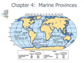
Chapter 4: Marine Provinces. Seismic profiling. Fig. 4-4. Hypsographic curve. Average depth of ocean 3729 m Average height of continents 840 m. Fig. 4-5. Continental margins. Shallow ocean close to land Underlain by continental crust Classified as passive or active. Passive margins.

Chapter 4: Marine Provinces
E N D
Presentation Transcript
Seismic profiling Fig. 4-4
Hypsographic curve • Average depth of ocean 3729 m • Average height of continents 840 m Fig. 4-5
Continental margins • Shallow ocean close to land • Underlain by continental crust • Classified as passive or active
Passive margins • Not a plate boundary • Not tectonically active • Continental shelf • Continental slope • Continental rise
Active margins • At plate boundaries • Tectonically active • Classified by type of plate boundary
Continental shelf • Coast to shelf break (average depth 135m) • Generally flat • May be narrow or wide • Average width 70 km • Active margin narrower • Passive margin wider
Continental slope • Extends from shelf break to deep ocean • Gradient ranges from 1-25o • Average gradient 4o • Relief greater at active margin • Submarine canyons • Turbidity currents
Continental rise • Transition between continental margin and deep ocean • Sediments deposited by waning turbidity currents • Not common convergent active margins • Rise only exists where sediments can accumulate
Deep ocean basin • Underlain by oceanic crust • Seaward of continental margin • Abyssal plains very flat • Fine-grained sediments deposited • Volcanic seamounts, tablemounts, abyssal hills
Mid-ocean ridge • 75,000 km long • Covers 23% of Earth’s surface • Rift valley at crest • Site of magma (pillow basalts) • Hydrothermal vents • Warm water • White smokers • Black smokers
Hot vent communities • Chemosynthetic autotrophs Metal sulfide deposits
Ocean ridge • Steeper, rugged, prominent rift valley • Ocean rise • Gentler, less rugged, less well-defined rift valley • Fracture zones • Aseismic scars, extensions of transform faults