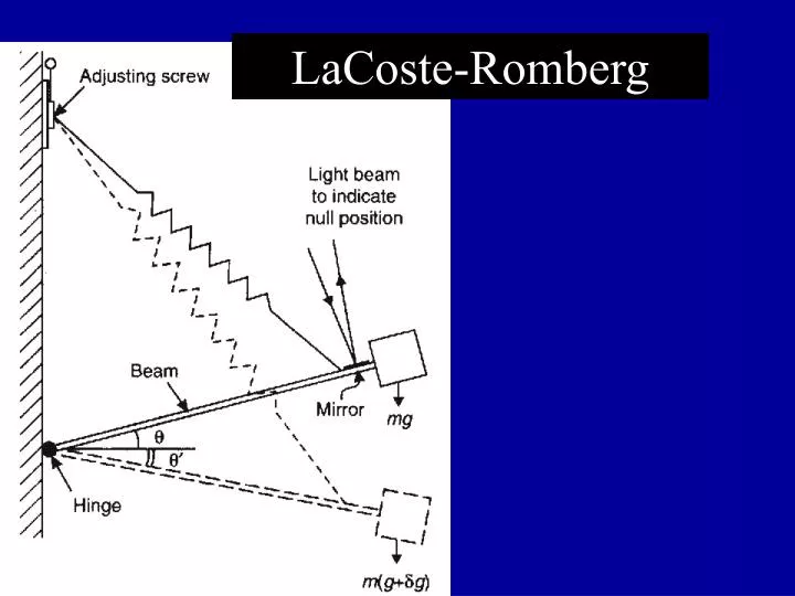

LaCoste-Romberg
E N D
Presentation Transcript
Gravity For Earth’s gravity field: To make measurements of gravity useful, the data must be reduced to remove effects of the earth and just deal with anomalies. The measurement of g at any specific location is a function of (1) latitude, (2) elevation, and (3) the mass distribution around the observation point.
Gravity For Earth’s gravity field: To make measurements of gravity useful, the data must be reduced to remove effects of the earth and just deal with anomalies. Step #1 : Remove latitude effect glat.cor = gobs - gt Where (all in mGal) glat.cor = the latitude-corrected gravity value gobs = your observed (measured) gravity reading gt = the theoretical gravity for the latitude of the observation point
Gravity For Earth’s gravity field: To make measurements of gravity useful, the data must be reduced to remove effects of the earth and just deal with anomalies. ... gt = ge (1+0.005278895sin2f+0.000023462sin4f) where gt = the theoretical gravity for the latitude of the observation point ge = theoretical gravity at the equator (978031.85 mGal) f = latitude of the observation point (degrees)
Gravity For Earth’s gravity field: To make measurements of gravity useful, the data must be reduced to remove effects of the earth and just deal with anomalies. Step #2 Make the free air correction (FAC), which accounts for the local change in gravity due to elevation. gFAC = glat.cor + FAC where FAC = elevation x (0.308 mGal/m)
Gravity For Earth’s gravity field: To make measurements of gravity useful, the data must be reduced to remove effects of the earth and just deal with anomalies. Step #3 Correct for the mass surrounding the observation point both vertically (simple Bouguer correction) and horizontally (complete Bouguer correction).
Terrain correction Bouguer correction assumes subdued topography. Additional terrain corrections must be applied where measurements near to mountains or valleys. If station next to mountain, there is an upward force on gravimeter from mountain that reduces reading. If station is next to valley, there is an absence of the downward force on gravimeter assumed in Bouguer correction, which reduces free-air anomaly too much. In both cases, terrain correction is added to Bouguer Anomaly
Hammer charts Terrain corrections can be computed using transparent template, called a Hammer Chart, which is placed over a topgraphic map
Hammer charts • Chart is centred on gravity station and topography read off at centre of each segment. • Contribution to terrain correction is obtained from tabulated values for each segement and then summed to obtain total correction. • Based on formula for gravitational attraction of cylindrical segment. • Considered an additional part of Bouguer correction, i.e. results in Bouguer Anomaly.
Examples • Micro-gravity: location of subsurface cavities, location of tombs (low density of air relative to soil/rock) • Small scale: mapping bedrock topography (high density bedrock relative to soil), mineral exploration (high density massive ore body relative to host rock) • Medium scale: location of salt domes in oil exploration (low density salt relative to sediments) • Large scale: estimation of crustal thickness (low density crust over higher density mantle)