Download
1 / 1
10 likes | 108 Vues
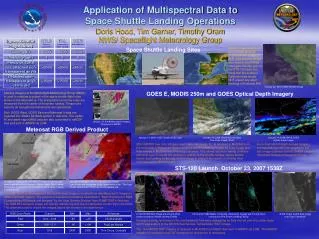
Application of Multispectral Data to Space Shuttle Landing Operations Doris Hood, Tim Garner, Timothy Oram NWS/ Spaceflight Meteorology Group. Space Shuttle Landing Sites.

E N D
Application of Multispectral Data to Space Shuttle Landing OperationsDoris Hood, Tim Garner, Timothy OramNWS/ Spaceflight Meteorology Group Space Shuttle Landing Sites MODIS image displayed on the SMG McIDAS overlayed with Edwards AFB runways plot. Image was used to brief NASA managers the day prior to the STS-120 launch to show that the southern California fires would NOT impact any abort landings at Edwards AFB. October 22, 2007 2055Z MODIS Image GOES E, MODIS 250m and GOES Optical Depth Imagery Satellite imagery at the Spaceflight Meteorology Group (SMG) is used to evaluate a subset of the space shuttle flight rules shown in the table above. The precipitation proximity rules are measured from the center of the prime runway. These rules assume all navigational instruments are operational. Both GOES West, GOES East and Meteosat 9 data are ingested into SMG’s McIDAS system in real time. The visible, IR and water vapor MSG data are also converted to netCDF files and sent to AWIPS via LDM. January 15, 2008 Meteosat 9 Imagery Displayed in AWIPS Meteosat RGB Derived Product B B January 14, 2008 1532Z Visible GOES East January 14, 2008 1532Z MODIS 250m True Color Image (Terra) January 14, 2008 1545Z GOES Optical Depth Image Low clouds? 250m MODIS true color imagery over Cape Canaveral, FL, is received in McIDAS from the University of Wisconsin Space Science and Engineering Center as a jpg image and then viewed in McIDAS via a Netscape browser. This allows detailed viewing of where and what type of clouds are located in relation to the shuttle runway. Space shuttle launch and landing times vary, so this image is useful if the launch or landing time coincides with a MODIS pass. 4km cloud optical depth derived imagery corresponding to MODIS imagery to the left. Image obtained from the NASA Langley Cloud and Radiation Research Group. Low clouds A A Low clouds STS-120 Launch October 23, 2007 1538Z January 14, 2008 20:45 UTC MSG IR Image (10.8 um) with linear black/white enhancement ( Warm = dark, Cold = white). The area of concern for the TAL landing site at Istres, France, is shown in red. January 14, 2008 20:45 UTC Microphysics Image: Low clouds and fog appear in light green/white color. Thin high clouds appear blue. Thick high clouds appear red. An RGB Nighttime Microphysics Derived Product Image is created from raw Meteosat 9 Images in SMG’s McIDAS system. The product is based on procedures described in “Best Practices for RGB Compositing of Multispectral Imagery” by the User Service Division from EUMETSAT’s Web site.The RGB Microphysics image can quickly identify fog and low clouds below shuttle flight rule limits. The channels used to create the images above are shown in the table below. 0713Z MODIS SST Image with 20 and 30nm circles around the Shuttle Landing Facility 1301Z and 1538Z Radar Composite Reflectivity Images with 20 and 30nm circle around the Shuttle Landing Facility 1532Z Visible GOES East image over Cape Canaveral Showers moving northwest in the southeasterly flow were dissipating as they moved over the colder water which was evident in the MODIS Sea Surface Temperature (SST) image. The 1km MODIS SST imagery is received in McIDAS from SSEC then sent to AWIPS via LDM. The MODIS imagery is received in netCDF format so no conversion is necessary.