Download
1 / 23
230 likes | 372 Vues
An Observing System for Canadian Arctic Ice Caps. Martin Sharp Earth and Atmospheric Sciences University of Alberta. Queen Elizabeth Islands ~110,000 km 2 ice. Grant. Agassiz. Muller. Likely to respond more quickly

E N D
An Observing System for Canadian Arctic Ice Caps Martin Sharp Earth and Atmospheric Sciences University of Alberta
Queen Elizabeth Islands ~110,000 km2 ice Grant Agassiz Muller Likely to respond more quickly than Greenland ice sheet (response times on order of centuries to a millennium) Prince of Wales Steacie Sydkap Manson Behaviour very poorly known Devon
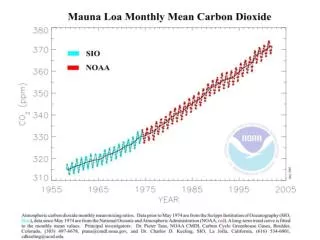
The Arctic climate is changing and is expected to continue to change Mean Annual Air Temperature 2060-2089 c.f. 1961-1990 Source: Polar Research Group, U.Illinois Arctic Annual Temperature Trends 1954-2003 Source: J.Walsh
The Problem • Is the area and volume of Canada’s Arctic glaciers and ice caps responding to these climate changes - and how rapidly ? • What is the contribution of these changes to global sea level? • How important are the different mass loss processes - surface melt and iceberg calving?
An Observing System • Gradual development since 1994 • Modeled on PARCA - mix of remote sensing (airborne & satellite), in situ observations and modeling • Done with multiple increments of short term funding and few people • Key differences from Greenland - scale of ice masses, max elevations (minimal dry snow zone), extensive surface melt, more complex topography
What do we need to know? • Ice extent - multiple epochs • Surface elevation - multiple epochs • Ice thickness and bed topography • Surface velocity (and its temporal variability) • Surface mass balance (including inter-annual variability) • Iceberg calving flux
Ice Extent • Data sources: 1:60k aerial photography (1959/60) and derived 1:250k NTS maps (digital); Landsat7 ETM+ and ASTER (1999-2004) • Alternatives: DISP (1960’s), MODIS, LandSat • Accuracy (line placement due to digitizing, snow, cloud, shadow masking): AP 5-75m; ETM+ (15-120m) • Problems: • N. Ellesmere not covered in recent period • ice outline errors in NTS maps • limited ground control for AP • lack of knowledge of short term variability in calving front positions
The Whole Picture * 1960-1993 only
Surface Elevation (1) • Data sources: • CDED (based on 1:250k NTS sheets and 1959/60 AP); • 1995 & 2000 airborne data (Abdalati, Dowdeswell); • GLAS (post 2003) • Alternatives: kinematic GPS from traverses, InSAR, ASTER • Vertical Accuracy: • CDED - +/-20-50m • Abdalati (ATM) < 0.1m • Dowdeswell (radar terrain clearance and aircraft GPS) +/- 7m • GLAS <0.15m • InSAR 30-40m
Surface Elevation (2) • Issues: • Poor quality of 1959/60 data due to limited ground control and poor contrast above snowline • limited airborne coverage (ATM often misses major outlet glaciers) • spacing of GLAS orbits and limited # of crossing points per ice cap (esp. in S) • InSAR DEMs pick up subtle detail but have poor absolute accuracy • only possible to detect large dynamically driven changes • Needs: improved ground control to redo photogrammetry (potential accuracy +/- 5m) and improve absolute accuracy of InSAR DEMs; more extensive ATM coverage
IceSat Orbits Oct/Nov 2003 Devon Ice Cap CDED - GLAS 2003 NB Only 16 orbit crossing points
Ice Thickness and Bed Topography • Data Sources:Dowdeswell (2000) airborne RES (Devon, Manson, POW, Agassiz) • Alternatives: Older data(Robin, Clarke, Koerner); limited U.Kansas data (1995); flow model inversion • Accuracy: ~ 8m at crossing points • Issues: • No recent coverage forAxel, N.Ellesmere, Sydkap, smaller ice masses • Limited to along flow line on outlet glaciers • Only Devon has dense (10km) grid
Surface Velocity • Data sources: ERS 1/2, RadarSat (InSAR/speckle tracking); Landsat 7 ETM+, ASTER, AP (feature tracking/IMCORR) • Alternatives: balance velocities, static GPS, optical surveying • Accuracy: InSAR - < 3 m/yr in interior regions, < 10% on outlets; Speckle tracking - <10% (but limited validation data); ImCorr - ~ 1 pixel rectification error • Issues: • InSAR - accuracy of external DEMs (CDED) • poor coherence (time period between images, high outlet velocities) • lack of ascending and descending orbit coverage(need to project look-direction velocities) • seasonal variability unknown due to lack of summer coverage • lack of time series • lack of data for balance velocity calculations
Surface Velocities from Interferometry and Speckle Tracking Balance Velocities Devon Ice Cap Flow Field
Surface Mass Balance • Approach: combine ice core analyses and modelling • Problems: • upscaling/downscaling climate input data (ppt/temp) • lack of on-ice temperature data • poor knowledge of accumulation rate fields • lack of validation data for models • Issues: Coarse resolution of passive microwave data limits use for melt detection and accumulation measurement on ice caps (lack of dry snow zone is also problematic for accumulation measurement) • Possibilities:QuikScat for facies mapping, melt detection and possibly melt intensity measurement (critical as inter-annual MB variability is mainly due to summer balance variability)
Lapse Rate Issues John Evans Glacier, Ellesmere Island Evolution of surface air temperature field during 2002 melt season
Air temperature versus QuikScat backscatter Station at 1300m, Leffert Glacier, Prince of Wales Icefield, Ellesmere Island
2001 Warm year 2002 Cold Year Lapse rate implications?
Iceberg Calving Flux • Approach: compute from surface velocity and ice thickness at grounding line • Problems: • poor InSAR coherence due to fast flow near grounding lines • patchy data from ImCorr/feature tracking • poor knowledge of temporal variability in velocity • lack of cross-glacier thickness data near grounding line • floating tongues not well known (bottom melt issue)
Primary Needs (1) • Improved ground control for topographic mapping • Continued high resolution visible imagery for extent (Quickbird/Ikonos acquisition?) • High accuracy surface topography for inversion modelling, balance velocities, volume-area scaling • New thickness datasets, especially for Axel Heiberg and N.Ellesmere, and across outlet glacier grounding lines • Targeted interferometry mission plus year-round GPS measurements on outlet glaciers • Identify grounding lines and floating tongues
Primary Needs (2) • Extended net accumulation dataset from shallow ice cores • compute balance velocity fields • develop climatology • understand patterns of inter-annual variability • Explore potential of RCMs/GCMs for accumulation simulation • Extend air temperature and summer melt measurements • ground truth active microwave data • understand lapse rate variability • model validation • Continued collection of high resolution active microwave data