Download
1 / 14
180 likes | 661 Vues
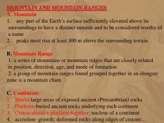
Continental Crust and Mountain Belts. Continents are composed of two basic types of terrain Cratons , where there hasn't been significant structural deformation lately

E N D
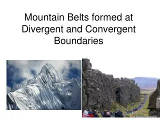
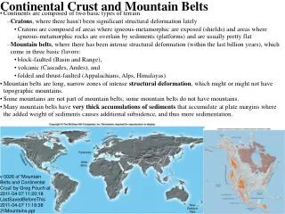
Continental Crust and Mountain Belts • Continents are composed of two basic types of terrain • Cratons, where there hasn't been significant structural deformation lately • Cratons are composed of areas where igneous-metamorphic are exposed (shields) and areas where igneous-metamorphic rocks are overlain by sediments (platforms) and are usually pretty flat • Mountain belts, where there has been intense structural deformation (within the last billion years), which come in three basic flavors: • block-faulted (Basin and Range), • volcanic (Cascades, Andes), and • folded and thrust-faulted (Appalachians, Alps, Himalayas). • Mountain belts are long, narrow zones of intense structural deformation, which might or might not have topographic mountains. • Some mountains are not part of mountain belts; some mountain belts do not have mountains. • Many mountain belts have very thick accumulations of sediments that accumulate at plate margins where the added weight of sediments causes additional subsidence, and thus more sedimentation. v 0026 of 'Mountain Belts and Continental Crust' by Greg Pouch at 2011-04-07 11:20:18 LastSavedBeforeThis 2011-04-07 11:18:38 21Mountains.ppt
Continental Crust and Mountain Belts 3 Cratons 4 Cratons > Shield and Basement 5 Cratons > Shields > Archean 6 Mountain belts > Overview 7 Mountain belts > Extensional 8 Mountain belts > Volcanic 9 Mountain belts > Compressional 10 Map of North America 11 The Wilson Cycle 12 Accreted Terrains 13 Origin of Continents 15 Cratons (single, crowded slide) 16 Mountain belts (single, crowded slide)
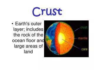
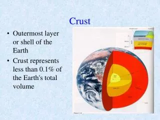
Cratons Cratons (Normal continental crust) Most land area has not undergone significant structural deformation in over a billion years and consists of intensely deformed igneous-metamorphic complex exposed at the surface (shields) or flat sediments overlying intensely deformed igneous metamorphic complex (sedimentary platforms) in which case we call the underlying igneous-metamorphic complex basement. • Cratons are the combination of shields and platforms. • Vast majority of continental area is cratons, that are more or less in isostatic equilibrium. • Deformation and igneous activity might occur at the edges, and there can be igneous activity at hotspots. • Usually, flat or gently rolling. • Opposite of mountains, and part of what gets deformed in mountain building. • In this map, everything in pink and gray is cratons (pink is shield, gray is platform) and brown is mountain belts.
Cratons > Shield and Basement Most crustal rocks are igneous and metamorphic, and there might be a thin veneer of sediments on top. When the igneous-metamorphic rocks in a craton are exposed, we call it a shield (in profile, it's high in the middle and slopes away from center, like ancient Greek or Roman shield). When the igneous-metamorphic rocks are overlain by sediments, we call the underlying igneous-metamorphic rocks basement or basement complex, but they're the 'same' thing (like coastal plain and continental shelf), and if the all the sediments erode from platform area, it goes back to being a shield. The book's cross-section of a continental interior is wrong. There are not a few discrete, huge batholiths embedded in a sea of metamorphic rocks. There are a large number of greenstone belts and granite-gneiss terrains in Archean areas, and younger deformation zones that are transitional from Archean-style to modern-style mountain belts. • Basement complex occurs in provinces (100s-1000s km) of similar structural style and grain, with similar ages for deformation. Archean deformation does not look like a modern fold belt (dominated more by elevator tectonics than plate tectonics). Most younger complexes show at least relict dates going to 2.5 Ga, and you can often trace very old features into and through younger mountain belts, like greenstone belts in the Grenville Province. • Platforms are stable areas, underlain by basement complex, overlain by flat-lying sediments deposited in shallow seas, sedimentary basins, or passive margins. Sediments are usually very mature. • Sediment thicknesses on platform are often less than 1000 m. In basins, this may go to 3000 m.
Cratons > Shields > Archean • Greenstone belts are huge syncline-like downwarps of thick sequences of supra-crustal rocks (sediments and volcanics). The volcanics are bi-modal (ultra-basic to basic and rhyolites, but no andesite). The sediments are dominated by turbidite greywacke, shale, and immature conglomerates. These are very important economically, so well studied • Greenstone belts are intensely deformed (folded, faulted, very low-grade metamorphism) and the deformation occurred at the same time as the deposition/eruption. Field relationships are frustratingly complex, but they seem to have extruded onto continental crust, and are intruded by continental granitoids. • A plausible explanation: Start with continental crust above. Ultra-mafic volcanoes erupt (due to mantle plume, asteroid impact, rifting, … your pick). Sediments are eroded from the volcano chain. Added weight causes sagging of the thin, hot lithosphere, leading to partial melting and eruption of rhyolites and intrusion of granites, along with the deformation. • Typical size would be 6-20 km thick sediments, 50 km wide, 500 km long. • Granite-gneiss terrains consist of small granite plutons, gneisses, and very high grade metamorphic rocks, lots of migmatites and veins. The whole configuration suggests that these were not intruded in a single episode or short series (like modern batholiths), but that the rocks kept getting re-mobilized. The sharp changes in metamorphic grade might be due to strong influences of water (on effective pressure and temperature), or that these are more heavily faulted and deformed than we think. They might represent lower continental crust under modern conditions, or continental crust subject to more vertical motions and higher geothermal gradients.
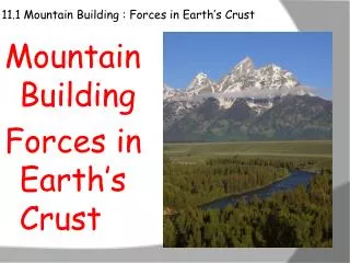
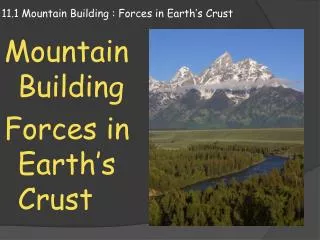
Mountain belts > Overview • Mountain belts long, narrow zones of intense structural deformation, which might or might not have mountains. (Some mountains are not part of mountain belts; some mountain belts do not have mountains, but mountain belts always have uplift—which might or might not be faster than erosion can wear them down—and consequently shed sediments.) • Mountain belts come in three basic flavors: • block-faulted (Basin and Range), [extensional] • volcanic (Cascades, Andes), [volcanic, and largely neutral] • folded and thrust-faulted (Appalachians, Alps, Himalayas). [compressional] • Many mountain belts have very thick accumulations of sediments that accumulate at plate margins where the added weight of sediments causes additional subsidence, and thus more sedimentation.
Mountain belts > Extensional • Block faulted (Basin and Range NV-AZ-UT-NM, East African Rift Valley) This can happen to/in almost any geologic setting, but is most classically associated with continental rifting. • Parallel normal faults separate the landscape into downdropped grabens (basins) and uplifted horsts (ranges). • Thick sediments, some immature and often including evaporites and limestones, accumulate in the grabens. • Adjoining faults may not have the same throw, resulting in tilting of the blocks. • Usually, there are very early basalts, followed by rhyolites once the lower crust gets heated enough to generate granitic melt, then followed by no igneous activity. • Structures are generally extensional (normal faults). • Shallow or no earthquakes. • Little or no metamorphism. • Gravity indicates thin crust. • Origin of passive margins and some coastal mountains
Mountain belts > Volcanic • Volcanic chain (Andes, Indonesia, Cascades) • Sierra Nevada is root of a volcano belt. • Partial melting of subducting oceanic crust gives rise to andesitic volcanoes. • Central part is completely dominated by volcanism and deeper plutons. • The weight of the volcanoes and resulting immature sediments cause downwarping of adjacent crust and thick accumulation of sediments, with thrust faulting and folding. • Metamorphism consistent with intrusions and eruptions: very steep geotherm. • Structurally neutral, deep earthquakes (some shallow quakes as well), minor secondary extensional features. • Active margin
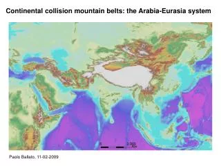
Mountain belts > Compressional • Collision Zone (Alps, Himalayas, Appalachians) • Deformation increases towards center-line, which may be fairly simple crystalline terrain (simple batholiths of uniform age, and simple metamorphic grades decreasing from center, like Maine) • Outer parts are thick sequences of sediments and volcanics, thrust faulted and folded (like Pennsylvania) • Deformation dies out as you move outward. • Sediments may accumulate in basins flanking the mountains. • Might have topographic mountains or might not (Himalayas vs. Tibet). Erosion and isostatic rebound can cause uplift of peaks. • Structurally compressive, with minor, secondary extensional features. • Shallow earthquakes. • Simple metamorphism and intrusions. • Geotherm indicates fairly gentle increase of temperature with depth. • Granitic intrusions, minor rhyolite volcanics. • Gravity indicates doubling of crustal thickness.
The Wilson Cycle: The Official Plate Tectonics Explanation of Origin of Mountains and Almost Everything Else • Rifting of continent gives block-faulted mountains. One basin may eventually become an ocean. • The ocean gets old, cold and starts to subduct. • Subduction of oceanic crust yields andesite by partial melting, causing island arcs or volcano chains. • Continent-Arc collisions and, finally, a Continent-Continent collision occur as arcs and the continent are carried to the subduction zone by the subsiding ocean. This results in compressional events (orogenies), thickening of continental crust followed by erosion and isostatic rebounds. • Secondary tension on outside of bends • Secondary block faulting due to isostasy • Delamination of lower part of lithosphere (cold mantle) resulting in sudden heating of crust, possibly with igneous activity.
Accreted Terrains • Accreted/suspect/exotic terrains: basic gist is that fragments of plates get separated and collide. • There have to be segments of plates in collision zones (like the leading edge) that get displaced and would be exotic terranes. Geometrically, this has to be true sometimes. • I don't see many "micro-continents" on a present day map • I've seen too many features that continue across terrains and pre-date their supposed incorporation to believe in this as much as some people do. • It seems very suspicious that everything that is hard to explain is swept away with a deus ex machina explanation.
Origin of Continents Plate tectonics explains the origin of oceans and oceanic features quite well. It kind of explains some deformation of the edges of continents. It fails to explain many features of continental interiors. The following is a plausible, but not necessarily widely accepted, explanation. • In the beginning, ultra-mafic rocks (mantle) partially melt to give mafic rocks, which get partially melted to produce andesitic rocks, which partially melt to produce granitic rocks (continental crust). • Size of an area that needs to stay in isostatic equilibrium increases with time as the planet has cooled and the lithosphere has thickened. Early on, 'isostatic size' was very small, now it is around 100km. (Think of ice thickening on a pond: with thin ice, any weight causes warping, as the ice gets thicker, larger objects can be placed on the ice and are supported by the strength of the ice) • Pre-Archean 4.6-3.8 Ga Planet coalesces homogeneous and cold from the solar nebula. Iron catastrophe and near-melting of mantle, eruption of basaltic crust, vertical subsidence (elevator tectonics) and partial melting moving rocks down Bowen's reaction series, leading to origin of continental crust. Size of area that needs to stay in isostatic equilibrium very small, maybe 5 or 10km. • Archean 3.8-2.5Ga Greenstone belts (vertically subsiding elevator tectonics of volcanic arcs or hotspot tracks). Possible plate-style extrusion and subduction of oceans, probable drifting of continents carrying greenstone belts. High geotherm makes granite unstable at a shallower depth, so much more generation of partial melts. Size of area that needs to stay in isostatic equilibrium small, maybe 50km. • End of the Archean No more ultra-mafic volcanoes. Granitic rocks go from being granite-like (quartz and sodic plag) to true granites (quartz, K-spar, and sodic plag). If the mantle underwent some big ex-solution event, that could explain how a lot of potassium suddenly appears in the crust, and the degree of partial melting in the mantle suddenly drops. • Transition to modern plate tectonics ~2.5 to 1.2 Ga • Plate tectonics 1.2Ga-present Modern style plate tectonics. Size of area that stays in isostatic equilibrium reaches point where horizontal plate deformation dominates. North America separates from Europe at 1.2 Ga, collides, separates again around 0.6 Ga (collides around 0.4Ga), separates around 0.2Ga… Tendency for plates to break apart along old sutures, and odd tendency to collide with the same plate they separated from. (Start seeing blueschist metamorphism (low T, high P). Thrust faults. Granitic intrusions are fairly simple.)
Continents and Mountain Belts • Continents are composed of cratons and narrow mountain belts. • Cratons include shields where basement is exposed and platforms where it is covered by sediments. Old (Archean) basement has greenstone belts and granite-gneiss terranes but lacks the simple metamorphic zones and extensive related intrusions found in modern mountain belts. • 'Modern' mountain belts come in three flavors • Extensional (rifting phase of Wilson cycle) • Volcanic (subduction phase of Wilson cycle) • Compressional (continental collision phase of Wilson cycle) • Continents might grow by accreting volcanic mountain belts, or this might just be re-working of old continental crust. • Collision zones are not as regular as simple diagrams, and involve at least some strike-slip motion giving rise to exotic terranes.