Addressing Climate Extremes in Infrastructure Planning and Resource Management
This presentation summary highlights the essential climate and weather extremes that impact resource management and policymaking, focusing on parameters like intense precipitation, temperature variability, hurricanes, and sea-level rise. It identifies information gaps in real-world applications and emphasizes the importance of accurate climate models in conveying risks. The discussion also addresses the role of technology in flood control planning and the need for a new paradigm in understanding climate-related risks. Ultimately, it calls for a collaborative effort to develop a comprehensive global hazards database to better inform decision-makers.

Addressing Climate Extremes in Infrastructure Planning and Resource Management
E N D
Presentation Transcript
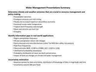
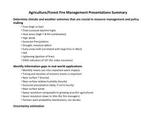
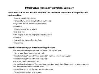
Infrastructure Planning Presentations Summary Determine climate and weather extremes that are crucial in resource management and policy making Intense precipitation events Temperature, Tmax, Tmin, Heat waves, Freezes High wind events, low wind speed events Humidity Hurricanes and storm surges Sea level rise PBL height, inversions, high pressure stagnation Drought Snowfall, Ice Storms, Freezing Rain Lightening Identify information gaps in real‐world applications Number of intense precipitation events (>.5 in/day) per year Storm surge flood recurrence intervals Number of days/year with Tmax above 90F; number of heat waves/year Number of days/year with Tmin below 32F Increased flood recurrence rate Probability distribution of floods per year based on prediction of large-scale circulation patterns and interactions with local land surface Land-falling hurricane frequencies and intensities Targeting information to engineers
Infrastructure Planning Panel Discussion Summary How can user expectations on what is available from models be managed? Modeling community needs to understand and convey limitations of current climate simulations and how to address uncertainties. Depends on phenomena being considered. Models do good job of heat, cold, droughts, based on large-scale patterns (e.g., ENSO, jet streams) for which the GCMs perform well. However, precipitation events and floods are not well done. Recognize that unfortunately some will misuse information How to address expectation that biases will remain the same from the historic period? Haven’t seen demonstration that it fails. Can test using observation records since 1950 and apply bias correction for 1950-1980 and 1980-2010 periods. Still lack confidence when extrapolating outside the boundary of the model. Emphasize instead putting realistic representation of physical processes in model. Focus on improving parameterizations. Importance of getting boundary forcing correct. Appropriate data assimilation systems are addressing this issue. Fully appreciate urgency in providing information.Desire not to be satisfied with current performance of GCMs and RCMs.
Infrastructure Planning Panel Discussion Summary Can you ellaborate on participating in the Global Flood Inititative? Recognize that institutions around world are mired in set strategies. Want to bring together people interested in solving problems. Policy makers want to know if there is a technology solution available to them. If we can find such a tech-based solution, then possible to leapfrog institutional impediments. Flood control infrastructure impacts/influence not well quantified. Sense is that major flooding events are due to a number of occurrences and persistence of successive events. Composites showed huge floods with accumulation over time. Works better for extreme cases, because signal is stronger Conceptually looking at mechanisms. Seeing Rossby wave transport from equatorial western Pacific Can have massive surface low, but need accompanying upper level divergence In organized landscapes and deforestation there are local effects. At larger basin scales, not demonstrated.
Infrastructure Planning Panel Discussion Summary What information is needed for reinsurance? Model genesis of storm from initiation to landfall to decay Determining influence of natural variability-related short term vs. climate change Insurance is inherently a backward looking enterprise. What timescales do insurers consider in terms of sea level rise? For US, don’t think about it much. As sea level rises they will raise rates consistently, adjusting on annual basis. How much protection is it providing when rates are just going up? Can you insure your way out of these problems? In CA, Governors adaptation panel addressed house development on beachfront. If insurance could be priced to reflect increased risk, then decisions to build could be influenced. Difficult, if not impossible, to charge premiums based on forecast changes in risk. Should we have a new paradigm in addressing climate extremes in a changing climate? Need community effort to develop global hazards database. If can put information into risk model (e.g. 2C warmer and impacts on energy use) then would be more useful to policy makers. There are sophisticated reinsurers. When frame problem as risk assessment, then changes the dynamics a lot. Allows this community to engage decision makers more effectively. Like to push paradigm that we in US think we have addressed risk; In developing world have different measure of risk. Need to develop consistent approach globally.