DVB-S2 Transmission
GOES-R User Data Types and Structures Andrew Royle GOES-R Ground Segment Project NASA Goddard Space Flight Center Andrew.W.Royle@nasa.gov Presentation #IN41B- 1498. GOES Rebroadcast (GRB) provides near real-time data to users via satellite downlink from GOES-R Series spacecraft.

DVB-S2 Transmission
E N D
Presentation Transcript
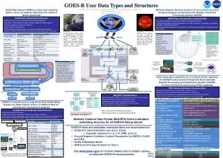
GOES-R User Data Types and Structures Andrew Royle GOES-R Ground Segment Project NASA Goddard Space Flight Center Andrew.W.Royle@nasa.gov Presentation #IN41B-1498 GOES Rebroadcast (GRB) provides near real-time data to users via satellite downlink from GOES-R Series spacecraft National Weather Service receives L2+ sectorized cloud and moisture imagery via the Advanced Weather Interactive Processing System (AWIPS) GOES Rebroadcast Characteristics • 31Mbps of Level 1b (L1b) data from all GOES-R instruments • New types of data (lightning, space weather, additional imager bands) • Increased spatial and temporal resolution • Data formatted into NetCDF4 • GRB Information Packets sent every 5 minutes and include schedule, operational status, INR, and other information relevant to the user community AWIPS Data and Interface Characteristics • Low latency data delivered directly to NWS via dedicated interface • Configurable based on selected parameters (bit depth, projection, geographic coordinates, periodicity, and spatial resolution) • Data transferred in tiles which are individual netCDF4 files that together comprise the entire end product Credit: NASA Credit: NASA Current GOES satellites switch to geographically constrained modes of operation to cover storms such as 2012’s Hurricane Sandy. GOES-R Series satellites will be able to provide 1000 x 1000 km images every 30 seconds while maintaining routine scanning schedules GOES-R Series satellites will carry a series of advanced space weather instruments capable of generating solar imagery such as the above, from NASA’s Solar Dynamic Observatory (SDO) GOES-R GS Product Distribution CDR Wallops Command and Data Acquisition Station, Wallops VA OC-3 (155 Mbps) per line AWIPS Network Control Facility, Silver Spring MD DVB-S2 Transmission CADU Stream Generation AOS Space Packets CCSDS Space Packets Remote Backup, Fairmont WV AWIPS Backup Network Control Facility, Fairmont, WV Distributed to NWS field offices via AWIPS Authorized users subscribe to or conduct ad hoc searches for GOES-R end products through the Environmental Satellite Processing and Distribution System (ESPDS) Product Distribution and Access (PDA) capability GRB Data GRB Hdr CCSDS Hdr GRB Data GRB Hdr CCSDS Hdr GRB Data GRB Hdr CCSDS Hdr GRB Block (compressed) PDA Data and Interface Characteristics • Subscription and ad hoc query service available to registered users • Provides most recent seven days of data for ad hoc queries and retrieval • Primary distribution pathway for L2+ end-products other than Cloud and Moisture Imagery • Products sent from GOES-R in NetCDF4; PDA has McIDAS translation capability GRB Block (compressed) GRB Block (compressed) GRB Block (compressed) GRB Block (compressed) GRB Block (compressed) Decompression GLM, SEISS, SUVI, MAG, EXIS data (each separately delivered) L1b ABI Block L1b ABI Block L1b ABI Block NetCDF4 Characteristics • Machine-independent format for representing science data in an array structure • Self-describing format enabling user-defined data types • Appendable to include metadata alongside science data • Built-in zlib algorithm enables compression transparent to user • NetCDF4 enables use of HDF5 data format NetCDF Files NetCDF Files L1b and L2+ GOES-R Products available through PDA (and CLASS) PDA Interface Characteristics • Low latency distribution for all GOES-R End Products • Subscription and ad hoc query capability • Application Programming Interface for users • Limited to authorized NOAA users • Data in NetCDF format; translation capability to McIDAS NOAA’S Comprehensive Large Array-Data Stewardship System (CLASS) enables archive of GOES-R data for retrieval and retrospective analysis CLASS Data and Interface Characteristics • Long-term archive for GOES-R data • Unique source of certain GOES-R data types (L0 data, algorithm packages) • Data is sent to CLASS Receipt Nodes at each GOES-R facility and is then ingested and maintained by NOAA’s National Climatic Data Center (NCDC) and National Geophysical Data Center (NGDC) More information on NetCDF4 available at: http://www.unidata.ucar.edu/software/netcdf/ Unidata NetCDF4 Data Model Network Common Data Format (NetCDF4) forms a standard underlying structure for all GOES-R data products National Geophysical Data Center, Boulder CO National Climatic Data Center, Asheville NC NOAA Satellite Operations Facility, Suitland MD # • GOES-R data and metadata characteristics are documented in: • GOES-R Product Definition and Users’ Guide • Separate volumes for L0, L1b, GRB, and L2+ • Ground Segment Interface Control Documents for AWIPS, CLASS, and PDA • GOES-R Metadata Model • GRB Downlink Specification for Users • See www.goes-r.gov for further details and to obtain copies of selected GOES-R documentation CLASS Nodes Wallops Command and Data Acquisition Station, Wallops VA L2+ Products (other than KPP and GLM) CLASS Receipt Nodes (at each facility) L0, L1b, L2+ KPP & GLM products GRB Info Pkts Inst. Cal. Data NOAA Satellite Operations Facility, Suitland MD # Also distributed from PDA in FITS format Remote Backup, Fairmont WV Colors correspond to GOES-R instruments Data is sent from GOES-R to CLASS Receipt Nodes at each GS facility