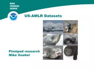
US AMLR datasets
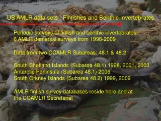
US AMLR datasets. Ship-based oceanographic, biological and acoustic data. Drew Shindell, NASA-GISS. The ship-based program collects a variety of data. Ship-based Program Duration Quant. krill net tows (species, stage, maturity; >3000) 1993 - present*

US AMLR datasets
E N D
Presentation Transcript
US AMLR datasets Ship-based oceanographic, biological and acoustic data
Drew Shindell, NASA-GISS The ship-based program collects a variety of data • Ship-based Program Duration • Quant. krill net tows (species, stage, maturity; >3000) 1993 - present* • Water properties (CTD; > 3000) 1990 - present • XBT/ Drifter deployments (500 XBTs, >100 drifters) 2005 - present • Underway met. and ocean. data (>50 000 km) 1990 - present • Acoustics (EK-500; 2 frequencies) 1990 - 2000 • Acoustics (EK-60; 4 frequencies) 2000 - present • Chl-a/ species/ size/ nutrients (>10,000) 1990 - present • Bird/mammal observations (30 000 km) 2000 - present • Occasional studies • Iron / trace metals (3 years; >300 samples) 2006-2008 • Ancillary and special acoustic surveys 2004-2006, 2008 • Satellite data validation (SIO/NASA partners; 17/47 SO datasets) 1997 - 2008 • *Partner programs extend the data farther into past
Scotia Sea Drake Passage ACC South Shetland Islands Latitude Bransfield Strait Antarctic Peninsula Weddell Sea Longitude AMLR Survey Grid and Predator Field Camps • Elephant Island area • Historical fishery • Long term sampling • Seal Island field camp
AMLR Survey Grid and Predator Field Camps Scotia Sea Drake Passage • Expanded in 1997 • Reflect change to monitoring • Close to population centers • New Camp at Cape Shirreff • Copacabana ACC South Shetland Islands Latitude Bransfield Strait Antarctic Peninsula Weddell Sea Longitude
AMLR Survey Grid and Predator Field Camps Scotia Sea Drake Passage ACC • Expansion south (2007, 2008) as ice allows. • Do we expand to determine distribution and abundance of krill and other species in other areas South Shetland Islands Latitude Bransfield Strait ? Antarctic Peninsula Weddell Sea Longitude
Time series of krill and plankton Krill Salp Ice
At-sea avian distributions and krill hotspots Krill Distribution Cape Petrel
At-sea mammal observations – coupled with krill net tow data and demography 13-34 mm 45-65 mm Humpback Fin
2.5 30 25 2 20 -3 1.5 15 Chl-a (mg m ) UML Int. Chl-a (mg m ) 1 10 -2 0.5 5 0 0 88 90 92 94 96 98 00 02 04 06 08 Year Oceanographic data to examine bottom up processes Integrated and UML chl-a highly correlated Significant interannual variability 0.3 – 2.0 mg m-3 Low periods in 1992 and 1998 associated with El Nino
70 3 60 2.5 50 2 40 UML depth (m) 1.5 30 UML temperature ( C) 1 20 0.5 10 o 0 0 1985 1990 1995 2000 2005 2010 Year Chl-a (mg m ) 34.2 -3 34.1 UML salinity (psu) 34 33.9 1985 1990 1995 2000 2005 2010 Year 2.5 2006 2 1995 1.5 1 0.5 0 0 0.5 1 1.5 2 2.5 3 o UML temperature ( C) Linking physical environment to productivity • Integrated physical and biological data include • Upper mixed layer (UML) • temperature • depth • salinity • To examine: • Productivity (chl-a) and variability in physical environment
Spatially resolved for satellite comparisons of chl-a and primary production • AMLR sampling recovers spatial structure • Satellite ocean-color data lack other variables necessary to understand why productivity • Physical data can be used to validate models of production in IPCC Class models • US AMLR cruises represent at least 17 of 47 Southern ocean datasets (NASA Grants to SIO) 10 yr SeaWiFs mean 10 yr AMLR average
Database A comprehensive, quality-controlled at-sea database (1990 to present) Data input forms for each database component At-sea bird and mammal track-line, acoustic and sea surface data are in a database Oceanographic and net based data associated with trawl data have been incorporated Quality-control and quality-assurance procedures are being developed First reanalysis and reprocessing of CTD is being conducted
Unique attributes Longest (with historical partner data) plankton time series Largest and longest quantitative multi-frequency acoustic time series Only comprehensive, integrated and repetitive at-sea bird and mammal observation program Longest continuous oceanographic (CTD) and chl-a time-series in the Scotia Sea Limitations No winter data, no shoulder season coverage Opportunities Gliders, AUVs for hydrographic and plankton data Modeling for integration and synthesis