NAVO Multibeam Workshop
670 likes | 1.06k Vues
NAVO Multibeam Workshop. Gulfport, MS. IXSEA Ltd Edinburgh. IXSEA bv Amsterdam. IXSEA SAS Brest. IXSEA SAS Marly. IXSEA SAS Carqueiranne. Organization. iXSea, Inc – Boston, MA. iXSea, Inc – Charleston, SC. Organization. Development of USBL positioning.

NAVO Multibeam Workshop
E N D
Presentation Transcript
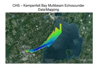
NAVO Multibeam Workshop Gulfport, MS
IXSEA Ltd Edinburgh IXSEA bv Amsterdam IXSEA SAS Brest IXSEA SAS Marly IXSEA SAS Carqueiranne Organization
iXSea, Inc – Boston, MA iXSea, Inc – Charleston, SC Organization
Development of USBL positioning 1st series of Acoustics Releases & Transponders by OCEANO Instruments 7xx series : AR701AE & TT701 6xx series MT8xx, TT8xx & RM8xx 8xx series Posidonia 1970 1997 1985 1994 1999 2001 2002 1978 1987 2000 1998 2003 Merger & creation of IXSEA OCEANO iXSea, Inc Development of FOG technology starts PHOTONETICS OCTANS Creation of IXSEA PHINS Brief history of the company
Products & technologies • IXSEA is a world leader in three technologies: • Fiber Optic Gyroscopes (FOG) • OCTANS gyrocompass & motion sensor • PHINS Inertial Navigation System • Underwater Acoustics • Acoustic Releases • POSIDONIA USBL • Magnetic sensors • MAGIS
PRODUCTS • PHINS • a navigation system (INS) providing data on the attitude (true heading, roll, pitch) and position (latitude, longitude, altitude) of any mobile object. • OCTANS • a strap-down IMU that contains three fiber optic gyros in the 0.05°/hour class, three milli-g acelerometers, and a real-time DSP computer. • POSIDONIA • USBL Acoustic Positioning System using an innovative combination of Chirp & FM modulation techniques. • GAPS • a unique Global Acoustic Positioning System based on iXSea’s mastery of INS and acoustic Chirp modulation techniques.
PHINS: Turnkey for Marine Applications • Marine Positioning System • PHINS is an Inertial Navigation System specially designed to provide surface vessels with: • Position • Heading • Heave • Speed • Attitude • An ideal tool for survey and positioning • A cost-effective concept • Open to multiple sensors
PHINS is not only the lightest and most compact Inertial Navigation System designed for Marine vehicles but also the most effective system. Multibeam Hydrographic Survey Dynamic Positioning • Consuming little power and ready to integrate, it is the ideal solution for multibeam hydrographic surveys and Dynamic Positioning systems.
Meters 5 4 3 2 1 0 PHINS: Position errors Vs GPS Outage Duration 10 20 30 40 50 60 70 80 90 100 110 Time (seconds) PHINS: Plug and Play Positioning for Marine Applications • Robust when GPS drops out • Cost-effective • No drift • Simple • Flexible • Permanent quality control • User-friendly • Compact • Autonomous • High Performance • 0.01° Heading • 0.01° Attitude
OCTANS: Easy Set-Up & Configuration • OCTANS configuration software allows an individual setting of each port and the simultaneous use of up to 5 inputs and 7 outputs. • Serial I/O • • Protocol • Industry standards, • NMEA 0183,binary • • Electrical Level • RS232 or RS422 • • Baud Rates • 600 Bauds to 115 K Bauds • • Bits • Number of stop bits/parity • Analog I/O • Scale factors • Pulses I/O • Scale factors • Output Frequency • 0.001 Hz up to 100 Hz • Internal Update Rate • 300 Hz • Heave Filtering Self Adaptive
OCTANS Operational Assets • No Heave Build-Up:heave stays stable during turns without the aid of external sensors • Easy Integration:OCTANS interfaces all multibeam • and single beam echo sounders, ADCPs, and survey packages OCTANS emulates all existing motion sensors and gyrocompasses • Monitoring of up to 3 points (lever arms / angular offsets) • No external control unit
OCTANS SUBSEA 1000 OCTANS SUBSEA 1000Integrated in Benthos C3D Towfish
POSIDONIA: Sets New USBL Standards CHIRP : Unique Advanced Digital Signal Processing
POSIDONIA: Able to Track… • FREE TRACKING MODE • Positioning of ROV/AUV’s • Positioning of mooring lines • Coring • TOWFISH MODE • Survey • Towfish Tracking
POSIDONIA: System Performance The global POSIDONIA 6000 performance is better than 0.3% of the range up to 6,000 m depth in the 60° cone below the ship (e.g. less than 9 m at 3,000 m range).
POSIDONIA: System Overview ACOUSTIC ARRAY ACOUSTIC PROCESSING UNIT NAVIGATION OPERATOR INTERFACE «ABYSS» EXPENDABLE OR RECOVERABLE TRANSPONDER
GAPS: Merging of Inertial &Underwater Acoustic Technologies • Precise positioning of several underwater vehicles, • Very high-accuracy attitude and heading data of the GAPS module support, • High update rate surface vessel positioning, • Robust treatment of GPS drop-out and insensitivity to GPS jumps. • Compact & portable • Plug and play • Calibration-free (even when the system is moved from ship to ship) • Outstanding price ratio for this portable high-end performance system.
GAPS: The Ultimate System Installation Portability UNDERWATER STATION BUOY INSTALLATION SHIP MOUNTED SMALL BOAT OR ZODIAC
GAPS: A Wide Set of Applications SURFACE POSITIONING AND ATTITUDE CONTROL SUBSEA POSITIONING • Dynamic Positioning systems (primary or back-up) • Reference for multibeam echo sounders and ADCPs • Navigation • AUV, ROV, tow fish and pig tracking positioning • Offshore construction and installation • Research and salvage projects • Mooring line positioning • Pipe and cable laying • Site survey projects • Diving work supervision
Components:Display Operator-System Interface Software (Supervision)
Components:Display Operator-System Interface Software (Supervision)
Components:Display Operator-SystemInterface Software (Navigation)
IMU 90 FOG: Inertial Measurement Unit • Really Solid State Technology • Fiber Optic Gyro Technology • High Performance • Maintenance Free • Very Short Reaction Time • Low Cost of Ownership
PHYSICAL CHARACTERISTICS IMU 90 FOG • Size 280x136x150 mm3 • Weight 4.8 Kg • GYRO PERFORMANCE Dynamic range ± 500 °/s Bias stability at ambient temp 0.005 °/h rms Bias stability over temperature range (-40 °C/+60 °C) 0.05 °/h rms Random walk noise 0.0025 °/√h Scale factor stability over temperature range (-40 °C/+60 °C) 30 ppm rms Angular resolution 0.2 arc sec
MAGIS THE BEST ACHIEVEMENT IN MARINE MAGNETOMETERS
DYNAMIC NUCLEAR POLARISATION • A Technology developed for defence and space applications by the French Commissariat à l’Energie Atomique and licensed to iXSea SAS
3 Water Depth Versions Available • 300m • 1000 m • 6000 m
Magnetometer Specification • Omni-directional Detection Capability • Dynamic Range: Worldwide (23-70 µT) • Resolution: 0.01 nT • High sampling rate (up to 10 Hz) • Sensitivity: .0035 nT/Hz-1/2 @45,000 nT • Sensitivity independent of sampling rate
MAGNETOMETER SENSOR • No blind angle • Shock resistant • High sensitivity • Outputs continuous signal for past sampling rate
Requirement for a Subsea Release Acoustic Release Introduction • To RELEASE a load • By REMOTE CONTROL(usually the surface) • When we want(Timers actuate at a fixed time…) • Nothing visible on the surface • No obstruction to shipping • No surface float to drag the mooring sideways • No diver required • Re-usable… again and again
An ACOUSTIC RELEASE SYSTEM is … • Remote control surface TELECOMMAND unit sending commands through the water • A subsea receiver unit with aRELEASE HOOK
Telecommand TT301B • Telecommand TT301B is compatible with the whole product range. • NEWTT801is also compatible with the whole product range.