Download
1 / 2
20 likes | 163 Vues
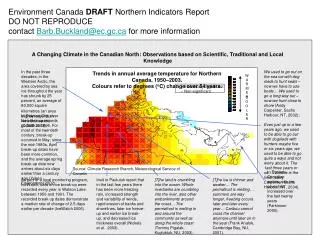
In the past three decades, in the Western Arctic, the area covered by sea ice throughout the year has shrunk by 25 percent, an average of 80,000 square kilometres (an area slightly larger than New Brunswick) (CCME 2003).

E N D
In the past three decades, in the Western Arctic, the area covered by sea ice throughout the year has shrunk by 25 percent, an average of 80,000 square kilometres(an area slightly larger than New Brunswick) (CCME 2003). We used to go out on the sea ice with dog sleds to hunt seals – now we have to use boats… We used to go a long way out – now we hunt close to shore (Andy Carpenter, Sachs Harbour, NT, 2002); Even just up to a few years ago, we used to be able to go out with dogsleds with hunters-maybe five or six years ago, we used to be able to go quite a ways and not worry about it. The 1ast three years or so... 12 miles is the limit. (Larry Carpenter, Sachs Harbour, NT, 2004). • Trends in annual average temperature for Northern Canada, 1950–2003. • Colours refer to degrees (oC) change over 54 years. W A R M E R A Changing Climate in the Canadian North: Observations based on Scientific, Traditional and Local Knowledge x – Statistically Significant – Non-significant C O O L E R In Dawson City, river ice break up records go back to 1896. For most of the twentieth century, break-up occurred in May; since the mid-1980s, April break-up dates have been more common, and the average spring break-up date now arrives about six days earlier than a century ago (Yukon Environment 2002). Source: Climate Research Branch, Meteorological Service of Canada In Eastern Canadian waters, sea ice cover has increased over the last twenty years (Parkinson 2000). As part of a local monitoring program, IceWatch, data on ice break-up were recorded every year in Watson Lake between 1950 and 1991. The recorded break-up dates demonstrate a median rate of change of 2.5 days earlier per decade (IceWatch 2006). Inuit in Paulutuk report that in the last few years there has been more freezing rain, increased strength and variability of winds, rapid erosion of banks and shorelines, later ice freeze-up and earlier ice break-up, and decreased ice thickness overall (Nickels et al. 2003). [T]he land is crumbling into the ocean. Whole riverbanks are crumbling into the river, also other embankments around the coast… The permafrost is melting in and around the community as well as along the whole coast (Tommy Pigalak, Kugluktuk, NU, 2003). [T]he ice is thinner and weaker… The permafrost is melting… summers are way longer, freezing occurs later and later every year… Caribou cannot cross the channel anymore until later on in the year (Frank Analok, Cambridge Bay, NU, 2001). Environment Canada DRAFT Northern Indicators ReportDO NOT REPRODUCEcontact Barb.Buckland@ec.gc.ca for more information
Environment Canada DRAFT Northern Indicators ReportDO NOT REPRODUCEcontact Barb.Buckland@ec.gc.ca for more information Case Study: Sea Ice Cover in Northwest Hudson Bay from 1971-2005 In Chesterfield Inlet, warming temperatures are affecting sea ice and increasing the frequency of polar bears around the community (Leduc 2005). Everything seems to be much later in freezing. The same thing with the floe edge. Everything seems to be behind (Luke Anowtalik, Arviat, 2001). Chesterfield Inlet Rankin Inlet Arviat Churchill I am now more fearful of the sea ice because we don’t know if what used to be safe to travel on may not be safe. There are more unsafe areas on the sea ice (Johnny Karetak Arviat, 2001). Average Sixty percent of Inuit Elders interviewed in Arviat, NU noted that the last few years have been marked by later and slower freezing of lakes, rivers and ocean (GN 2005). Season "During the late 1990s and early 2000s, the ice on western Hudson Bay broke up approximately three weeks earlier than it had done in the early 1970s" (Stirling et al. 2004, 23). The sea ice no longer freezes around October. Now it freezes around the middle of December. It seems to be later and later every year, the land fast around Rankin Inlet (Jerome Tattuinee, Rankin Inlet, NU, 2001). Over the last few years the number of polar bears caught as part of the Polar Bear Alert Program in Churchill, Manitoba, has increased, as have calls to the emergency polar bear hotline in Churchill. Warmer falls and early springs have led to a shorter sea ice season, driving polar bears into the community (MC 2005).