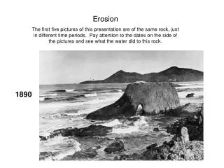
erosion
erosion. moving away from the source…. Weathering, soil & erosion…. Sediment regime: amount, size, characteristic sediment transport style in a river is governed by the amount and size of material delivered from both hillslopes and upstream this, in turn, depends on

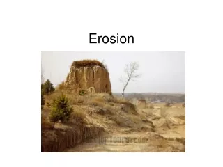
erosion
E N D
Presentation Transcript
erosion • moving away from the source…
Weathering, soil & erosion… • Sediment regime: amount, size, characteristic sediment transport style in a river is governed by the amount and size of material delivered from both hillslopes and upstream • this, in turn, depends on • erosional processes (today’s lecture) • weathering rates & style • rock properties • soil properties
Sediment Budget • along a stream reach: I - O = DS Landsliding Sediment inputs from upstream and across channel banks are balanced by either downstream sediment transport or changes in sediment storage. Soil Creep Upstream Input Stream Reach Downstream Output Bank Erosion
Erosional Processes • Soil “Creep” • Overland Flow • Landslides • Glaciers • River incision into bedrock • Bank Erosion
Erosional Processes • Soil “Creep” • Overland Flow • Landslides • Glaciers • River Incision • Bank Erosion Soil creep is the gradual, non-catastrophic downslope movement of weathered material under the influence of gravity (i.e., not by flowing water).
ways to move soil: • The burrowing activity of animals results in a net downslope transport of material that in some environments can be the dominant sediment transport process.
ways to move soil: • Tree-throw can uproot rocks and also typically results in a net downslope transport of soil and broken rock.
ways to move soil: Plowing a hillslope, ca. 1935 • human modifications… National Archives: RG083 G 36711
Soil Creep Slow, steady input of material across channel banks, or delivered to valley bottom. Typical rates of 0.1 to 1 mm yr-1. Landsliding SoilCreep Upstream Input Stream Reach Downstream Output Bank Erosion
Erosional Processes • Soil “Creep” • Overland Flow • Landslides • Glaciers • River Incision • Bank Erosion Erosion by overland flow occurs once enough flow accumulates to overcome the erosion resistance of the ground surface.
Precipitation that runs off as overland flow can cause substantial erosion once enough flow accumulates to incise the ground surface. Xc Xc is the critical distance needed to incise a channel.
Badlands environments are an extreme example where Xc may be just centimeters
Unchanneled valleys occur where the erosion resistance of the ground surface is high relative to the amount of overland flow Xc is very large.
Entrenched channels and gullies can develop in landscapes where overgrazing decreases the erosion resistance of the valley floor • Xc was large, became smaller…
Overland Flow • Erosion by overland flow is rare in forested mountain landscapes because: • rainfall tends to infiltrate into the ground • the ground has substantial erosion resistance due to vegetation • Erosion by overland flow is most common in disturbed or semi-arid landscapes
Erosional Processes • Soil “Creep” • Overland Flow • Landslides • Glaciers • River Incision • Bank Erosion Landslides involve the downslope movement of soil and/or rock under the influence of gravity and may be either slow and gradual or rapid and catastrophic.
Bedrock landslides • earth flows: some internal deformation • typically slow • relatively little water • earth flow in NZ
Soil landslides • debris flows: lots of internal deformation • rapid • relatively high water content • fluid-like flow • Failure typically occurs along well-defined shear plane at soil-bedrock interface. • debris flows along Tolt R.
landslides Scarp • Bedrock landslides can limit the relief of mountain ranges • Mt. Cook, New Zealand: • top 10 meters of summit fell away in a massive landslide/avalanche on December 14, 1991. Runout zone Deposit
Landsliding Rapid, infrequent inputs of large volumes of sediment. Rates of delivery set by landslide frequency, which is often centuries to millennia at a point. Landsliding Soil Creep Upstream Input Stream Reach Downstream Output Bank Erosion
Erosional Processes • Soil “Creep” • Overland Flow • Landslides • Glaciers • River Incision • Bank Erosion Glaciers can both entrain loose surface materials and gouge deeply into bedrock.
Glacial Erosion Rapid erosion of material from above perennial snow line. Rates can exceed 10 mm yr-1. Processes of erosion and rates depend on temperature, glacier size, precipitation rate, etc...
Erosional Processes • Soil “Creep” • Overland Flow • Landslides • Glaciers • River Incision • Bank Erosion Rivers can carve deeply into bedrock and such incision provides another source of sediment. In the world there is nothing more submissive and weak than water. Yet for attacking that which is hard and strong nothing can surpass it. - Lao-Tzu, 6th century B.C.
River Incision Erosion = f (discharge, channel width, slope) More water in a narrower channel down a steeper slope means faster river incision Rates of bedrock river incision typically range from <0.01 mm yr-1 to 1 mm yr-1, but can exceed 5 mm yr-1 in extreme topography.
Erosional Processes • Soil “Creep” • Overland Flow • Landslides • Glaciers • River Incision • Bank Erosion Bank erosion recycles material stored on the valley bottom, typically in the floodplain.
bank erosion • reworking valley-bottom sediments • entraining sediments delivered by other erosional processes • Rangitata R., NZ
Factors controlling erosion • climate • topography/slope • vegetation • lithology/erodibility • land-use
climate • precip & veg. • sediment yield: total amount of sediment generated by a particular landscape
slope Olympic Mountains
erodibility • bedrock erodibility ranges over at least 5 orders of magnitude
mountains: the big picture • weathering, soil formation & erosion interact • ultimately provide sediment for rivers & beaches…
a final thought: • rivers and beaches are important sediment transfer (material transfer)systems within larger Earth system • remember this context!