Debris Flows in Antietam Quartzite, Battle Run, Glasgow, Virginia
Study of debris flows in Antietam Quartzite Battle Run in Glasgow, Virginia. Photos and cross-sections show impact of heavy rainfall on sandstone bedrock, jointing patterns, and vegetation regrowth. Evidence of past debris flows and soil deformation are documented.

Debris Flows in Antietam Quartzite, Battle Run, Glasgow, Virginia
E N D
Presentation Transcript
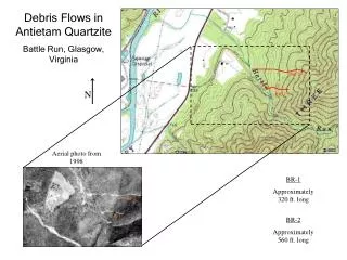
Debris Flows in Antietam Quartzite Battle Run, Glasgow, Virginia BR-2 N BR-1 Aerial photo from 1998 BR-1 Approximately 320 ft. long BR-2 BR-1 BR-2 Approximately 560 ft. long
Debris Flow in Antietam Quartzite Battle Run, Glasgow, Virginia N Flow BR-1 Path in channel of debris flow. X X1 Top bank of stream. A- Boulder of Antietam quartzite deposited by flood of stream. B- Boulder and colluvium of Antietam quartzite deposited during debris flow of 1995. A Location and approximate size of main scarp (behind trees). X 12 ft. X1 B 9 ft. Exposed bedrock Photo by Bob Sas, 2/04 Fig. 1 Cross section of flow path demonstrating exposed bedrock. In the bottom of the channel is a collection of white colored-sand, cobbles, and silty clay layer from the weathered sandstone bedrock. Plate 1 This debris flow was initiated by heavy rainfall saturating the bedrock between joints. The rocks are heavily weathered sandstones of the Chilhowee group.
Debris Flow in Antietam Quartzite Battle Run, Glasgow, Virginia X1 X 11 ft. 10 ft. Soil and cobbles Exposed bedrock N Flow BR-2 Main scarp trace. Location of old rock fall. X X1 Fig. 2 The exposed bedrock shows evidence of jointing along strike. The apparent dip of the bedding into the scarp channel is 68O. The length of this scarp is 57 ft. from tail to where the channel drops into the main flow. Photo by Bob Sas, 2/04 Plate 2 From the main scarp to the bottom of the photograph is approximately 250 ft. There are multiple exposures of bedrock under the main scarp and top slump areas. The new vegetation growing in the flow path is primarily Virginia Pine, others include grasses and thorny brush.
A B N BR-2 BR-1 Relative Locations of Photographs A N Plate 3These photographs show evidence of debris flows from an event previous to 1995. The grain supported cobbles and boulders are indicative of debris flows. The poorly sorted sizes of the deposits are another good indication that these are flow deposits and not ones emplaced through fluvial processes. The colored lines in the photos show the bottom of the flow deposit profiles. B N Photos by Bob Sas, 2/04
A1 A B D C E G F Marks the boundary of the top and bottom of the North bank of Battle Run. -------------- The location of this photograph is several feet downstream from BR-1. -------------- Photo by Bob Sas,2/04 N Plate 4 On the North bank of Battle Run is this example of an overturned soil profile. At some unknown time this profile experienced local deformation either from epeirogenesis or toppling of the beds due to shear stress. Each blue line marks the start of a new horizon. Horizons A1, D, E, and F are all heavily saprolitized. A saprolite is a “rotten rock” that contains structures of the original rock, but that has undergone significant chemical weathering to form an unconsolidated mass (Ritter, et al, 2002). The grayish-blue colors can be attributed to silica clay rich saprolites, which are on the verge of total decomposition. The Jacob’s Staff is 4.9 ft. tall.
High velocity path of debris flow. Boulder longest length is 5 ft. BR-2 BR-1 N N Location of photograph on Battle Run. Photo by Bob Sas, 2/04 Plate 5 These bouldary fronts are the result of a high velocity debris flow with enough viscosity to “float” these boulders and carry enough sediment to support them upon deposition. Boulders and downed trees form evulsions in the stream channel by choking off the water flow, thus diverting the channel around the debris.
Bibliography and Works Cited Ritter, D.F, R.C. Kochel, J.R. Miller. Process Geomorphology. 4th ed. Boston: McGraw-Hill, 2002. U.S. Geological Survey. Glasgow, VA 7.5 Minute Quadrangle (with Aerial Photography). <http://www.terraserverusa.com/> 29 Feb. 2004