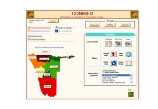
ConInfo - Conservation Data Collection in Namibia
ConInfo is a comprehensive database on conservation areas in Namibia, containing GIS map layers, documents, reports, and databases including game counts, species data, and more. Originally developed for managing GIS data, it now provides easy access to a wealth of information for various users.

ConInfo - Conservation Data Collection in Namibia
E N D
Presentation Transcript
What is ConInfo? • A collection of data and information on conservation areas in Namibia: - State Protected Areas - Conservancies - Concessions - Community Forests - Private Reserves What types of data does it contain? • Map (GIS) layers - boundaries, infrastructure, images, environmentalDocuments - fact sheets, management plans, reports, manuals etc.Information systems (databases) - game counts & quota settings - natural resource monitoring (Incident Book = parks, Event Book = conservancies) - species data (birds, mammals, trees, high value species)
History: • Developed initially as a means of managing GIS data and sharing GIS projects • a) Reduce redundancy and duplication b) Retain data integrity • Began with conservancies and concessions and grew to incorporate parks, community forests and private reserves • Data set expanded to include documents, reports, databases • Initially just a standardised folder and file system but the growing user base required the addition of a customised interface to facilitate easy access to the information
What kinds of layers are available? • Infrastructure • Conservation area boundaries • Environmental & climate data (vegetation, rainfall, altitude etc.) • Grids • Population data • Landsat images & orthophotos • Digital Elevation Model
Fact sheet Management plan
Who has access to and uses ConInfo? • A range of NGOs, consultants, students etc. scattered throughout the country • MET staff – resident and functioning on the new network server providing access for staff in Windhoek, Rundu and Keetmanshoop • NNF – network • WWF - network