Download
1 / 49
490 likes | 649 Vues
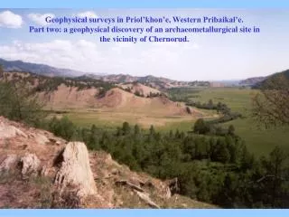
Geophysical surveys in Priol’khon’e, Western Pribaikal’e. Part two: a geophysical discovery of an archaeometallurgical site in the vicinity of Chernorud. Lake Baikal and location of Chernorud. Map of Barun-Khal valley and Chernorud. Barun-Khal valley, the university camp and Chernorud.

E N D
Geophysical surveys in Priol’khon’e, Western Pribaikal’e.Part two: a geophysical discovery of an archaeometallurgical site in the vicinity of Chernorud.
Apparent resistivity curve of the Shlumberger geoelectric sounding measured within the camp area (a), and corresponding 1D interpreted geoelectric section (b). TEM response of 20m by 20m сoincident loops centred within the camp area: (a) measured, and (b) transformed to the apparent resistivity curve.
TEM response of the small coil system in presence of a magnetic extract from the near-surface material sampled within the camp area
Element composition of slags from the atomic-emission material analysis (in wt%)
Chemical composition of the Chernorud site’s slags (in wt %)
Principal mineralogy of slags (in wt%) from the X-ray analysis results + detected, but the content couldn’t be estimated - not detected
As may be inferred from their chemical composition and mineralogy, the Barun-Khal’s slags are closely similar to those that are known to have formed during the bloomery iron reduction process. This conclusion has motivated: (i) archaeogeophysical and archaeological surveys in the Barun-Khal valley that in turn have resulted in the discovery of an Iron Age metallurgical complex dated as early as 1750-2180 years BP; (ii) extension of slag-related studies primarily by application of magnetic methods normally used in rock magnetism.
Total magnetic intensity map for the mouth part of the Barun-Khal valley (1998); survey area is 150m х 200m, surveying grid is 2m x 4m, the height of the sensor is about 2m.
3D plot of the total magnetic field intensity: the mouth of the Barun-Khal valley.
Magnetic field intensity map for the mouth part of the Barun-Khal valley: blue contoured rectangle shows the area of the 1999 surveys, and that contoured by a red line shows the area of the 2000 surveys.
Detailed magnetic surveys results) fom the mouth part of the Barun-Khal valley (2000. Surveying grid: 1m x 1m; the height of the sensor: 80 cm; contour lines interval: 5 nT. The rectangle indicates the archaeological excavation area, where no magnetic measurements were possible.
Magnetic hysteresis curves of the met-1, met-2, met-4, and met-6 samples
Magnetic hysteresis curve of the met-8 sample. Its wasp-waisted shape indicates the contribution from both stable SD and SP grains
Magnetic hysteresis data of slag samples from the Chernorud site
Thermomagnetic curves of the met-1, met-2, met-4, and met-6 samples
Estimating percent content of ferro- and ferrimagnetic minerals in slag
Mineralogical composition of slags (in wt %) from the magnetic analysis results ? there is some evidence for the presence of mineral - mineral is not detected
Anomalously slowly decaying transients are measured when carrying out TEM geophysical surveys in the vicinity of Chernorud.
Relaxation of magnetization of ultrafine (SP) particles abounding in the site's near-surface is supposed to be a likely cause.
Slag-like fragments are supposed to be candidates for the material containing SP particles where from they also were entering the soil.
Investigating chemical and mineralogical composition of the slag-like fragments indicates they are nothing but slags formed during in-bloomery iron reduction process.
Archaeogeophysical and archaeological surveys result in discovery of an Iron Age metallurgical complex in the Barun-Khal valley. According to the radiocarbon dating method, the iron smelting started here as early as 2180 years BP.
Studying magnetic properties of slags is shown to be a valuable tool for investigating their magnetic mineralogy and evaluating magnetic grain size, which, in turn, provide new ways for slags’ classification and elucidating their smelting-related features.
As in the case of naturally occurring rocks, magnetic features of slags’ ferro- and ferrimagnetic minerals are as typomorphous as their form, color, hardness, luster and other mineralogically-related properties.