Download
1 / 1
10 likes | 220 Vues
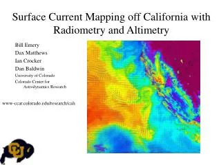
18. 10. 62. 48. 33. 18. BAIKAL ICE. Baikal Web World http://www.bww.irk.ru. METHOD. ICE / SNOW. OPEN WATER. RESULTS. SNOW COVER. ICE / SNOW. OPEN WATER. 17 cm. 33 cm. 48 cm. 62 cm. 80 cm. ICE AND SNOW COVER ON LAKES FROM RADAR ALTIMETRY AND RADIOMETRY: CASE OF LAKE BAIKAL.

E N D
18 10 62 48 33 18 BAIKAL ICE Baikal Web World http://www.bww.irk.ru METHOD ICE / SNOW OPEN WATER RESULTS SNOW COVER ICE / SNOW OPEN WATER 17 cm 33 cm 48 cm 62 cm 80 cm ICE AND SNOW COVER ON LAKES FROM RADAR ALTIMETRY AND RADIOMETRY: CASE OF LAKE BAIKAL Alexei V. KOURAEV 1,2, Sergei V. SEMOVSKI 3, Michail N. SHIMARAEV3, Nelly M. MOGNARD1, Benoit LEGRESY1, Frederique REMY1 1) Laboratoire d’Etudes en Géophysique et Océanographie Spatiales (LEGOS), Toulouse, France2) State Oceanography Institute, St. Petersburg branch, St. Petersburg, Russia 3) Limnological Institute, Siberian Branch of Russian Academy of Sciences, Irkutsk, RussiaCONTACT: kouraev@legos.cnes.fr LONG TIME SERIES OF HISTORICAL DATA Life and reproduction of Baikal seals are strongly dependent on ice conditions and snow depth BAIKAL: 20% OF WORLD FRESHWATER RESOURCES, UNIQUE WATER TRANSPARENCY, RICHNESS OF FAUNA AND FLORA Photo from Baikal Web World http://www.bww.irk.ru Long series are available online at the Global Lake and River Ice Phenology Database (NSIDC, Benson and Magnuson, 2000) for Listvyanka (1868-1996) and Nizhneangarsk (1937-1989) NEED FOR A BROADER VIEW Natural conditions differ significantly along the lake. Number of aerial surveys and expeditions has decreased dramatically since the 1990s Ice cover: good indicator of large-scale climate change, affects formation of hydrophysical fields, influences spring bloom of diatoms and primary production Ice for transport: Opening of ice route to the Ol’khon island, 11 February, 2004 General map of the lake Baikal region A - Selenga sill, B - Akademicheskiy ridge Use of satellite observations has been limited so far to the visible range (Semovski et al., Journal of Marine Systems 2000; Nordic Hydrology 2003). Data: TOPEX/Poseidon (T/P), Jason-1, ENVISAT and GFO satellites and SSM/I sensor Satellite ground track coverage of lake Baikal. a) T/P and Jason-1 (bold lines) and T/P new orbit (thin lines); b) ENVISAT; c) GFO; d) all (a+b+c) altimetric ground tracks, e) selected EASE-grid pixels of SSMI observations (rectangles) and three sub-regions of Baikal: 1 - Southern, 2 - Middle, 3 - Northern Baikal DISCRIMINATING ICE AND OPEN WATER USING COMBINATION OF SIMULTANEOUS ACTIVE (ALTIMETER) AND PASSIVE (RADIOMETER) MICROWAVE DATA All radar altimetry missions have two instruments: a dual-frequency radar altimeter, and a passive microwave radiometer. Although the primary mission of altimeters is to measure sea level, we found that the combination of active and passive microwave measurements could be used successfully for the ice cover studies A method using a combination of simultaneous active (backscatter coefficient) and passive (brightness temperatures at two frequences) microwave measurements was applied to discriminate between ice and open water(Kouraev et al, 2003 Polar Research, 2004 Journal of Marine Systems, 2004 IEEE TGRS). This information was complemented by passive microwave data set from the SSM/I instrument onboard the DMSP series (since 1987). Ice discrimination has been done using palorasation (PR) and spectral (GR) gradient ratios. COMBINING BENEFITS OFTHE TWO PLATFORMS SSM/I - wide spatial coverage, high temporal resolution Altimetry - high radiometric and along-track spatial resolution 2D histograms (number of cases) for 1992-2002. Left panel: altimetry missions in the space of backscatter coefficient versus the average value of temperature brightness at two frequencies. Right panel: SSM/I data in the space of PR*100 versus GR*1000. Two main clusters (open water and ice/ice+snow) are shown, as well as an approximate boundary between them (dashed line). APPROACH: ANALYSE COMBINED MAPS OF SURFACE TYPE DISTRIBUTION FROM ALTIMETRY AND SSM/I Working at 5 days (pentad) resolution; Altimetry and SSM/I classification should confirm each other FREEZE-UP(100% ICE) IN CONTRAST WITH LONG-TERM HISTORICAL DATA, THERE IS A RECENT COOLING TENDENCY Ice phenology (freeze-up and ice break-up dates and winter duration) for various regions of Baikal from historical (thick grey line - NSIDC data, thick black line - LIN RAS data) and satellite-derived data (average values). (Kouraev et al., RSE 2006, submitted, L&O 2006, submitted) Long-term time series for Listvyanka indicate global decrease of winter duration (with relatively stable break-up dates and later ice freeze-up dates). Our satellite-derived dates show recent (last 8-10 years) tendency for earlier freeze-up, later break-up and, consequently, increase of winter duration GOOD RELATION WITH HISTORICAL DATA FOR SOUTHERN BAIKAL FAST-ICE DURATION Line with grey dots - Southern Baikal, dashed line with black triangles - Middle Baikal, thick line with black diamonds - Northern Baikal LONG-TERM FAST ICE DURATION FROM HISTORICAL AND SATELLITE DATA Black line with grey dots - Listvyanka, black line with hollow dots - whole Southern Baikal EXTENTION OF EXISTING TIME SERIES BREAK-UP (FIRST OPEN WATER) NEW SERIES FOR REGIONS PREVIOUSLY NOT COVERED BY OBSERVATIONS (MIDDLE AND NORTHERN BAIKAL) CONSTRAINT: INFLUENCE OF AIR TEMPERATURE AND SNOW CRYSTAL SIZE ESTIMATING SNOW DEPTH FROM PASSIVE MW DATA Too high snow depth values are associated with melting/refreezing events Snow depth could be estimated using differences between brightness temperatures at 18 and 37 GHz Simplified algorithm (for 100% ice cover) hs=-2.34-771*GR To account for this, we will apply Advanced Dynamic Algorithm (Mognard and Josberger, 2002) Absolute values should be adjusted using in situ snow depth data Snow algorithm for Antarctic (Marcus and Cavaliery,1998) Snow depth (using Marcus and Cavalieri coefficients) overlayed over PR/GR distribution for SSM/I Average and maximal GR (and equivalent snow depth in red using Antarctic coefficients) from SSM/I estimates. Temporal evolution of air temperature and GR in 1996