Rationale
Spatial dependence and correlation of rainfall in the Emilia-Romagna region and its role in flood risk assessment. Mario L.V. Martina (1), Renato Vitolo (2), Ezio Todini (1), David B. Stephenson (2), Ian M. Cook (3) . Corresponding authors: mario.martina@unibo.it, r.vitolo@exeter.ac.uk.

Rationale
E N D
Presentation Transcript
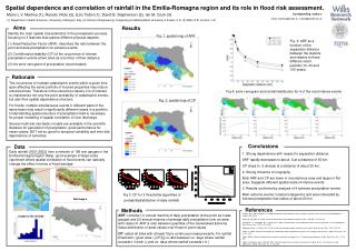
Spatial dependence and correlation of rainfall in the Emilia-Romagna region and its role in flood risk assessment. Mario L.V. Martina (1), Renato Vitolo (2), Ezio Todini (1), David B. Stephenson (2), Ian M. Cook (3) Corresponding authors: mario.martina@unibo.it, r.vitolo@exeter.ac.uk (1) Department of Earth Sciences, University of Bologna, Italy, (2) School of Engineering, Computing and Mathematics University of Exeter, U.K. (3) Willis LTD, London, U.K. Aims Results Identify the main spatial characteristics of the precipitation process, focusing on 3 features that capture different physical aspects: (1) Areal Reduction Factor (ARF): describes the ratio between the point and area precipitation for extreme events (2) Conditional probability (CP )of the occurrence of intense precipitation events at two sites as a function of their distance (3) the semi-variogram of precipitation (event-based) Fig. 1: spatial map of ARF Fig. 3: ARF as a function of the separation distance between the stations and relative to three different return periods (10, 20 and 100 years). Rationale The occurrence of multiple catastrophic events within a given time span affecting the same portfolio of insured properties may induce enhanced loss. Therefore in the insurance industry it is of interest to characterize not only the point probability of catastrophic events, but also their spatial dependence structure. For floods, multiple simultaneous events in different parts of the same basin may result in significantly different losses in a portfolio. Understanding spatial structure of precipitation field is necessary for proper modelling of spatial correlation of river discharge. Several multi-site stochastic models are available in the scientific literature for generation of precipitation: good performance for mean values, BUT not so good for temporal variability and inter-site dependence of extremes. Fig 4: semi-variogram and rainfall distribution for 4 of the most intense events Fig. 2: spatial map of CP Conclusions Data Daily rainfall (1931-2003) from a network of 168 rain gauges in the Emilia-Romagna region (Italy): good example of large-scale catchment where spatial correlation of flood events can radically change the effect in terms of flood damage. 1. Strong dependence with respect to separation distance: ARF rapidly decreases to about .5 at a distance of 50 km. CP drops to .5 already at a distance of about 20 km. 2. Strong influence of orography Both ARF and CP are lower in mountainous area and larger in flat area. Suggests different spatial scale of intense events. 3. Results confirmed by analysis of 4 extreme precipitation events Main extreme events: located in Appenine and area interested by intense precipitation has radius of about 20 km. Fig 3: CP for 3 thresholds (quantiles of probabilitydistribution of daily rainfall) Rainfauges References Methods Asquith, W.H. and Famiglietti, J.S. (2000) Precipitation areal-reduction factor estimation using an annual-maxima centered approach, J. Hydrol., 230, 55-69. Bacchi B. and Ranzi R. (1996) On the derivation of the areal reduction factor of storms, Atm.Res., 42, 123-135. De Michele , C., Kottegoda, N.T., and Rosso, R. (2001) The derivation of areal reduction factor of storm rainfall from its scaling properties, Wat. Resour. Res., 37(12), 3247-3252. Rodriguez-Iturbe, I. & Mejia, J.M. (1974) On the transformation of point rainfall to areal rainfall, Water Resour. Res., 10(4), 729-735. Todini, E., 2001a: A Bayesian technique for conditioning radar precipitation estimates to rain-gauge measurements. Hydrol. Earth Syst. Sci., 5, 187–199. Todini, 2001b: Influence of parameter estimation uncertainty in Kriging: Part 1—Theoretical development. Hydrol. Earth Syst. Sci., 5, 215–223. Todini, F. Pellegrini, and C. Mazzetti, 2001: Influence of parameter estimation uncertainty in Kriging: Part 2—Test and case study applications. Hydrol. Earth Syst. Sci., 5, 225–232. ARF: consider (1) annual maxima of daily precipitation at the point as it was gauged and (2) annual maxima of average daily precipitation over an area with radius R. ARF is ratio between quantiles of the Generalised Extreme Value distribution of areal values over those of point values CP: select all sites with at least 10yrs continuous measurements. Fix rainfall threshold t: given sites i,j CP(i|j) is ratio between no. days where rainfall exceeds t in both i,j and no. days where rainfall exceeds t in j Lenght of the records