Download
1 / 18
180 likes | 298 Vues
Potential Water Resource Monitoring Indices. Kwabena Asante & Gabriel Senay USGS EROS / FEWS NET Sioux Falls, SD 57198. U.S. Department of the Interior U.S. Geological Survey. GeoSFM Challenges.

E N D
Potential Water Resource Monitoring Indices Kwabena Asante & Gabriel Senay USGS EROS / FEWS NET Sioux Falls, SD 57198 U.S. Department of the Interior U.S. Geological Survey
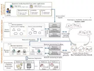
GeoSFM Challenges • Conversion between raster GIS grids and text files makes data management more difficult, particularly as number of basins get larger • Display of interactive hydrographs requires a live IMS connection which has been difficult to maintain • Getting absolute flow values correct without local calibration has been difficult
Flow Routing using River Network • Catchment delineated around the river network • Flow routed within catchments to catchment outlet • Flow goes along river network to from outlet to outlet
Impacts on Routing • Flow must be routed through even tiny river reaches • A new record is generated for each river reach each time step • Results in a large time series matrix which is difficult to manipulate
Flow Time to Basin Outlet • Time for water to travel from a given location to the basin outlet • Computed from elevation derived flow length and velocity
Bands of Daily Travel Time • Travel time to the basin outlet discretized into daily intervals • Flow time between two areas along same river can also be estimated
Identify River Exit Points for Time Zones • Identify points at which river exits daily travel time zones • Delineate catchments associated with these exit point
Travel Time Based Catchments • Water takes exactly one day to travel between the travel time-based catchments • Hence we can directly propagate daily runoff generated in a catchment to the next downstream catchment Sample Daily Runoff Grid Travel Time Based Catchments
Daily Runoff Grids • An existing operational product
Event Monitoring with Daily Runoff • Doesn’t track what happens to the excess runoff
Annual Maximum Flows 1998 2000 2002
Sample Daily Flood Hazard Indices Flood Hazard Index as a % of median annual flow Flow in absolute terms
Sample Output: Daily Flows or Storage A climatology is being computed. It will enable anomalies to be presented relative to median of peak flows (1998 – 2005).
Conclusions • A new daily flood hazard index (FHI) product is being created to simulate the movement of flow from daily runoff grids. • Flood Hazard Index (FHI) is will be presented as a percentage of median annual flood peak, and will be useful for identifying the location and relative magnitude of flood hazards. • Low daily flows do not necessarily indicate hydrologic drought as subsurface runoff yield is not being simulated. • The product could be operational within the next couple of weeks if it meets with your approval.