Download
1 / 1
20 likes | 177 Vues
John A. Lory, Dept. of Agronomy, Commercial Agriculture Program Ray Massey, Dept. of Agricultural Economics, Commercial Agriculture Program Chris Barnett, Center for Agricultural, Resource and Environmental Systems Ryan Milhollin, Commercial Agriculture Program University of Missouri.

E N D
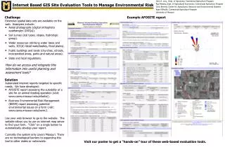
John A. Lory, Dept. of Agronomy, Commercial Agriculture Program Ray Massey, Dept. of Agricultural Economics, Commercial Agriculture Program Chris Barnett, Center for Agricultural, Resource and Environmental Systems Ryan Milhollin, Commercial Agriculture Program University of Missouri Internet Based GIS Site Evaluation Tools to Manage Environmental Risk Challenge Example AFOSITE report • Extensive spatial data sets are available on the web. Examples include: • Aerial photographs (digital orthophoto quadrangles (DOQs)). • Soil survey (soil types, slopes, hydrologic group). • Water resources (drinking water lakes and wells, 303(d) listed waterbodies, flood plains). • Public buildings and lands (churches, schools, incorporated areas, parks and natural areas). • State and local regulations. • How do we access and integrate this information into useful planning and assessment tools? Solution • Automated internet reports targeted to specific needs. We have developed: • AFOSITE report assessing the suitability of a site for an animal feeding operation (visit: www.cares.missouri.edu/afosite/). • Business Environmental Risk Management (BERM) report assessing potential environmental issues on a farm (visit: www.cares.missouri.edu/berm/). • Use your web browser to go to the website. The website allows you to use an internet map server to find your farm. “Click” on a single button to automatically develop your report. • Currently the system only covers Missouri. There are no technological barriers to expanding this tool to other states or nationwide. Visit our poster to get a “hands-on” tour of these web-based evaluation tools.