Download
1 / 32
320 likes | 409 Vues
Discover the significance of uncertainty indicators in hydrographic data for informed decision making and enhanced navigation safety. Learn about ISO 19113 data quality subelements and uncertainty management steps.

E N D
The Increasing Need to Provide Uncertainty Indicators to Users of Hydrographic Products Beyond Safety of Navigation Multibeam & Visualization Workshop Gulfport 26-29 July 2004 UNB GGE5072 & GGE 6021 students USM HYD605 students Rob Hare, Dave Monahan, Dave Wells Uncertainty Indicators
“Fit for intended use” (again) • The purpose of hydrographic information whether for safety of navigation, or for applications “beyond safety of navigation”, is to • support informed decision making • The quality of the information will affect the quality of the decisions made based upon it. • End users must be informed about the quality of the data upon which they base their decisions. Uncertainty Indicators
ISO 19113 Data quality subelements • completeness • commission: excess data / omission: data absent • logical consistency • conceptual consistency / domain consistency / format consistency / topological consistency • positional accuracy • absolute or external accuracy / relative or internal accuracy / gridded data position accuracy • temporal accuracy • accuracy of a time measurement / temporal consistency / temporal validity • thematic accuracy • classification correctness / non-quantitative attribute correctness / quantitative attribute accuracy Uncertainty Indicators
Outline • Exerpts from • CHC2004 Workshop / Tutorial • Uncertainty Management in Hydrography • 24 May 2004 • Organized by Sue Sebastian • Quality Assurance Branch Head • Naval Oceanographic Office • Full proceedings available at • ftp://moray.dms.usm.edu/CHC2004_Uncertainty_Workshop Uncertainty Indicators
The way it was • In past decades, positioning methods used for hydrographic surveys were always more accurate than chart users could navigate. • Navigators were trained to allow a margin of error for the inaccuracy of their own positioning. • Inaccuracies in the charts did not need to be taken into account. Hans van Opstal, Melaha 2004 Uncertainty Indicators
The way it is now • Almost all navigators use the Global Positioning System (GPS), or even differentially-corrected GPS (DGPS). • These provide far better accuracy than was available when the surveys for most existing charts were performed. • Many users of nautical charts have no idea how uncertain is the information shown on the charts they are using. • This lack of appropriate information leads to inappropriate navigation decisions, groundings, and perhaps loss of life. • Statistics: Over half of the inshore US NOAA nautical charts were acquired by lead-line and sextant surveying prior to 1940. Over 25% of the charted areas on the Canadian British Columbia coast are based on lead-line and sextant surveys. Hans van Opstal, Melaha 2004 Uncertainty Indicators
The way it will be • High-density survey methods (multibeam sonar, LIDAR, acoustic sweeps) can now provide complete seafloor coverage in digital form. • This allows a much more sophisticated approach to uncertainty management. • New ideas have emerged that may fundamentally change the way hydrographic data is managed (e.g. CUBE). • BUT • Most charts, for many many years, will remain based on legacy data, for which these new approaches have limited application. Uncertainty Indicators
Uncertainty management steps • Specification: What decisions (navigation and non-navigation) will be based on hydrographic data? What 95% confidence level uncertainty do these decisions require? • Design: Select equipment, survey procedures and data processing methods which will likely meet the specification. • Attribution: Measure and/or model parameters that describe the uncertainty of the collected data. • Assurance: Include redundancy and calibration procedures to permit assessing actual uncertainties and 95% confidence regions, against predicted uncertainties. • Presentation: Provide uncertainty results in an easily understood way to those making decisions based on multibeam survey results. A big difference here between legacy and high-density data. Uncertainty Indicators
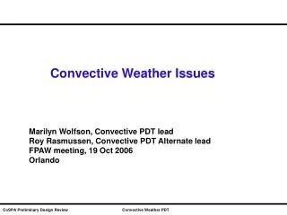
TPE (attribution) • Total Propagated Error: an attempt to account for all influences on depth and position uncertainty • Input: all sensor (and processing) uncertainties • Using: Law of propagation of variances • Output: predicted uncertainties in depth and position. • Example: depth uncertainty depends on • Measurement uncertainties: echosounder range and beam angle, heave, pitch, roll, water level and sound speed profile. • Configuration uncertainties: sensor geometric and time offsets, and misalignments. • Model uncertainties: draft, squat, load, induced heave, temporal and spatial variability in water level and sound speed, echosounder beam steering. • These uncertainties vary with beam angle, depth, sea state, bottom type etc. Uncertainty Indicators
Example: Depth error estimates From Rob Hare Uncertainty Indicators
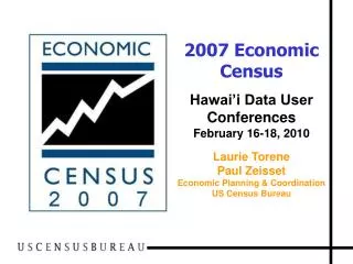
Example: position error estimates From Rob Hare Uncertainty Indicators
The Hare-Calder-Smith method to manage uncertainty • 1 (Hare - TPE) Compute 3D uncertainty attributes for every depth data point, using theoretical or empirical models for sensor errors. • 2 (Calder - CUBE) Propagate depths & uncertainties to nodes. Allow alternative hypotheses. Use several “disambiguation” metrics. • 3 (Smith - Nav Surface) Maintain rare “golden” shoal depths. Defocus shoals to represent georef uncertainty. Generalize by 3D double-buffering. Uncertainty Indicators
Representing uncertainty on legacy (paper) charts • Option 1 - No information provided / available • Option 2 - Source Diagram (SD) describes parameters of the field survey (e.g. date, line spacing, agency, depth sensor, georeferencing sensor, etc.) • Option 3 - Reliability Diagram (RD) advises on preferred areas for navigation, and provides uncertainty assessment (e.g. sounding accuracy, line spacing, survey classification - controlled, lead-line, sounder, shoals examined, sonar swept, etc.) • Option 4 - Represent hazards (rocks, soundings, contours) directly on chart by use of colour and / or pecked lines around hazards Uncertainty Indicators
3 Methods of Representing Uncertainty • Two methods, a Source Diagram (SD), and a Reliability Diagram (RD) are graphical insets on a paper chart • Showing the geographical limits for each survey • A table describing the attributes of each survey area in the diagram • Zone of Confidence (ZOC) methods used on Electronic Navigational Charts (ENC) • No standard method exists for Raster Navigational Charts (RNC) - the most widely used form of chart display (being used by the Gordon Reid). Uncertainty Indicators
Source Diagram (SD) information • Organization performing survey • Date of survey • Scale of survey • Line spacing information Uncertainty Indicators
Model Source Diagram IHB M4 Uncertainty Indicators
Reliability Diagrams • Give an assessment of accuracy as well as advising on preferred areas for navigation • Examples of the attributes • Estimated accuracy of soundings • Distance between survey sounding lines • Classification of the survey (e.g. reconnaissance or incomplete; controlled; sounded by lead line; sounded by echosounder; shoals have been examined; has been sonar swept) Uncertainty Indicators
Model Reliability Diagram IHB M4 Uncertainty Indicators
Zones of Confidence (ZOC) • ZOC values assigned to areas on an ENC • A1/A2: Full bottom ensonification with • depths determined for all • significant features • B: Uncharted hazards may exist • C: Uncharted depth anomalies are • expected • D: Large depth anomalies are expected • U: Unassessed • Specific depth and position uncertainties are assigned to each ZOC classification. Uncertainty Indicators
Survey of 21* hydrographic agencies • Asked 5 questions about representing uncertainty on charts • Very diverse responses • *Australia, Canada, Denmark, Finland, Greece, Hong Kong, Iceland, Italy, Mexico, Netherlands, New Zealand, Norway, Poland, Portugal, Saudi Aramco, South Africa, Sweden, Turkey, UK, US NGA, US NOAA Uncertainty Indicators
How is uncertainty represented on paper charts? • Some agencies do not use SDs or RDs at all (one agency removed SDs from their charts, since they were not kept updated, and are useless for RNCs). • Some agencies use SDs only on larger scale charts (larger scale being defined very differently in different countries). • Most agencies are in the process of adding SDs to their charts. • One agency claimed all their charts had SDs. Uncertainty Indicators
Are ZOC values on your ENCs fully attributed? • 40% have full ZOC attribution on all ENCs (however half of these use only ZOC values B and C, or in one case only B on all ENCs). • 30% use only U attribution so far. • 30% are partway to full attribution. • Reasons for not having full ZOC attribution were • lack of resources, • lack of metadata upon which to base the ZOC, and • the liability implied by assigning a ZOC. Uncertainty Indicators
How else do you communicate information on chart uncertainties to users? • 60% use Notices to Mariners • 25% used each of web-pages, other nautical publications, and presentations to user groups. • The Danish hydrographic office booklet “Behind the Nautical Chart” is free for downloading from its website. This booklet explains the uncertainty associated with hydrographic survey methods over the years (and is soon to be translated from Danish to English) Uncertainty Indicators
Email from Ole Berg 15 July 2004 • I promised you an informal translation of the publication. It has been undergoing revision, and is not quite complete. Nevertheless, I forward you a copy of the publication in its present form. I do apologize for the English language, especially in the preface and the introduction, it is quite horrible. This will be dealt with before the final version is published. The intention is to publish it in Danish and in English language versions, both being official publications. When complete I will forward you a new copy. • Ole Berg • Senior Adviser / Geodata - Strategy & Development • Ministry of The Environment Kort & Matrikelstyrelsen • Rentemestervej 8 / DK-2400 København NV • Tel +45 3587 5050/ direct +45 3587 5112 / mobile +45 4010 2120 / fax 3587 5059 • Email: olb@kms.dk / official email: kms@kms.dk / web: www.kms.dk Uncertainty Indicators
Are you satisfied with your current policies and practices? • 30% answered yes, • 60% answered with a qualified or unqualified no, and • 10% dodged the question (e.g. “we will always try to improve”). • The qualified no answers were based on a desire for better methods than SDs, RDs or ZOCs, and on liability issues associated with RDs and ZOCs. Uncertainty Indicators
Are you considering any changes to these policies and practices? • 40% intend to work towards completion of SDs on all paper charts, and / or full ZOC attribution on all ENCs. • 35% seek improvements to their entire hydrographic data management strategy, incorporating better ways of managing and displaying uncertainty information to the user. • 10% answered they would comply with any new international standards that might emerge. • 15% answered no. Uncertainty Indicators
What to do?1. Define what the end user wants / needs • Commercial Shipping • Fishing and Natural resources • Recreational users • Military/Coast Guard • GIS applications • Each group may have different needs and different preferences for uncertainty representation. • Establish product enhancements based on input from user groups. • Common factor must be improved situational awareness. • What enhancements will most improve the safety and decision making of the Navigator? Uncertainty Indicators
What to do?2. Address operational needs • How and under what circumstances will uncertainty representation be used? • Voyage planning. • Weather maneuvering. • Shipboard medical emergency. • Result: Time critical decision making requires clear depiction of reliability. Uncertainty Indicators
Source DiagramBest for voyage planning Uncertainty Indicators
Primary chart depictionBest for time-critical decision making. Rocks, soundings and depth contours printed in red (Gulf of Finland) Uncertainty Indicators
What to do?3. Source Diagram attributes • Survey details including: • Date of survey • Survey and positioning technology used • Line spacing/amount of coverage • Given by either exact survey details, or by a classification scheme to maximize clarity and simplicity • Timeless, without the use of descriptive quality terms such as “modern standards” or “current technology” Uncertainty Indicators